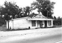
Bargain Center Supermarket on site affected by the widening of U.S. Route 17. Presumably located in southern Charleston County. Surveyor notations on back of photo: "Dkt.: 10.600. Property owner: Vernon A. Ellis. Tract: 3. Station: 512± - 514± Rt. Date: Sept. 18, 1968." [See collection description for explanation of surveyor notations.]
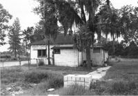
Bargain Center Supermarket (side/corner view, rear) on site affected by the widening of U.S. Route 17. Presumably located in southern Charleston County. Surveyor notations on back of photo: "Dkt.: 10.600. Property owner: Vernon A. Ellis. Tract: 3. Station: 512± - 514± Rt. Date: Sept. 18, 1968." [See collection description for explanation of surveyor notations.]
Right of way--South Carolina--Charleston County, Highway planning--South Carolina--Charleston County, Commercial buildings--South Carolina--Charleston County, Vernacular architecture--South Carolina--Charleston County, Lost architecture--South Carolina--Charleston County, Supermarkets--South Carolina--Charleston County✖[remove]2
Charleston County (S.C.)--Buildings, structures, etc.✖[remove]2