Page 66 of the City Engineer's Plat Book with fourteen plats. Plat 1 features buildings located near the intersection of King Street and Clifford Street. Plat 2 shows lots and structures located near the intersection of "Comings Street" and Wentworth Street. Plat 3 shows a lot and structures located on Pitt Street. Plat 4 shows lots located on a city block between Smith Street and Pitt Street, and between Montague Street and Wentworth Street. Plat 5 shows lots located on a city block between Montague Street and Wentworth Street, and between South Street and Rutledge Street. Plat 6 features a lot located near the intersection of "Comings Street" and Montague Street. Plat 7 shows lots and some structures located near the intersection of Bull Street and Coming Street. Plat 8 shows a lot and buildings located on Bull Street. Plat 9 Shows lots located near the intersection of Smith Street and Boundary Street. Plat 10 shows lots located on a city block between Lynch Street and Rutledge Street, and between Bull Street and Montague Street. Plat 11 shows lots and structures located near the intersection of Pitt Street and Bull Street. Plat 12 is features a lot located at the intersection of Pitt Street and Bull Street. Plat 13 Features lots located near the intersection of Bull Street and Lynch Street. Plat 14 shows lots located on Queen Street.
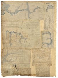
Page 88 of the City Engineer's Plat Book with eight plats. Plat 1 shows a stream and marshland starting at the Ashley River. Plat 2 features land located near the Ashley River and Grove Street. It also features several structures, some marshland, and a creek. Plat 3 shows land located near Grove Street, including some structures, some marshland, and a stream. Plat 4 shows land located Grove Street, including some buildings, a creek, and marshland. Plat 5 shows lots located between a stretch of marsh and Rutledge Avenue. Plat 5 also shows Congress Street, Legare Street, Huger Street, Moultrie Street, and a race track. Plat 6 features Washington Race Course, located between Grove Street and Moultrie Street, and between Congress Street and an unlabeled Street. Plat 7 shows "34 acres of Marsh" located between the Ashley River and a public cemetery. Plat 8 shows marshland located on the Ashley River, near "new Spring Street" and a creek.
Page 19 of the City Engineer's Plat Book with six plats. Plat 1 shows lots and buildings located near the intersection of Pitt Street and Bull Street. Plat 2 shows lots and buildings located near the intersection of Meeting Street and Reid Street. Plat 3 shows lots between King Street and Congress Street, also located near Grove Street and Moultrie Street. Plat 4 shows a lot on Amen Street labelled "Thomas N. Gadsen Esq." and noting multiple brick buildings. Plat 5 shows lots located on Cumberland Street. Plat 6 shows lots located on Amen Street and two two-story brick buildings.
Page 52 of the City Engineer's Plat Book with seven plats. Plat 1 features a lot located on Queen Street. Plat 2 shows land between New Street and the Ashley River Channel, including stretches of Tradd Street, Broad Street, New Street, Savage Street, Rutledge Street, and Lynch Street. Plat 2 also shows some marshlands in the area. Plat 3 shows lots located along Greenhill Street, near the intersection with Tradd Street. Plat 4 shows an area similar to Plat 2, with certain buildings and marshlands labelled. Plat 5 shows a lot located on the intersection of Tradd Street and New Street, featuring several buildings and other structures. Plat 6 shows land located near Tradd Street, with marshes and shoals labelled. Plat 7 features lots between Tradd Street and Gibbes street, and has a label reading "City marshland." Plat 7 also shows New Street, Savage Street, and Council Street.
Page 51 of the City Engineer's Plat Book with seven plats. Plat 1 shows land located between Tradd Street and the Ashley River, and labels several features of geography such as a patch of marsh and some land labelled "Hard at low water." Plat 1 also shows a lot labelled "City Lands." Plat 2 shows lots and buildings located near the intersection of Tradd Street and Savage Street. Plat 3 shows land located on the west side of New Street. Plat 4 features a lot located at the intersection of New Street and Tradd Street. Plat 5 features lots located near the intersection of New Street and Tradd Street. Plat 6 shows lots located on and near Tradd Street. Plat 7 shows structures located near the intersection of New Street and Broad Street, including a building labelled "Theatre."
Page 54 of the City Engineer's Plat Book with six plats. Plat 1 shows lots located near the intersection of Broad Street and Friend Street. Plat 2 shows land between the Ashley River's low water mark and Smith Street, and between Beaufain Street and Broad Street. It also labels Comings Creek, and an "Edge of High Land." Other Streets on Plat 2 include "Barre Street," Gadsden Street, Beaufain Street, Lynch Street, Queen Street, and Rutledge Street. Plat 3 shows numerous city blocks, "School Land," and a large creek near the Ashley River. Other streets on Plat 3 include Beaufain Street, Wentworth Street, Montague Street, Bull Street, and Pitt Street. Plat 4 shows a similar stretch of land to Plat 3. Plat 5 shows features a lot on Beaufain Street. Plat 6 shows a lot and buildings located near the intersection of King Street and Hutson Street.
A letter from Thomas S. Grimke to Philadelphia bookseller Thomas Kite, asking his opinion of Mr. Price, an attorney, but also giving details on military preparations and a fear of violence over the nullification issue in Charleston.
Letters of Mary Smith Grimke, wife of John Faucheraud Grimke, to her daughter, Anna Rutledge Grimke Frost (1795-1882), in Philadelphia, regarding the drowning death of her son, Benjamin (1798-1825) and his child, her grieving daughter-in-law Mary Augusta Barron Grimke (1806-1843).
A cash book for Robert F.W. Allston for the years 1823-1843. The book includes account transactions conducted by Allston including payment of overseer wages, the hiring out of enslaved people, transportation, taxes, governesses, nurses, crops, sundries, and cloth distributed to slaves. This book also includes accounts between Allston and other individuals including the Estate of Charlotte A. Allston (primarily for the purchases of blankets, shoes, and cloth for enslaved people) and an account with Mary P. Jones. The last several pages of the book contain cash ledgers. Allston explicitly notes accounting related to Matanza Plantation, later known as Chicora Wood. Other account records do not explicitly state plantation sites.
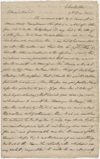
Letters of Mary Smith Grimke, wife of John Faucheraud Grimke, to her daughter, Anna Rutledge Grimke Frost (1795-1882), in Philadelphia, regarding the drowning death of her son, Benjamin (1798-1825) and his child, her grieving daughter-in-law Mary Augusta Barron Grimke (1806-1843) and the return of the bodies to Charleston, to be buried in St. Paul's cemetery. With references to settling of her husband's (?) estate, a note to her granddaughter as well and references to "Sally" (Sarah) and Angelina Grimke, especially the latter's turning to religion, attending Presbyterian services, giving up fashionable company and dress and becoming more like her sister Sarah.