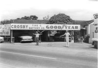
Crosby Tire & Battery Co., on site affected by the construction of Interstate 26 (I-26). [Address 2204 or 2206 Meeting Street Road.] Surveyor notations on back of photo: "Dkt.: 10.490. Property owner: M. Crosby. Tract: 66. Station: 5803+30 Lt. Line 'F'. Date: September 12, 1962. To be cut at R/W." [See collection description for explanation of surveyor notations.]
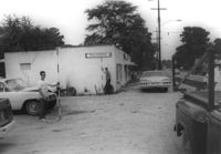
Mike's (possibly a garage), on site affected by the widening of State Road 13 (Remount Road). Trailer park in background. Surveyor notations on back of photo: "Dkt.: 10.562. Property owner: Edwards Realty Co. Tract: 5. Date: Jul. 12, 1967." [See collection description for explanation of surveyor notations.]
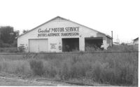
Coastal Motor Service, on site affected by the construction of Interstate 26 (I-26). Surveyor notations on back of photo: "Dkt.: 10.490. Property owner: Ashley River Realty Co. Tract: 141. Station: 5872+00 Lt. Date: August 29, 1962. Proximity." [See collection description for explanation of surveyor notations.]
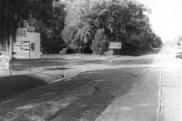
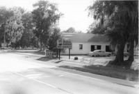
Lot and building (Basha's Garage) on site affected by the widening of U.S. Route 17. Posted signs for Basha's Garage. Presumably located in Mount Pleasant or vicinity. Surveyor notations on back of photo: "Dkt.: 10.439. Property owner: Ernest P. Basha, et al. Tract: 22-A. Station: 246+94 Lt. Date: Jul. 22, 1965. Looking from west at range poles on 33' & 50' R/W with trees in R/W." [See collection description for explanation of surveyor notations.]
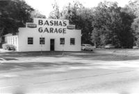
Basha's Garage on site affected by the widening of U.S. Route 17. Building facade has stepped parapet. Presumably located in Mount Pleasant or vicinity. Surveyor notations on back of photo: "Dkt.: 10.439. Property owner: Ernest P. Basha, et al. Tract: 22-A. Station: 246+94 Lt. Date: Jul. 22, 1965. Proximity." [See collection description for explanation of surveyor notations.]
Lot and building (Basha's Garage) on site affected by the widening of U.S. Route 17. Posted signs for Basha's Garage. Presumably located in Mount Pleasant or vicinity. Surveyor notations on back of photo: "Dkt.: 10.439. Property owner: Ernest P. Basha, et al. Tract: 22-A. Station: 246+94 Lt. Date: Jul. 22, 1965. Proximity." [See collection description for explanation of surveyor notations.]
Limit your search
SCDOT Photographs: Properties in the Right-of-Way✖[remove]26
Right of way--South Carolina--Charleston County, Highway planning--South Carolina--Charleston County, Commercial buildings--South Carolina--Charleston County, Vernacular architecture--South Carolina--Charleston County, Lost architecture--South Carolina--Charleston County, Automobile repair shops--South Carolina--Charleston County✖[remove]26