Willis writes from the Confederate Army of the Potomac, two miles from the Chickahominy River, on the privations of camp [though he is accompanied by a slave, Paris], and the expectation of a large scale engagement. He is spiritied by news of Stonewall Jackson's successes.
Willis writes from the centre of the Army of Richmond of the loses of the 5th and 6th South Carolina Regiments, skirmishes around camp and his concern for James Island, his family and the location of their slaves
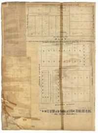
Page 159 of the City Engineer's Plat Book with five plats. Plat 1 shows lots and structures located on East Bay Street, between Hasell Street and Cumberland Street. Plat 2 features a lot located on King Street, between Hudson Street and Tobacco Street. Plat 3 shows lots located between State Street and East Bay Street, located near their intersections with Market Street. Plat 4 shows lots located along "Horlbecks Alley," between King Street and Meeting Street. Plat 5 shows lots located on Short Street, between Mazyck Street and Franklin Street.
Page 160 of the City Engineer's Plat Book with four plats. Plat 1 shows a stretch of Mazyck Street, near its intersections with Queen Street and Short Street. Plat 2 shows lots and structures located on and near Reid Street, between Drake Street and Bay Street. Plat 4 shows lots and structures located between Nassau Street and Meeting Street, and between Stewart Street and Johnson Street.
Page 163 of the City Engineer's Plat Book with two plats. Plat 1 shows lots and structures located on Friend Street, near its intersections with Queen Street, Broad Street, and an unlabeled street. Plat 2 shows lots located on King Street, near where it intersects with Broad Street.
Diary of Magdalen Elizabeth Wilkinson Keith for the years 1862-1865. Includes mostly day to day affairs and gossip, with occassional references to the War - particularly in early 1865.
1862, 1885, 1850, 1815, 1866, 1873, 1830, 1833, and 1787
Description:
Page 60 of the City Engineer's Plat Book with eight plats. Plat 1 shows lots near East Bay Street, and the intersection of Washington Street and Inspection Street. Plat 2 shows lots and a building located near Market Street. Plat 3 shows lots located between Washington Street and Marsh Street, and between Inspection Street and Calhoun Street. Plat 4 shows plots located on Market Street with a dotted line labeled "Line of Street proposed by the City." Plat 5 shows plots and structures located near East Bay Street. Plat 6 shows lots located near the intersection of Concord Street and Inspection Street. Plat 7 shows lots located near the intersection of Pinckney Street and East Bay Street. Plat 8 shows a dock and wharf on the Cooper River.
![053. Willis Keith to Anna Bella Keith -- [Sept?] 22, 1862.](https://iiif.library.cofc.edu/iiif/2/24936/full/200,/0/default.jpg)