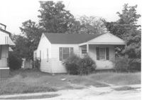
House on site affected by the construction of Interstate 26 (I-26). Address: 2124 Weaver Avenue. Surveyor notations on back of photo: "Dkt.: 10.490. Property owner: Harry L. Rumph, Jr. Tract: 188. Station: 5887±00 Lt. Date: August 29, 1962. In R/W - Bought." [See collection description for explanation of surveyor notations.]
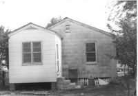
House (rear view) on site affected by the construction of Interstate 26 (I-26). Address: 2124 Weaver Avenue. Surveyor notations on back of photo: "Dkt.: 10.490. Property owner: Harry L. Rumph, Jr. Tract: 188. Station: 5887±00 Lt. Date: August 29, 1962. In R/W - Bought." [See collection description for explanation of surveyor notations.]
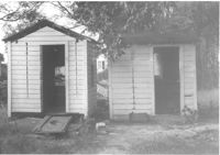
Two sheds on site affected by the construction of Interstate 26 (I-26).Address: 2124 Weaver Avenue. Surveyor notations on back of photo: "Dkt.: 10.490. Property owner: Harry L. Rumph, Jr. Tract: 188. Station: 5887±00 Lt. Date: August 29, 1962. In R/W - Bought." [See collection description for explanation of surveyor notations.]
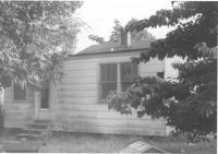
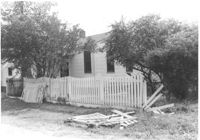
House on site affected by the construction of Interstate 26 (I-26). Address: 2122 Weaver Avenue. View of house partially obscured by trees. Surveyor notations on back of photo: "Dkt.: 10.490. Property owner: Ola C. Verdier [Olar C. Verdier?]. Tract: 189. Station: 35' Lt. Sta. 5887+45. Date: May 15, 1962. In R/W - Bought." [See collection description for explanation of surveyor notations.]
House (rear view) on site affected by the construction of Interstate 26 (I-26). Address: 2122 Weaver Avenue. Surveyor notations on back of photo: "Dkt.: 10.490. Property owner: Olar C. Verdier [Ola C. Verdier]. Tract: 189. Station: 35' Lt. Sta. 5887+45. Date: May 15, 1962. In R/W - Bought." [See collection description for explanation of surveyor notations.]
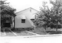
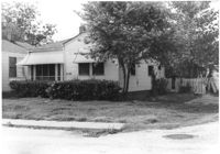
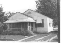
House on site affected by the construction of Interstate 26 (I-26). Address: 2120 Weaver Avenue. Surveyor notations on back of photo: "Dkt.: 10.490. Property owner: Troy R. Bevill. Tract: 190. Station: 65' Lt. Sta. 5887+55. Date: May 15, 1962. In R/W - Bought." [See collection description for explanation of surveyor notations.]
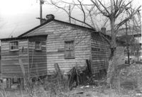
House (freedman's cottage) (rear view) on site affected by the construction of the Crosstown. Address: 6 Lee Street. Elevated roadway (presumably the off-ramp of the Grace Memorial Bridge) in background. Surveyor notations on back of photo: "Dkt.: 10.518. Property owner: William Parrineau, et al. Tract: 72. Station: 53+60 Lt. N.B. lane Route 17. 30+30Rt. Lee Street survey. Date: Mar. 7, 1963. In R/W - Bought." [See collection description for explanation of surveyor notations.]
House (rear view) on site affected by the construction of Interstate 26 (I-26). Address: 2120 Weaver Avenue. Surveyor notations on back of photo: "Dkt.: 10.490. Property owner: Troy R. Bevill. Tract: 190. Station: 65' Lt. Sta. 5887+55. Date: May 15, 1962. In R/W - Bought." [See collection description for explanation of surveyor notations.]
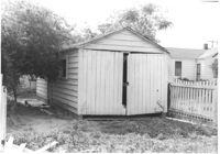
Shed on site affected by the construction of Interstate 26 (I-26). Address: 2120 Weaver Avenue. Surveyor notations on back of photo: "Dkt.: 10.490. Property owner: Troy R. Bevill. Tract: 190. Station: 100' Lt. Sta. 5887+00. Date: May 15, 1962. In R/W - Bought." [See collection description for explanation of surveyor notations.]
House on site affected by the construction of Interstate 26 (I-26). Address: 2119 Weaver Avenue. Surveyor notations on back of photo: "Dkt.: 10.490. Property owner: Marion Butler, et al. Tract: 192. Station: 5888+50 on CL. Date: May 15, 1962. In R/W - Bought." [See collection description for explanation of surveyor notations.]