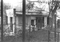
Structure on site affected by the construction of the Crosstown. Address: 122 Sheppard Street. Surveyor notations on back of photo: "Dkt.: 10.524. Property owner: Archie B. Hollins. Tract: 136. Station: 17+40 Lt. S.B. lane. Date: Dec. 2, 1964. Outside R/W." [See collection description for explanation of surveyor notations.]
Structure and lot on site affected by the construction of the Crosstown. Address: 160 Cannon Street. Surveyor notations on back of photo: "Dkt.: 10.524. Property owner: Mabel M. Cecil McIherney. Tract: 7. Station: 62+75 CL Lt. Date: Oct. 13, 1964. Portion In R/W - Bought." [See collection description for explanation of surveyor notations.]
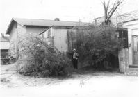
Structure (rear view) on site affected by the construction of the Crosstown. Address: 185 Spring Street. Surveyor notations on back of photo: "Dkt.: 10.524. Property owner: Star Gospel Mission. Tract: 15. Station: 24+50 Rt. (Spring Street). Date: Oct. 13, 1964. Portion in R/W to be removed." [See collection description for explanation of surveyor notations.]
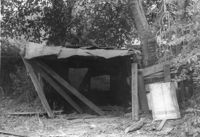
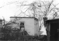
Structure (shed?) in dilapidated condition on site affected by the construction of the Crosstown. Address: 79 Kracke Street. Surveyor notations on back of photo: "Dkt.: 10.524. Property owner: Ella Lawrence, Est. Tract: 70. Station: 77+30 Lt. Date: Oct. 14, 1964. In R/W - Bought." [See collection description for explanation of surveyor notations.]
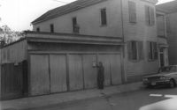
Structure (garage?) on site affected by the construction of the Crosstown. Address: 161B Line Street [161 Line Street]. Neighboring house in picture; see US Route 17 Photo 363. Surveyor notations on back of photo: "Dkt.: 10.524. Property owner: John H. Rathjen, et al. Tract: 104. Station: 83+05 Rt. Date: Dec. 1, 1964. Owner to move from R/W." [See collection description for explanation of surveyor notations.]
Structure on site affected by the construction of the Crosstown. Address: 3 Todd Street. On property of previous photos 413-415. Surveyor notations on back of photo: "Dkt.: 10.524. Property owner: John W. Bonaparte, et al. Tract: 118. Station: 87+35 Rt. Date: Dec. 1, 1964. In R/W - Bought." [See collection description for explanation of surveyor notations.]
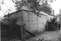
Rear view of structure on site affected by the construction of the Crosstown. Address: 81 Kracke Street. Surveyor notations on back of photo: "Dkt.: 10.524. Property owner: Jerry M. Devoe. Tract: 69. Station: 77+40 Lt. Date: Oct. 14, 1964. In R/W - Bought." [See collection description for explanation of surveyor notations.]
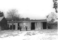
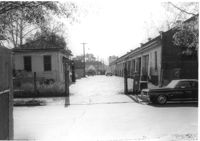
Looking down driveway between City Garage and building with gas pump, on site affected by the construction of the Crosstown. Address: 134 Line Street. Surveyor notations on back of photo: "Dkt.: 10.524. Property owner: City of Charleston. Tract: 128. Station: 91+00 CL Rt. Date: Dec. 2, 1964. Panoramic view." [See collection description for explanation of surveyor notations.]