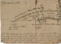
Plan of a parcel of land situated on Johns Island and containing 86 1/2 acres. Being part of a body of land belonging to Thomas Mathews. Bounded northwardly by a public road, eastwardly on James Legare's land, and southwardly on land belonging to Isaac Holmes and Thomas Legare. Intended to be conveyed to Isaac Holmes. Names associated with this plat are Thomas Mathews, Isaac Holmes, Thomas Legare, William Stanyarn, Matthews and James Legare.
Copy of a plan annexed to a deed for 177 acres given by Ebenezer Simmons to the John's Island Society lying adjoining the church on Johns Island. Names associated with this plat are Johns Island Society, Ebenezer Simmons, James Lawson, Robert Gibbes, William Boone, John Freer, George Scott, Thomas Smith, Daniel Doyley, Joshua Ward, John Hanyon, John Moultrie, Isaac Wraught, and John Stanyarn.
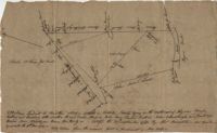
200 acres laid out to Jonathan Stocks situated in Colleton County lying on the side of Kywa [Kiawah] Creek, shows surrounding properties with no land type or detail. Names associated with this plat are Jonathan Stock, John Jones, John Edenborough, Thomas Jones, and Thomas Weatherby.
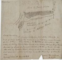
Plat of 230 acres on Johns Island. Little detail included on the plat, but there is an short explanation of the deed. Names associated with this plat are John Jones, Ebenezer Simmons, James Witter, Samuel Palmevine, John Palmavin, and Welkins. Notable geographic locations included in this plat are the Keiwaugh [Kiawah] River, Coll’s Creek, Savannah Tract, Johns Island, and Colleton County.
Lands of Paul Guerard called “The Hut," shows a public road and creeks, includes measurements. Names associated with this plat are Parker, W.B. Guerard, William Blacklock, Micah Jenkins, Thomas Humscoube, and Paul C. Grimball.
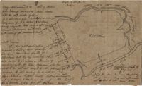
Plat of land with rice fields and highlands noted along with the neighboring properties. Very little other detail or explanation given. Names associated with this plat include Carson, Isaac Waight, and Ann Stanyarn.