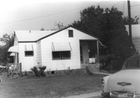
House on site affected by the construction of Interstate 26 (I-26). Surveyor notations on back of photo: "Dkt.: 10.480. Property owner: Mrs. Lila Hutto. Tract: 280. Station: 5729+00 Lt. (Line C). Date: May 31, 1961. Proximity." [See collection description for explanation of surveyor notations.]
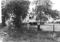
House (rear view) and yard, on site affected by the construction of Interstate 26 (I-26). Surveyor notations on back of photo: "Dkt.: 10.480. Property owner: Mrs. Lila Hutto. Tract: 280. Station: 5729+00 Lt. (Line C). Date: May 31, 1961. Proximity." [See collection description for explanation of surveyor notations.]
Right of way--South Carolina--Charleston County, Highway planning--South Carolina--Charleston County, Vernacular architecture--South Carolina--Charleston County, Lost architecture--South Carolina--Charleston County, Dwellings--South Carolina--Charleston County✖[remove]282