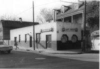
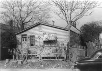
Carl's House (corner view) on site affected by the construction of the Crosstown. Address: 493 Rutledge Avenue. View of street corner. Surveyor notations on back of photo: "Dkt.: 10.524. Property owner: Elise C. Goldberg, et al. Tract: 105. Station: 84+40 Rt. Date: Dec. 1, 1964. In R/W - Bought." [See collection description for explanation of surveyor notations.]
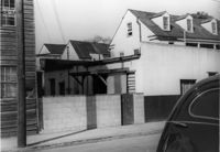
Rear portion of Carl's House, a structure (restaurant or bar) on a site affected by the construction of the Crosstown. Address: 493 Rutledge Avenue. Surveyor notations on back of photo: "Dkt.: 10.524. Property owner: Elise C. Goldberg, et al. Tract: 105. Station: 84+40 Rt. Date: Dec. 1, 1964. In R/W - Bought." [See collection description for explanation of surveyor notations.]
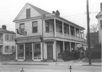
House on site affected by the construction of the Crosstown. Address: 197 Spring Street. First story is Jones Dry Cleaners and Laundry. Corner of Spring Street and Wescott Court. Surveyor notations on back of photo: "Dkt.: 10.524. Property owner: Annie Henrietta Masche. Tract: 172. Station: 22+85 Rt. Spring Street. Date: Dec. 2, 1964. Condemned." [See collection description for explanation of surveyor notations.]
House on site affected by the construction of the Crosstown. Address: 197 Spring Street. First story is Jones Dry Cleaners and Laundry. Corner of Spring Street and Wescott Court. Surveyor notations on back of photo: "Dkt.: 10.524. Property owner: Annie Henrietta Masche. Tract: 172. Station: 22+85 Rt. Spring Street. Date: Dec. 2, 1964. Condemned." [See collection description for explanation of surveyor notations.]
House on site affected by the construction of the Crosstown. Address: 211 Spring Street. "Furnished Rooms" sign posted by door. Surveyor notations on back of photo: "Dkt.: 10.524. Property owner: Freda C. Doscher. Tract: 165. Station: 19+70 Rt. Spring Street. Date: Dec. 2, 1964. Condemned." [See collection description for explanation of surveyor notations.]
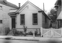
House on site affected by the construction of the Crosstown. Address: 10 Kennedy Street. Surveyor notations on back of photo: "Dkt.: 10.524. Property owner: Lucille Beall. Tract: 93. Station: 81+50 CL. Date: Dec. 1, 1964. In R/W - Bought." [See collection description for explanation of surveyor notations.]
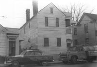
House on site affected by the construction of the Crosstown. Address: 167 Line Street. Surveyor notations on back of photo: "Dkt.: 10.524. Property owner: C.F. Pequette, Est. Tract: 91. Station: 81+15 Lt. Date: Dec. 1, 1964." [See collection description for explanation of surveyor notations.]
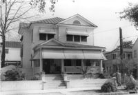
House on site affected by the construction of the Crosstown. Address: 270 Ashley Avenue. Surveyor notations on back of photo: "Dkt.: 10.524. Property owner: J. Arthur Brown. Tract: 90. Station: 80+50 Lt. Date: Dec. 1, 1964." [See collection description for explanation of surveyor notations.]
House (rear view) on site affected by the 167 Line Street. Surveyor notations on back of photo: "Dkt.: 10.524. Property owner: C.F. Pequette, Est. Tract: 91. Station: 81+15 Lt. Date: Dec. 1, 1964." [See collection description for explanation of surveyor notations.]
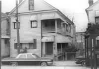
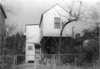
House (freedman's cottage) on site affected by the construction of the Crosstown. Address: 118 Bogard Street. Surveyor notations on back of photo: "Dkt.: 10.524. Property owner: Marion Holmes Wright, Est., et al. Tract: 62. Station: 75+10 CL Lt. Date: Oct. 14, 1964. Partially in R/W." [See collection description for explanation of surveyor notations.]