Search
« Previous |
1 - 100 of 255
|
Next »
Search Results
Description:
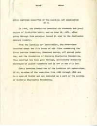
Description and index of Civic Services Committee materials that were taken from Carolina Art Association and incorporated into the files of what became Historic Charleston Foundation. Also includes a list of materials "now on deposit at SC Historical Society," and the finding aid to the Civic Services Committee records that are still held at the Gibbes Museum of Art.
Description:
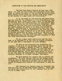
Report entitled "Objectives of the Carolina Art Association."
Description:
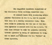
Document regarding the objectives of the Civic Services Committee.
Description:
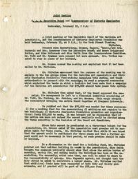
A joint meeting report for the C.A.A executive board and Incorporators of Historic Charleston (Feb. 19).
Description:
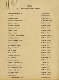
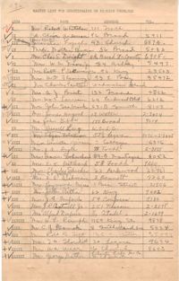
Membership list of the Charleston Real Estate Exchange.
Description:
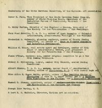
Membership list for the Civic Services Committee of the Carolina Art Association.
Description:
Ex-Officio membership list for the Civic Services Committee.
Description:
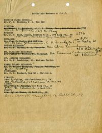
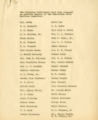
List of individuals proposed to become members of the Charleston Civic Services Committee.
Description:
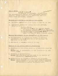
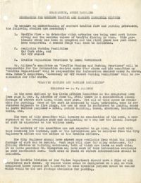
Outline (draft) describing the aim of the architectural survey, elements contributing to the loss of buildings, elements contributing to the preservation of historic buildings, features of the present trend of preservation, the inventory procedure, zoning, legal aspects, and financial aspects of preservation.
Description:
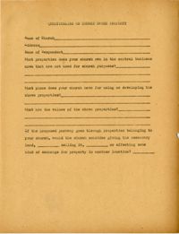
Blank questionnaire on church owned property.
Description:
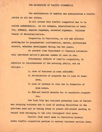
One version of document entitled "The Background of Traffic Congestion," by Henry P. Staats regarding traffic congestion in America including Charleston and New York City.
Description:
Memorandum for guiding traffic and parking for the committee on "Traffic Studies and Parking Practices," chaired by A.W. Allison.
Description:
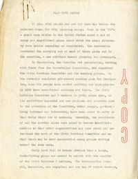
A speech entitled "Plan with People."
Description:
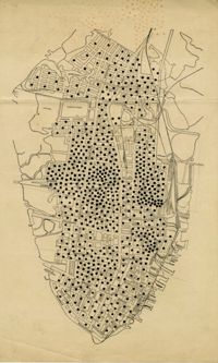
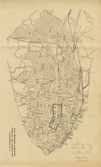
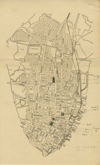
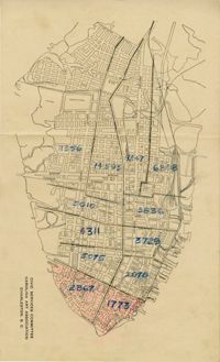
Map of peninsula.
Description:
Notes from "Permanent Recreation Areas in Real Estate Developments" by Mary Beattie Brady.
Description:
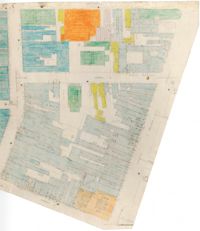
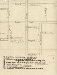
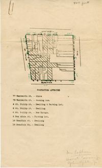
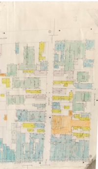
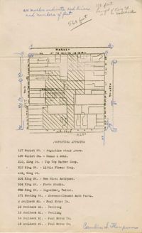
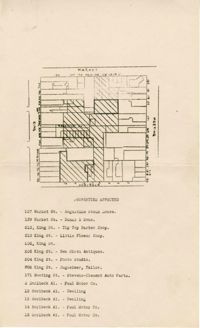
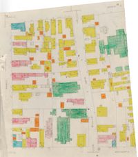
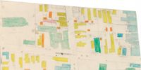
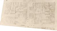
Color-coded map of area bounded by Wentworth Street, Meeting Street, Market Street, and King Street.
Description:
Disposition by the Community Development Council of two listener suggestions regarding the provision on trailer park camps.
Description:
Business questionnaire for "Charleston Grows."
Description:
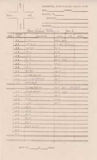
Document listing the number and size of prints of photographs.
Description:
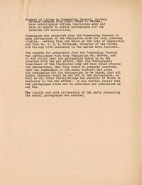
Document summarizing a letter to the Commanding General, Eastern Defense Command, from Captain James F. Reeves regarding the use of photographs of the Charleston area for the exhibit.
Description:
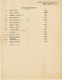
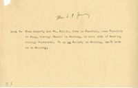
Attendance list for a CSC meeting on June 9 [1949].
Description:
A speech entitled "Off Street Parking."
Description:
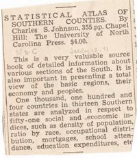
Newspaper clipping regarding the "Statistical Atlas of Southern Counties" by Charles S. Johnson.
Description:
Traffic count papers for Charleston, SC, with tally marks on them.
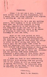
Description:
Comments of Mary E. McDonald regarding parking in Charleston.
Description:
Blank index card for sponsor contact information.
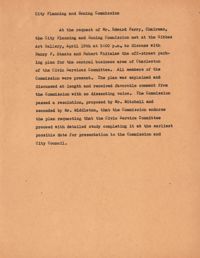
Description:
Report on a meeting with the City Planning and Zoning Commission.
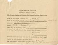
Description:
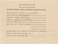
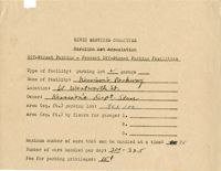
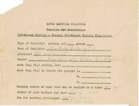
Off-street parking facilities survey filled out for Auto Livery Co. (Connelley's Storage Garage).
Description:
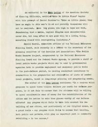
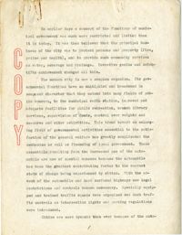
A document that addresses the need for city planning and historic preservation in Charleston and about the work of the Planning Committee of the Carolina Art Association. (May be an editorial.)
Description:
Notes regarding area 7 of the off-street parking facilities survey.
Description:
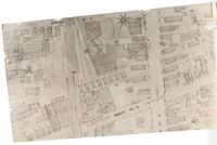
Map of Area 11of the off-street parking facilities survey.
Description:
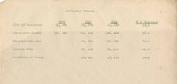
Document on population figures.
Description:
The master list for the questionnaire on parking problems, listing area number, name, address, and telephone number.
Description:
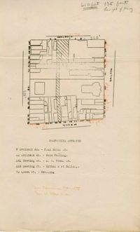
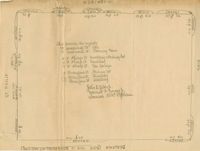
Map of area bounded by Beaufain, St. Philip, Wentworth, and King Street.
Description:
Map of area bounded by Wentworth, King, Liberty, and St. Philip Street.
Description:
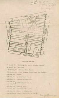
Map of area bounded by Archdale, Market, King and Beaufain Streets.
Description:
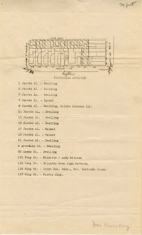
Map of area bounded by Jacob's Alley, Queen, King, and Archdale Street.
Description:
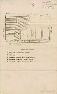
Map of area bounded by Burns Lane, Meeting, Calhoun, and King Street.
Description:
Map of peninsula.
Description:
Map of peninsula.
Description:
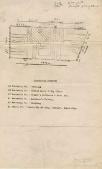
Map of area bounded by Wentworth, Meeting, and Hasell Street.
Description:
Map of area bounded by Horlbeck Alley, Meeting, and Queen Street.
Description:
Map of peninsula.
Description:
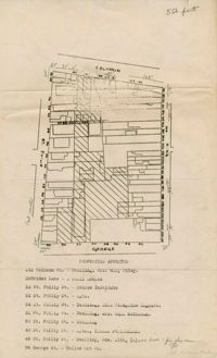
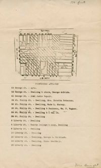
Map of area bounded by George, King, Calhoun, and St. Philip Street.
Description:
Map of area bounded by Wentworth, King, Beaufain, and St. Philip Street.
Description:
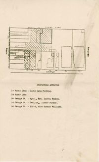
Map of area bounded by Burns Lane, George, Meeting, and King Street.
Description:
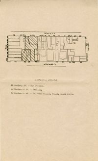
Map of area bounded by Society, Meeting, Wentworth, and King Street.
Description:
Color-coded map of area between Society Street and Wentworth Street at Meeting Street..
Description:
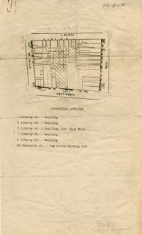
Map of area bounded by Liberty, King, George, and St. Philip Street.
Description:
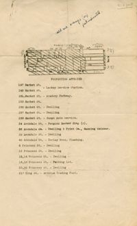
Map of area bounded by Hasell, Meeting, King and Market Street.
Description:
Map of area bounded by Horlbeck Alley, King, Market, and Meeting Street.
Description:
Map of area bounded by Society, Meeting, George, and King Street.
Description:
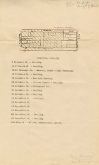
Map of area bounded by Market, King, Princess, and Archdale Street.
Description:
Map of area bounded by Jacob's Alley, Archdale, Clifford, and King Street.
Description:
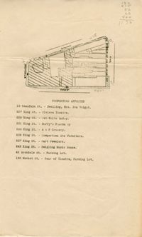
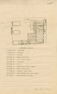
Map of area bounded by Clifford, King, Beresford, and Archdale Street.
Description:
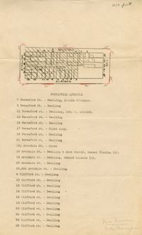
Map of area bounded by Princess, King, Beresford, and Archdale Street.
Description:
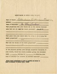
Church owned property questionnaire filled out for St. Andrew's Lutheran Church.
Description:
Map of area bounded by Market Street, Meeting Street, Horlbeck Street, and King Street.
Description:
Off-street parking facilities survey filled out for Al--cida on 396 Meeting Street.
Description:
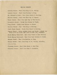
Document listing one way streets.
Description:
Color-coded map of area bounded by Wentworth Street, Coming Street, George Street, and Glebe Street.
Description:
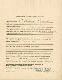
Church owned property questionnaire filled out for St. Phillip's Church.
Description:
Map of area bounded by Society Street, Meeting Street, Wentworth Street, and King Street.
Description:
Off-street parking facilities survey filled out for Shell Service Station.
Description:
Map of area bounded by George Street, King Street, Burns Lane, and Meeting Street.
Description:
Off-street parking facilities survey filled out for Firestone Service Station.
Description:
Color-coded map of area near where Market Street and Beaufain Street meet..
Description:
Off-street parking facilities survey filled out for Taud M. Esso Station.
Description:
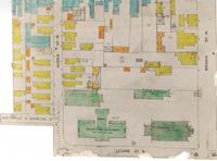
Color-coded map of area bounded by Broad Street, Legare Street, and Queen Street.
Description:
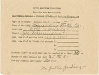
Off-street parking facilities survey filled out for Misereudino Motor Co.
Description:
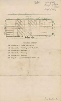
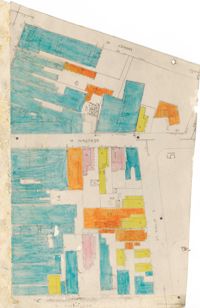
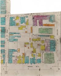
Color-coded map of area bounded by Meeting Street, Broad Street, Queen Street, and King Street.
Description:
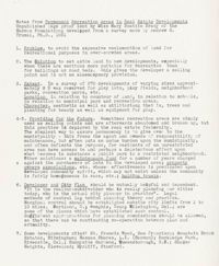
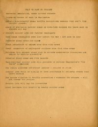
Key points related to city planning, of "what we want to present."
Description:
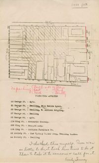
Map (not color-coded) of area around Reid Street and Meeting Street
Description:
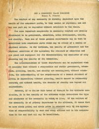
A speech entitled "How a Community Plans Together."
Description:
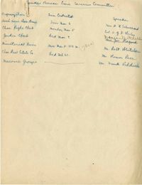
List of speaking engagement assignments
Description:
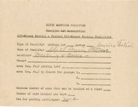
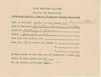
Off-street parking facilities survey filled out for Kennison's Parkway.
Description:
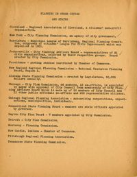
Key points and notes related to "Planning in Other Cities and States."
Description:
Color-coded map of area around Vanderhorst Street, near a police station and St. Paul's Episcopal Church.
Description:
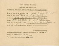
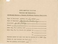
Off-street parking facilities survey filled out for Brown's Parkway.
Description:
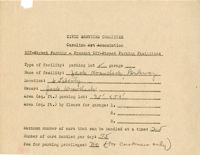
Off-street parking facilities survey filled out for Jack Krawcheck Parkway.
Description:
Map (not color-coded) of area between Cannon Street ad Spring Street
Description:
Map (not color-coded) of area around Woolfe Street at the Southern Ice Co.
Description:
Off-street parking facilities survey filled out for Charleston Parking Lot on 80 Wentworth Street.
Description:
Notes from "The New Exploration" by Benton MacKaye.
Description:
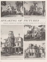
Clipping "These American Gothic Houses were Fun to Live In," featuring photographs of American Gothic houses in Massachusetts, Vermont, and New Hampshire.
Description:
Notes on "The Regional Planning of Banbury and District."
Description:
Notes from "Housing for the Machine Age" by Clarence Arthur Perry.
Description:
Notes on "How to Promote Community and Industrial Development" by Frederick H. McDonald.
Description:
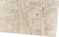
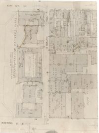
Map (not color-coded) of area between King Street and Meeting Street at Hutson Street (SC Military Academy).
Description:
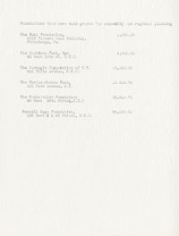
Document listing foundations that have made grants for community and regional planning.
Description:
Notes on preservation of historic buildings in England lecture by Mr. Underwood.
Description:
Notes from "Regional and Town Planning" by W.H. McLean.
Description:
Off-street parking facilities survey filled out for George Street Parkway.
Description:
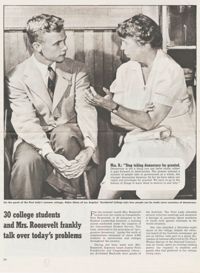
Clipping of article entitled "30 College students and Mrs. Roosevelt frankly talk over today's problems."
Description:
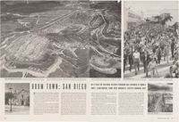
Clipping "Boom Town: San Diego."
Description:
Notes from "City Planning, Why and How" by Harold MacLean Lewis.
Description:
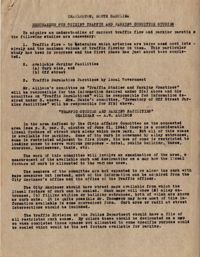
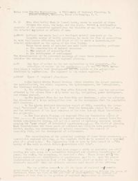
Memorandum, Guiding Traffic and Parking Committee Studies in Charleston, SC.
Description:
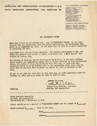
Letter from Robert Whitelaw soliciting sponsorship for "Charleston Grows."