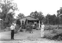
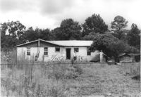
House on site affected by the construction of Interstate 26 (I-26). Surveyor notations on back of photo: "Dkt.: 10.471. Property owner: J.E. Walling. Tract: 41. Station: 5325+15 Rt. Date: Aug. 23, 1960. In R/W - Bought." [See collection description for explanation of surveyor notations.]
House on site affected by the construction of Interstate 26 (I-26). Surveyor notations on back of photo: "Dkt.: 10.471. Property owner: M.L. Shipman, et al. Tract: 42. Station: 5326+75 Rt. Date: Aug. 23, 1960. Proximity." [See collection description for explanation of surveyor notations.]
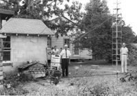
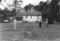
House on site affected by the construction of Interstate 26 (I-26). Surveyor notations on back of photo: "Dkt.: 10.471. Property owner: W.W. Gregory. Tract: 46. Station: 5329+60 Rt. Date: Aug. 23, 1960. Proximity." [See collection description for explanation of surveyor notations.]
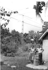
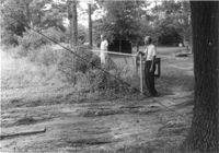
Lot with tall mast, on site affected by the construction of Interstate 26 (I-26). Surveyor notations on back of photo: "Dkt.: 10.471. Property owner: W.W. Gregory. Tract: 46. Station: 5330+00 Rt. Date: Aug. 23, 1960. Owner to move mast." [See collection description for explanation of surveyor notations.]
House (rear view) and outbuildings on site affected by the construction of Interstate 26 (I-26). Surveyor notations on back of photo: "Dkt.: 10.471. Property owner: Susie O. Morris. Tract: 76. Station: 5358+50 Rt. Date: Aug. 23, 1960. Proximity." [See collection description for explanation of surveyor notations.]
House (rear view) on site affected by the construction of Interstate 26 (I-26). Surveyor notations on back of photo: "Dkt.: 10.471. Property owner: George Brown. Tract: 77. Station:5362+80 Lt. Date: Aug. 23, 1960. Proximity to house. Bought well house." [See collection description for explanation of surveyor notations.]
House on site affected by the construction of Interstate 26 (I-26). Surveyor notations on back of photo: "Dkt.: 10.471. Property owner: Annie L. Beattie. Tract: 83. Station: 5364+00 Rt. Date: Aug. 23, 1960. In R/W - Bought." [See collection description for explanation of surveyor notations.]
House on site affected by the construction of Interstate 26 (I-26). Surveyor notations on back of photo: "Dkt.: 10.471. Property owner: A.R. Hopkins. Tract: 87. Station: 5366+60 Rt. Date: Aug. 23, 1960. Proximity." [See collection description for explanation of surveyor notations.]
Property on site affected by the construction of Interstate 26 (I-26). Surveyor notations on back of photo: "Dkt.: 10.471. Property owner: Douglas E. Bohler, et al. Tract: 90. Station: 5374+20 to 5377+00 Lt. Date: Aug. 23, 1960. In R/W - Bought." [See collection description for explanation of surveyor notations.]
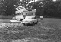
Mobile home and lot, on site affected by the construction of Interstate 26 (I-26). Surveyor notations on back of photo: "Dkt.: 10.471. Property owner: Douglas E. Bohler, et al. Tract: 90. Station: 5376± Lt. Date: Aug. 23, 1960. In R/W - Bought." [See collection description for explanation of surveyor notations.]
Limit your search
SCDOT Photographs: Properties in the Right-of-Way✖[remove]79