Bowman Plat 1843
Close Viewer
- Title:
- Bowman Plat 1843
- Date:
- 1843
- Description:
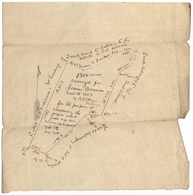
- 1300 acres surveyed for James Bowman, no land type or detail, shows property boundaries and neighboring plots. Names associated with this plat are James Bowman, Morris, Oswald, Warley, E.B. Fishburn, Lindsey, and B.G.O. Bryan. Notable geographic locations include New road leading to Parkers Ferry [?].
- Collection Title:
- John McCrady Plats and Deeds Collection
- Contributing Institution:
- South Carolina Historical Society
- Media Type:
- Maps
- Topical Subject:
- Conveyancing--South Carolina, Maps, and Surveying--South Carolina
- Language:
- English
- Shelving Locator:
- 510.00, Box 3, Folder 105
- Date Digital:
- 2018-09-27
- Digitization Specifications:
- 400 dpi, 24-bit depth, color, Bookeye 4 Basic, Archival masters are tiffs.
- Internet Media Type:
- image/jpeg
- Copyright Status Statement:
- Public Domain.
- Access Information:
- For more information and re-use requirements contact the South Carolina Historical Society, Charleston, SC, 29401.
- Admin ID:
- 223369
Permalink