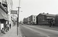
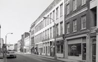
Black-and-white photograph of the view south on Meeting Street from 242 Meeting, showing Anderson Electric Co. (246 Meeting) at right and the Best Western King Charles Hotel (237 Meeting) at left.
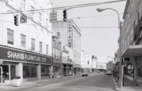
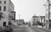
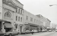
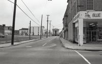
Black-and-white photograph of the view south on King Street from Wentworth Street, showing 270 King (Shahid's Furniture City) (left) and 273 King Street (right) down to approximately 240 King. Diana Shops (264 King) and Kerrison's building (260 King) also in view.
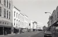
Black-and-white photograph of the view south on King Street from 260 King Street (Kerrison's building) down to approximately 240 King. Snelgrove’s dress shop (258 King) and Daisy Bogin dress shop (256 King), and the corner of Hasell Street are also in view.
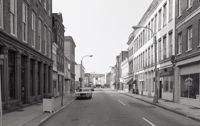
Black-and-white photograph of the view north on King Street showing the east side of King Street from 190 King Street (right) and 191 King Street (left). Kerrison's building in the background.
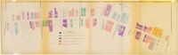
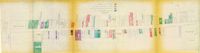
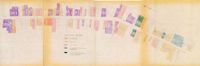
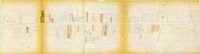
One of four maps of King Street building footprints, hand-colored to designate status. This map illustrates the historical significance of buildings on King Street from Calhoun Street to Queen Street.
Looking north on Church Street from Chalmers Street. Features buildings on the west side of the street: 127 Church, 129 Church, 131 Church, and the Dock Street Theater). Also in view are buildings on the east side of the street: 18 Chalmers Street, 132 Church Street, and St. Philip's Church). Cars are parked on the street.
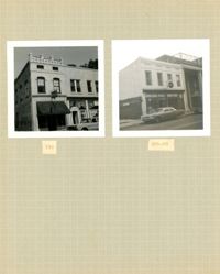
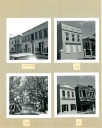
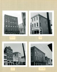
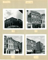
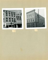
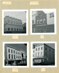
Two B&W photographs of buildings on the west side of King Street: Left (159-161): 159 King Street (Hildebrands) and 161 King Street; Right (201-203): 201 King Street (Castanes Grocery) and 203 King Street (later demolished for the construction of Victoria Center).
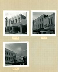
Three B&W photographs of buildings on the west side of King Street: Top left (337-339): 337 King Street (King's Restaurant) and 339 King Street (Fox Hi-Fi); Top right (331-335): 331 King Street, 333 King Street, and 335 King Street (Lesser-Tanenbaum); Bottom left (327-329): 327 King Street (Barton's Candy Card & Gift Shop) and 329 (Gloria Theater).
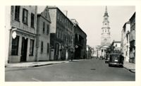
Black-and-white photograph of the view north on King Street showing the east side of King Street from 190 King Street (Home Appliance & Service Co.). Kerrison's building in background.
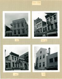
Four B&W photographs of buildings on the west side of King Street: Top left: 381 King Street (Felder's Rexall Drugs); Top right (367-369): 367 (Convertino's One Hour Cleaning) and 369 King Street (Lesser's Credit Jewelers); Bottom left (369-371): 369 King Street (Lesser's Credit Jewelers) and upper left portion of 371 King Street; Bottom right (341-343): 341 King Street (C.W. Kessler's) and 343 King Street (Askew's Clothiers).
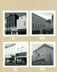
Four B&W photographs of buildings on the east side of King Street: Top left (340-342): 340 King Street (Charlie Gilik Tailor Shop) and 342 King Street (Dior's Wigs); Top right (334-338): 334 King Street (Elza's), 336 King Street, and 338 King Street; Bottom left (330-334): 330-332 King Street (Clement Furniture Co.) and 334 King Street (Elza's); Bottom right: 330-332 King Street (Clement Furniture Company).
Four B&W photographs of buildings on the east side of King Street: Top left (368-370): 368 King Street (Club 400) (demolished for parking lot) and 270 King Street (World Finance Corp.); Top right: 362-364 King Street (Kaybee); Bottom left (354-356): 354 King Street and 356 King Street (White House Grocery); Bottom right (344-348): 344 King Street (Clark Clothier), 346 King Street, and 348 King Street (American Arcade - American Mortgage Co.)
Black-and-white photograph of the view east on Market Street from near the intersection of Archdale Street. Market Hall in the distance. Goodyear building at left; 40 Archdale Street at right.
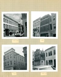
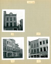
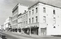
Four B&W photographs of buildings on the east side of King Street: Top left (178-184): 178 King Street (W.K. Prause Co.), 180 King Street, 182 King Street, and 184 King Street; Top right: 174 King Street; Bottom left: 164 King Street (Charleston Library Society) [labeled 168 on album page]; Bottom right (160-162): 160 King Street and 162 King Street.
Four B&W photographs of buildings on the west side of King Street: Top left (181-183): 181 King Street (Jack Patla Antiques) and 183 King Street (The Art Shop); Top right (175-179): 175 King Street, 177 King Street, and 179 King Street (Fralix & Sons); Bottom left (169-173): 169 King Street (R.M. McGillivray's) and 171-173 King Street; Bottom right (165-169); 165 King Street and 169 King Street (R.M. McGillivray's).
View looking east on Market Street from the junction of King Street and Market, showing the parking lot where Belk Department Store once was (left) and 220 King Street (Blue Knight Gallery) (right) down to Market Hall (distance). Meeting Street elevation of the Arnold-Hornik Building (112 North Market) also in distance. "Sold" sign on fence surrounding the lot, which is now the site of Charleston Place / Charleston Center.
Four B&W photographs of buildings on the east side of King Street: Top left (188-200): 188 King Street (Installment Finance Co. Loans), 190 King Street, and 192-200 King Street (Hoffman House); Top right (188-190): Edge of 188 King Street (Installment Finance Co. Loans) and 190 King Street (Home Appliances and Service Co.); Bottom left: 188 King Street (Installment Finance Co.); Bottom right (184-186): 184 King Street (Dinty Moore's) and 186 King Street.
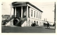
Black-and-white photograph of Market Hall (188 Meeting Street) and the view east on South Market Street showing the Market sheds. Corner of North Market Street also in view.
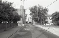
Black-and-white photograph of the view east on Hasell Street from the C. B. Prentiss & Co. Customer Parking Lot and 95 Hasell Street (St. Mary’s Roman Catholic Church). 87 Hasell and 85 Hasell also in view at left.
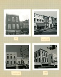
Four B&W photographs of buildings on the west side of King Street, including 213 King and 215 King, demolished for the construction of Majestic Square: Top left (211-215): 211-213 King (Palmetto Hotel) and 215 King Street (Stephan's); Top right: 197 King Street; Bottom left 193-197: 193 King Street (Colonial Antique Shop), 195 King Street, and 197 King Street; Bottom right (191-197): 191 King Street (Birlant Antiques), 193 King Street, 195 King Street, 197 King Street.
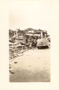
Looking east on Market Street after the tornadoes of September 29, 1938, showing the Market Sheds in ruins. A damaged car is parked along side of the debris. The Old Church of the Redeemer can be seen in the background.
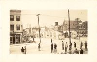
Looking northwest on Market Street from the U.S. Custom House on East Bay Street, after the tornadoes of September 29, 1938, showing damaged and ruined Market Sheds. Also shows the damaged buildings on North Market Street. Onlookers and cars are in the street. Partial view of ca. 225 East Bay Street (now gone) is on the left.
Looking north on Church Street from the northeast corner of Chalmers Street. Features buildings on the west side of the street: 129 Church, 131 Church, and the Dock Street Theater). Also in view are buildings on the east side of the street: 18 Chalmers Street, 132 Church Street, and St. Philip's Church). Cars are parked on the street.
One of four maps of King Street building footprints, hand-colored to designate status. This map illustrates the historical significance of buildings on King Street from Calhoun Street to Columbus Street.
Black-and-white photograph of the view north on Meeting Street toward Market Street, from the 135 Meeting (Gibbes Art Gallery) and 141 Meeting (Charleston Gas Light Co. Building) at left.
Four B&W photographs of buildings on the east side of King Street: Top left: 220 King Street (Dumas); Top right: 218 King Street (Sharnoff's Uniform Shop); Bottom left (212-218): 212 King Street, 214 King Street (Fabric Center), 216 King Street, and edge of 218 King Street; Bottom right (208-214): 208 King Street (Gatlin Opticians), 212 King Street (La Scaltro Antiques), and 214 King Street (Fabric Center).
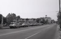
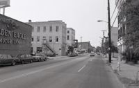
Black-and-white photograph of the view north on Meeting Street toward Market Street, from the parking lot of the White Horse Inn. The Golden Eagle Motor Inn next door is also in view.
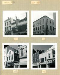
Three B&W photographs of buildings on the west side of King Street, demolished for the construction of Majestic Square: Top left: 223 King Street (Ocean Grill); Top right: 221 King Street (photograph is missing); Bottom left (219-223): 219 King Street (Rice Bros.), 221 King Street, and 223 King Street (Ocean Grill); Bottom right (217-219): 217 King Street and 219 King Street (Rice Bros.).
Black-and-white photograph of the view north on Meeting Street toward Market Street, from the Golden Eagle Motor Inn. Madren Paint Co. (177 Meeting) also in view.
Two B&W photographs of buildings on the east side of King Street, both demolished for the construction of Charleston Place: Left (224-226): 224 King Street and 226 King Street (Ritz Hotel); Right: 222 King Street (Copa Lounge) (northeast corner of King and Market).
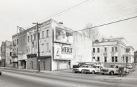
Four B&W photographs of buildings on the east side of King Street, including some that were demolished for the construction of Charleston Place: Top left (244-246): 244 Coastal Finance Loans and 246 King Street (The Linen Shop) demolished; Top right: 238-242 King Street (J.C. Penney Company) ? demolished; Bottom left (226-230): 226 King Street (Ritz [Hotel]), 228 King Street (Little Town), and 230 King Street demolished; Bottom right: 316 King Street (Rosalie Meyers) [labeled 318 on album page].
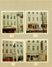
Four color photographs of buildings on the west side of King Street: Top left: 235 King Street (Interiors); Top right: 233 King Street; Bottom left: 231 King Street (The Tiki); Bottom right: 229 King Street (Old Towne Restaurant)
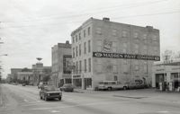
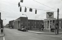
Black-and-white photograph of the view north from the intersection of Meeting Street and Market Street. Madren Paint Co. (177 Meeting) at left; First Citizens Bank (182 Meeting), Market Hall, and 112 North Market at right.
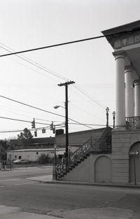
Black-and-white photograph of the northwest elevation of 235 Meeting Street. Shows the corner of Meeting and Hasell Streets and the north elevation of the building that extends west on Hasell Street. "Picture Framing" signage over window. Also shows neighboring buildings to the south in the view down Meeting. (Currently the site of Sticky Fingers Restaurant.)
Black-and-white photograph of the view from the parking lot of First Citizens Bank (182 Meeting) to the northwest corner of Meeting and Market. South elevation of Market Hall at right.
Four B&W photographs of buildings on the west side of King Street: Top left: 273 King Street (Mary Jane Shoe Store); Top right (263-267): 263 King Street (Legerton's), 265 King Street (Scottie Stores), and 267 King Street (Warner's); Bottom left (251-253): 251 King Street (Adams and Ortmann) and -253 King Street; Bottom right (243-245): 243 King Street (Siegling's) and 245 King Street (Silver 5 & 10 & 1.00 Store).
Black-and-white photograph of the view northwest from the corner of Market and Meeting Streets to the northwest corner of Meeting and Market. Columns and stairs to Market Hall in foreground.
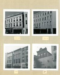
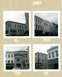
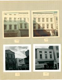
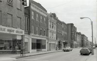
Four B&W photographs of buildings on the east side of King Street: Top left: 270-274 (Walgreens); Top right: 268 (McIntosh's); Bottom left (256-258): 256 King Street (Daisy Bogin) and 258 King Street (Snelgrove's); Bottom right: 254 King Street (Household Finance Co.)
Four photographs of buildings on the east side of King Street (both color and B&W): Top left: 290 King Street (Annette's Blue Gown) (color photograph); Top right: 286 King Street (Hunley's Drugs) (color photograph); Bottom left (282-284): 282 King Street (Raley's Cafeteria) and 284 King Street (Citizens & Southern National Bank) (B&W photograph); Bottom right: 278 King Street (French Boot Shop) (B&W photograph).
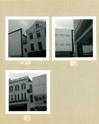
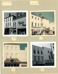
Three B&W photographs of buildings on the west side of King Street: Top left (295-297) 295 King Street (Friedman's) and 297 King Street (National Shirt Shop); Top right: 293 King Street (Hanover); Bottom left (285-287): 285 King Street (Charles Kerrison & Co.) and 287 King Street (Butler's Shoes).
Four photographs of buildings on the east side of King Street (both color and B&W): Top left (316-320): 316 King Street (316-Rosalie Meyers) and 320 King Street (Evelyn Rubin); Top right (304-308): 304 King Street (Leroy's Jewelry Co.), 306 King Street (China Hall) and 308 King Street (Croghan's Jewel Box/The New Shoe Factory) (color photograph); Bottom left: 306 King Street (China Hall) (color photograph); Bottom right (294-296): 294 King Street (Haverty's) and 296 King Street (Levy's) (B&W photograph).
Three B&W photographs and one color photograph of buildings on the west side of King Street: Top left (319-325): 319 King Street (Bob Ellis Shoe Store), 321 King Street, 323 King Street (LeRoy's Jewelry Co.), and 325 King Street (Thom McAn); Top right: 315 King Street (Jean Meyers); Bottom left: 309-311 King Street (color photograph); Bottom right: 297 King Street (National Shirt Shop) (Arcade Theater sign on corner of building).
One of four maps of King Street building footprints, hand-colored to designate status. This map illustrates proposed reuses of buildings on King Street from Calhoun Street to Queen Street.
One of four maps of King Street building footprints, hand-colored to designate status. This map illustrates area conditions of buildings on King Street from Calhoun Street to Columbus Street.
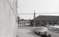
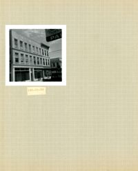
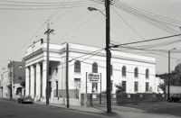
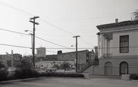
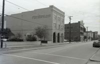
Black-and-white photograph of the east side of the 240 block of Meeting Street, from a parking lot at the corner of Meeting and Hasell Streets and showing 246 Meeting Street (Anderson Electric Co.). 248 Meeting, 250 Meeting, and 252 Meeting. Southwest elevations of 66 Hasell Street and 64 Hasell Street visible at right. (246-250 Meeting is currently a parking lot.)
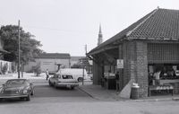
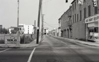
Black-and-white photograph of the east side of the 250 block of King Street, looking north from Hasell Street, starting at 254 King Street, showing 256 King Street, 258 King Street, 260 King Street, and beyond.
Black-and-white photograph of the west side of the 250 block of King Street, looking north, starting at 253 King Street, and showing 255 King Street, 257 King Street, 259 King Street, 265 King Street, and beyond.
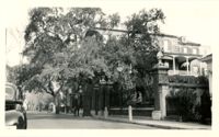
Looking north on East Battery Street from near the bend at White Point Gardens. Pedestrian is walking by White Point Gardens. Louis Desaussure House (1 East Battery) at center; Missroon House (40 East Bay Street) in the distance.
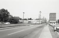
Black-and-white photograph of the west side of the 170 block of Meeting Street, looking south from the corner of Market Street. Shows Parson's Gulf Station (181-183 Meeting), Madren Paint Company (177 Meeting Street, 173 Meeting Street, and the Golden Eagle Motor Inn. (Currently the site of the Wells Fargo Banking Center.)
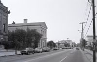
Black-and-white photograph of the view of the east side of King Street, looking south from Market Street, from 220 King Street to about 186 King Street. Shows 220 King, 218 King, 216 King, 214 King, 212 King, 210 King, 208 King, 206 King, 204 King, 202 King, 200 King, 188 King, 186 King.
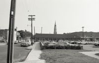
Black-and-white photograph of the east side of Meeting Street looking south to from Market Street down to Cumberland Street. Shows 182 Meeting Street (First Citizens Bank), 172 Meeting Street, and other buildings since demolished.
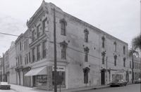
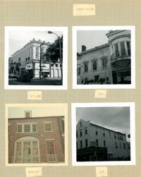
Black-and-white photograph of the west side of King Street below Market Street, starting from the southwest corner of King Street and Market Street. South Carolina Federal Savings & Loan (221 King Street) in foreground. Also shown are 219 King Street, 217 King Street, 215 King Street, and 213 King Street. (Currently the site of Majestic Square.)
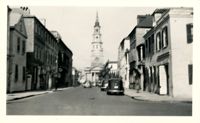
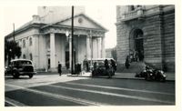
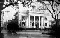
View of the intersection of Broad and Meeting Streets, featuring the Federal Courthouse and Post Office and St. Michael's Church. A car, motorcycle, and bus are on the street the street. Also shows pedestrian activity.
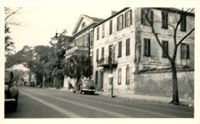
Looking west on Broad Street at 110 Broad Street (Bishop Northrop residence a/k/a William Harvey House a/k/a Ralph Izard House) and 114 Broad Street (Col. Thomas Pinckney House). Cars parked along the street.
Photographs taken by Sabina Elliott Wells in 1898-1899. Wells was a Charleston artist and designer; she was also a Newcomb potter. Photographs include scenes in Charleston and the Lowcountry, in northwest South Carolina (Table Rock and vicinity), and in western North Carolina (Flat Rock and vicinity). Scans were derived from negatives donated to Historic Charleston Foundation. (Note: Wells's diaries from 1898-1899 that document some of her travels, including sites represented in these photographs, are at the South Carolina Historical Society, "Sabina E. Wells papers, 1886-1942.")
Black-and-white photograph of the view looking east on Market Street at the junction of King and Market Streets, from what was the location of Belk Department Store and parking lot (left) and 220 King Street (Blue Knight Gallery) (right) down to Market Hall (background). Meeting Street elevation of the Arnold-Hornik Building (112 North Market) also in view. Vacant lot is now the site of Charleston Place / Charleston Center.
View of Market Hall, southwest elevation, including market sheds, and the corner of Market and Meeting Streets. Cars on street and pedestrian crossing the street. Cravens Delco Radio [store] on North Market Street at left.
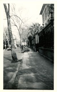
Looking north on Legare Street at 22 Legare Street (Charles Elliott House), a portion of which can be seen in the foreground (right). Man gathering leaves on the sidewalk. Car parked in background.
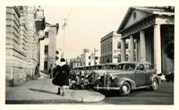
Scene on Meeting Street just south of the "Four Corners of Law" on Broad Street. Features the Federal Courthouse and Post Office and St. Michael's Church in foreground, and the County Courthouse and City Hall in background. Numerous cars are parked in front of the Federal Courthouse, with pedestrians on the sidewalk.
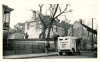
Looking west on Tradd Street at the outbuildings of 32 Legare Street (Sword Gate House). West End Dairy truck parked on street. Pedestrian on sidewalk and person riding a bike on street.