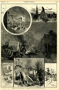
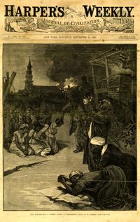
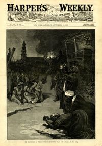
Main caption: 'Incidents of the Earthquake at Charleston.--drawn by Schell and Hogan.--[see page 590.]' Caption top left: 'In front of the Charleston Hotel.' Caption top right: 'looking over the roofs.' Caption middle: 'A camp on the East Battery.' Caption bottom left: 'The front wall gone.' Caption bottom center: 'In a rich man's garden.' Caption bottom right: ' On the track.' [full date September 11, 1886.]
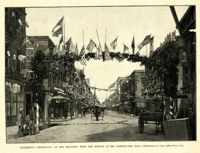
Caption: 'Charleston--Celebration of her recovery from the effects of the Earthquake.--from a photograph by Cook.--[see page 818.]' [full date November 12, 1887.]
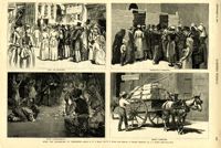
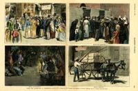
Caption: 'After The Earthquake At Charleston.--drawn by W.A. Rogers and W.P. Snyder from sketches by Frederic Remington and A.J. Gustin.--[see page 610.]' Individual captions: (top left): 'Open air preaching.' (top right): Subsistence committee.' (bottom left): 'Negro prayer-meeting.' (bottom right): 'Relief committee.' [full date September 18, 1886.]
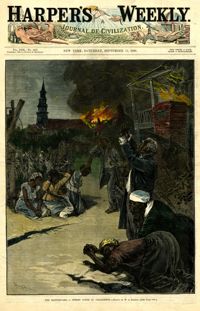
[Color image.] Main caption: 'After the Earthquake at Charleston.--drawn by W.A. Rogers and W.P. Snyder from sketches by Frederic Remington and A.J. Gustin.--[see page 610.]' Caption upper left: 'Open air preaching.' Caption upper right: 'Subsistence Committee.' Caption lower left: 'Negro prayer-meeting.' Caption lower right: 'Relief committee.' [full date September 18, 1886.]
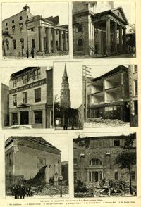
Caption: 'The Ruins Of Charleston.--photographed by W.E. Wilson, Savannah, Georgia. 1. The Guard House. 2. St. Michael's Church. 3. News and Courier Office. 4. St. Philip's Church. 5. No.27 Broad Street. 6. Hibernian Hall. 7. The Medical College.'
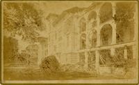
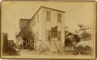
Caption: 'Cook's Earthquake Views of Charleston and Vicinity. Series No.2. No.182, Porch of Lazarus House.' Hassell Street. Charleston city directory for 1886 shows Mrs. B.D. Lazarus at 64 Hassell Street.
Caption: 'Cook's Earthquake Views of Charleston and Vicinity. Taken after the 31st of August, 1886. No.61, Mrs. B.D. Lazarus, Hasel [sic] St.' Charleston city directory for 1886 shows Mrs. B.D. Lazarus at 64 Hassell Street.
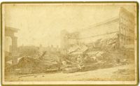
Caption: 'Cook's Earthquake Views of Charleston and Vicinity. Taken after the 31st of August, 1886. No.27, Hayne Street - ruins of three large buildings.' Sign on column at left reads: 'Charleston Bag Factory.' Charleston city directory for 1886 shows a bag factory at 15-19 Hayne Street.
Charleston Earthquake scene. Written on front, at bottom: 'Sailor's Home, Charleston, S.C. after the Earthquake.' Sign at top of building reads: 'Charleston Port Society.'
Charleston Earthquake scene. Labeled 'Old Hospital' in lower left corner, with 'Trapman Street' handwritten at bottom, front. Additional note on reverse: 'See Cook No.189 [from Series 2, which is captioned as 'Ruins of Colored hospital.']
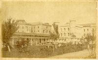
Caption: 'Cook's Earthquake Views of Charleston and Vicinity. Taken after the 31st of August, 1886. No.4, Roper Hospital.' Shows Roper Hospital when at Queen Street location.
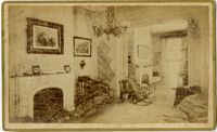
Caption: 'Cook's Earthquake Views of Charleston and Vicinity. Taken after the 31st of August, 1886. No.70, E.B. Hume, Legare Street.' Charleston city directory for 1886 shows Errington B. Hume at 17 Legare Street.
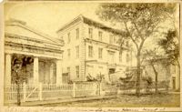
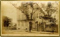
Caption: 'Cook's Earthquake Views of Charleston and Vicinity. Taken after the 31st of August, 1886. No.114, residence Col. Inglesby.' Charleston city directory for 1886 shows Charles Inglesby at 20 Meeting Street.
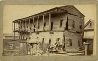
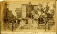
Caption: 'Cook's Earthquake Views of Charleston and Vicinity. Taken after the 31st of August, 1886. No.60, J.M. Wilson, Meeting St.' Charleston city directory for 1886 shows James M. Wilson at 39 Meeting Street.