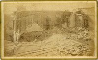
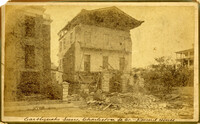
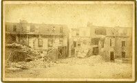
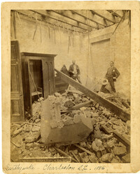
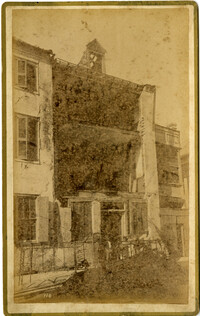
Caption: 'Cook's Earthquake Views of Charleston and Vicinity. Taken after the 31st of August, 1886. No.116, wreck in George Street.' Written on front, at bottom: 'Charleston Earthquake view - Ruins in George St.'
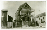
Written on reverse: 'House in which young Mr. Robson was killed. Two young ladies were buried in the ruins were rescued. Coming near Cannon.' Possibly from Cook's Earthquake Views, No.132, residence of J.N. Robson, from west. Written on front, at bottom: 'Charleston Earthquake view. Residence of Mr. J.N. Robson, whose eldest son was killed.' Charleston city directory for 1886 shows James N. Robson at 200 Coming Street.
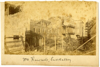
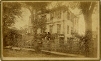
Charleston Earthquake scene. Possibly from Cook's Earthquake Views, no.63. William Ravenel, East Battery, rear. Written on front, at bottom: 'Wm Ravenel's, East Battery.'
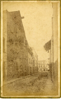
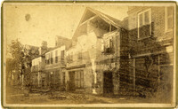
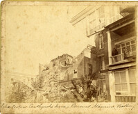
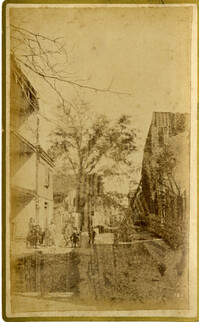
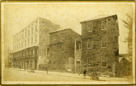
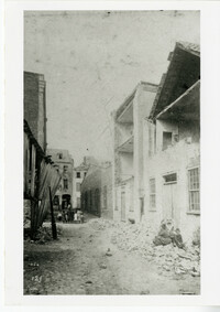
Caption: 'Cook's Earthquake Views of Charleston and Vicinity. Series No.2. No.181, Beresford Street.' This may be Beresford Alley which is also known as Clifford Street.
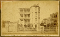
Caption: 'Cook's Earthquake Views of Charleston and Vicinity. Taken after the 31st of August, 1886. No.65, _____ Holmes, East Battery.' Written on front, at bottom: 'Charleston Earthquake scene - Holmes residence, East Battery.' Charleston city directory for 1886 shows Charles R. Holmes, Jr., at 19 East Battery.
Caption: 'Cook's Earthquake Views of Charleston and Vicinity. Series No.2. No.170, Buist residence, Rutledge Street.' Written on front, at bottom: Buist Residence, 43 Rutledge St.' Charleston city directory for 1886 shows listing for Samuel S. Buist at 43 Rutledge Avenue.
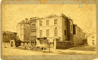
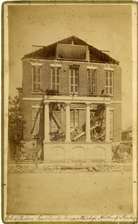
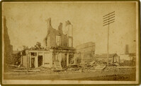
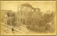
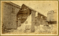
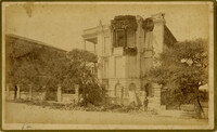
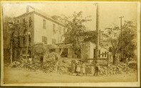
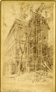
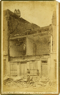
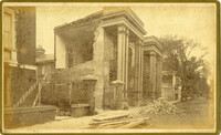
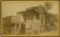
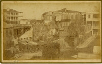
Caption: 'Cook's Earthquake Views of Charleston and Vicinity. Taken after the 31st of August, 1886. No.135, Corner State and Chalmers Streets.' Written on front, at bottom: 'Charleston Earthquake views - ruins cor[ner] Chalmers & State Str.'
Caption: 'Cook's Earthquake Views of Charleston and Vicinity. Series No.2. No.187, residence of Mr. A. Lengnick.' Charleston city directory for 1886 shows Albert Lengnick at 11 Pitt Street.
Caption: 'Cook's Earthquake Views of Charleston and Vicinity. Series No.2. No.167, rear of residence of Geo. [George] W. Williams, Jr.' Charleston city directory for 1886 shows George W. Williams, Jr. at 2 Atlantic Street.
Caption: 'Cook's Earthquake Views of Charleston and Vicinity. Series No.2. No.182, Porch of Lazarus House.' Hassell Street. Charleston city directory for 1886 shows Mrs. B.D. Lazarus at 64 Hassell Street.
Caption: 'Cook's Earthquake Views of Charleston and Vicinity. Taken after the 31st of August, 1886. No.60, J.M. Wilson, Meeting St.' Charleston city directory for 1886 shows James M. Wilson at 39 Meeting Street.
Caption: 'Cook's Earthquake Views of Charleston and Vicinity. Taken after the 31st of August, 1886. No.70, E.B. Hume, Legare Street.' Charleston city directory for 1886 shows Errington B. Hume at 17 Legare Street.
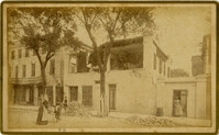
Caption: 'Cook's Earthquake Views of Charleston and Vicinity. Taken after the 31st of August, 1886. No.59, Pringle Smith, Meeting Street.' Written on front, at bottom: 'Earthquake scene Charleston, So.Ca.'
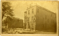
Caption: 'Cook's Earthquake Views of Charleston and Vicinity. Taken after the 31st of August, 1886. No.114, residence Col. Inglesby.' Charleston city directory for 1886 shows Charles Inglesby at 20 Meeting Street.
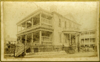
Caption: 'Cook's Earthquake Views of Charleston and Vicinity. Taken after the 31st of August, 1886. No.62, Wm. [William] Ravenel, East Battery, front.' Written on front, at bottom: 'Earthquake scene, Charleston, So.Ca. - Ravenel House'
Caption: 'Cook's Earthquake Views of Charleston and Vicinity. Taken after the 31st of August, 1886. No.134, Dr. Frazer's, Tradd Street.' Charleston city directory for 1886 shows listing for Dr. Henry D. Fraser at 139 Tradd, with offices at 137 Tradd.
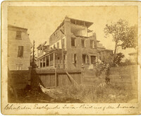
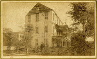
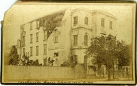
Caption: 'Charleston Earthquake. Photographs by Dr. E.P. Howland, taken on his visit to Charleston and the earthquake region of Ten Mile Hill and Summervile. Over 150 Photographs were taken. House of Mr. Ravenell [sic], President Northeastern R.R.'
Caption: 'Cook's Earthquake Views of Charleston and Vicinity. Taken after the 31st of August, 1886. No.78, Residence Wm. Johnson, Wentworth Street.' Charleston city directory for 1886 shows a William Johnson at 107 Wentworth Street.
Charleston Earthquake scene. Sign at bottom of image: 'Mr. August Melm's room, 21 King Street.' Also, written on front, at bottom: 'Earthquake - Charleston S.C. 1886.' Charleston city directory for 1886 lists August Melm, a local attorney, as boarding at 21 King Street.
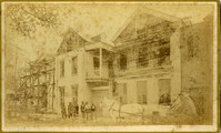
Caption: 'Cook's Earthquake Views of Charleston and Vicinity. Taken after the 31st of August, 1886. No.91, Brawley House, Legare Street.' Charleston city directory for 1886 shows Wm. H. Brawley at 9 Legare Street.
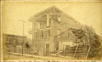
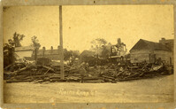
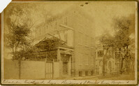
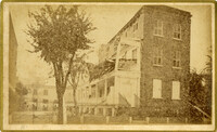
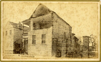
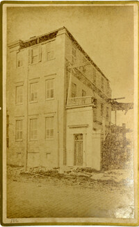
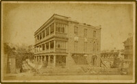
Charleston Earthquake scene. Written on front, at bottom: 'Sailor's Home, Charleston, S.C. after the Earthquake.' Sign at top of building reads: 'Charleston Port Society.'
Caption: 'Cook's Earthquake Views of Charleston and Vicinity. Taken after the 31st of August, 1886. No.66, _____ Alston, East Battery.' Charleston city directory for 1886 shows various members of the Alston family at 21 East Battery.
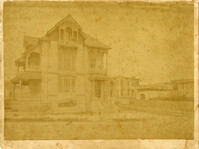
Caption: 'Charleston Earthquake. Photographs by Dr. E.P. Howland, taken on his visit to Charleston and the earthquake region of Ten Mile Hill and Summervile. Over 150 Photographs were taken. House of Mrs. Snowden, President of Confederate Home.'
Caption: 'Cook's Earthquake Views of Charleston and Vicinity. Taken after the 31st of August, 1886. No.61, Mrs. B.D. Lazarus, Hasel [sic] St.' Charleston city directory for 1886 shows Mrs. B.D. Lazarus at 64 Hassell Street.
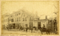
Caption: 'Cook's Earthquake Views of Charleston and Vicinity. Taken after the 31st of August, 1886. No.136, Meeting Street, cor. [of] Market.' Henry Steitz Produce is pictured. Charleston City directory for 1886 lists Henry Steitz, Fruits & Produce, at 113-115 Market Street.
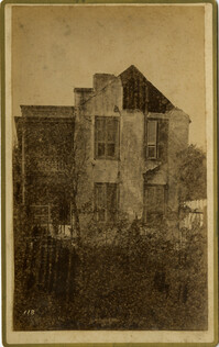
Caption: 'Cook's Earthquake Views of Charleston and Vicinity. Taken after the 31st of August, 1886. No.115, Corner [of] Market and Anson Streets.' Sign on building reads: 'Ship & Family Groceries.' Written on front, at bottom: 'Charleston Earthquake view - cor. Market and Anson sts.'
Charleston Earthquake scene. Written on reverse: 'East Battery, just below Atlantic Street. Edmonston [sic] House, later the Charles Alston residence. Now (1947) the residence of J.J. Pringle Smith. Old Holmes house on left. Earthquake of 1886 - Charleston, S.C.'
Caption: 'Cook's Earthquake Views of Charleston and Vicinity. Taken after the 31st of August, 1886. No. 55, Major R.C. Gilchrist, Bee St[reet].' Charleston city directory for 1886 shows Robert C. Gilchrist at 12 Bee Street.
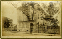
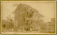
Caption: 'Cook's Earthquake Views of Charleston and Vicinity. Taken after the 31st of August, 1886. No.40, Bishop's house, Broad Street.' Handwritten at bottom, front: 'Charleston Earthquake scene - Bishop Northrup's Residence.' Charleston city directory for 1886 shows Bishop Henry P. Northrop at 114 Broad Street.
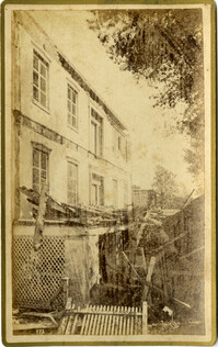
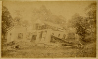
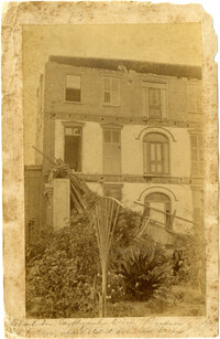
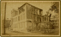
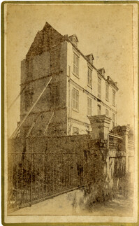
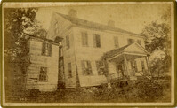
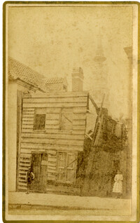
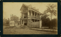
Charleston Earthquake scene, residence on Ashley Street. Handwritten on reverse: 'The residence of the Mayor of Charleston shattered by the Earthquake, Aug[us]t 31st 1886 and occupied by the Mayor's family unitl May 1887. Courtnay's [sic] residence. E.V.V. made bust of this man.'
Caption: 'Cook's Earthquake Views of Charleston and Vicinity. Taken after the 31st of August, 1886. No.67, G.W. Williams, Jr., Atlantic Street.' Charleston city directory for 1886 shows George W. Williams, Jr. at 2 Atlantic Street.
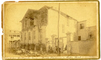
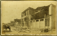
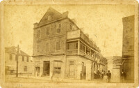
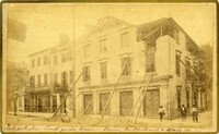
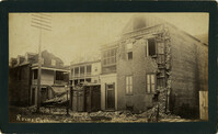
Caption: 'Cook's Earthquake Views of Charleston and Vicinity. Taken after the 31st of August, 1886. No.24, Market Street, north side.' Charleston Port Society building is pictured. Written on front, at bottom: 'View on Market St. at Charleston, S.C. after the Earthquake.'
Caption: 'Cook's Earthquake Views of Charleston and Vicinity. Taken after the 31st of August, 1886. No.131, residence J.N. Robson, south side.' Charleston city directory for 1886 shows James N. Robson at 200 Coming Street.
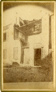
Charleston Earthquake scene. Possibly from Cook's Earthquake Views. No.68, John Kenney, Tradd Street. Charleston city directory for 1886 shows listing for John B. Kenney at 142 Tradd.
Charleston Earthquake Scene. Possibly from Cook's Earthquake Views, No.56, Alderman Murray's residence, Wentworth Street.' Charleston city directory for 1886 shows Andrew B. Murray at 175 Wentworth.
Caption: 'Cook's Earthquake Views of Charleston and Vicinity. Taken after the 31st of August, 1886. No.93, No.11 King Street.' Written on front, at bottom: 'Charleston Earthquake scene - Private residence on King St. near South Battery.'
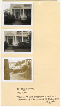
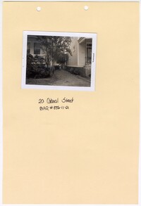
Three black and white photographs of No. 20 Colonial Street: Top (front facade/east elevation); Middle (front facade/east elevation); Bottom (front yard and sidewalk in front of structure). The photographs are stapled to a beige sheet of paper with two holes punched through the top. The paper is labeled "20 Colonial Street." There is a handwritten note on the paper explaining the purpose of the photographs. Their goal was to repair the porches at No. 20 Colonial Street. The note is signed by a "Smith." There is a white border surrounding all three photographs. The structure at No. 20 Colonial Street has a covered porch spanning the entirety of the exterior of the first story front facade/east elevation. There is a pediment held above the entryway of the porch by two Doric free standing columns. The first story is elevated with stairs leading up to the porch. There is a front yard covered in grass and an urban garden bordering the structure. There is a paved walkway to the entry stairs and a sidewalk running parallel to the street in front of the structure.
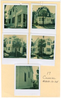
Five colored photographs of No. 17 Colonial Street and neighboring structures: Top left (north elevation of No. 17 Colonial Street); Top right (front facade/west elevation of the neighboring structure at No. 19 Colonial Street); Middle left (front facade/west elevation of the neighboring structure at No. 15 Colonial Street); Middle right (front facade/west elevation of No. 17 Colonial Street); Bottom (south elevation of No. 17 Colonial Street). The photographs are taped to a beige sheet of paper with two holes punched through the top. The paper is labeled "17 Colonial #808-13-35." There is a white border surrounding all five photographs. The structure at No. 17 Colonial Street is a two-and-a-half story structure with white horizontal exterior paneling. The neighboring structure at No. 15 Colonial Street is also a two-and-a-half story structure with white horizontal exterior paneling. Where the front facade is flat on No. 17 Colonial Street, there is a bay window at No. 15 Colonial Street. The neighboring structure at No. 19 Colonial Street is a three story Shingle style structure with a gambrel roof and dormer windows. The exterior siding consists of blue shingles on the third and second stories. The first story has white horizontal exterior paneling and a covered porch spanning the entire first story exterior.
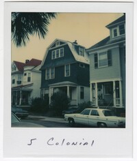
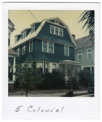
Colored photograph of the structure at No. 5 Colonial Street. The photograph has a white border with the label "5 Colonial" handwritten on the bottom half of the white border. The photograph was taken from across the street. Vehicles are visible parked on both sides of the street. The structure at No. 5 Colonial Street is a three-story Shingle style structure with a gambrel roof and dormer windows. The exterior siding consists of blue shingles on the third and second stories. The first story has white exterior paneling. There is a bay window on the left of the front facade/west elevation and a covered porch to the right. There is foliage obstructing the view of the first story. The neighboring structures to each side of No. 5 Colonial are visible in the photograph.
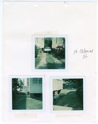
Three colored photographs of No. 10 Colonial Street: Top (parked vehicle in driveway); Bottom left (corner of west elevation and driveway); Bottom right (corner of south elevation and back yard). The three photographs are taped to a beige sheet of paper with two holes in the top. The paper is labeled as " 10 Colonial St." There is a white border surrounding all three photographs. The top photograph shows the north elevation of No. 10 Colonial Street and the south elevation of neighboring structure. The driveway is paved under where the tires of the vehicle sit. The center and sides of the driveway consist of grass. The bottom left photograph shows the back corner of the structure with a projecting bay window on the north elevation. The yard is covered in grass and lined with foliage along the border of the property in both of the bottom photographs.
Black and white photograph of No. 20 Colonial Street. The photograph is stapled to a beige sheet of paper with two holes punched through the top. The paper is labeled "20 Colonial Street BAR #835-11-21." There is a white border surrounding the photograph. The photograph shows a gravel path in between No. 20 Colonial Street and the neighboring structure to the right. The corner of the front facade/east elevation of No. 20 Colonial Street is visible as well as the corner of the front facade/east elevation and south elevation of the neighboring structure. There is foliage obstructing the view of the exterior of the first floor of No. 20 Colonial Street.
Colored photograph of the structure at No. 5 Colonial Street. The photograph has a white border with the label "5 Colonial" handwritten on the bottom half of the white border. The structure at No. 5 Colonial Street is a three-story Shingle style structure with a gambrel roof and dormer windows. The exterior siding consists of blue shingles on the third and second stories. The first story has white horizontal exterior paneling. There is a bay window on the left of the front facade/west elevation and a covered porch to the right. There is foliage obstructing the view of the first story. The neighboring structures to each side of No. 5 Colonial are visible in the photograph.
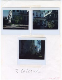
Three colored photographs of No. 3 Colonial Street: Top left (corner of front façade/west elevation and north elevation); Top right (front façade/west elevation and the southeastern corner of No. 5 Colonial Street); Bottom (side elevation). The photographs are taped to a white sheet of paper. The paper is labeled "3 Colonial" and "10-24-79." The exterior consists of white horizontal paneling. There is a bay window on the second story of the northeastern corner of the structure. Below the window on the first story is a covered porch with four free standing columns. Stairs lead onto the porch of the elevated first story. The front yard is covered in grass and shrubs. A sidewalk runs through the edge of the front yard. The neighboring structure located at No. 5 Colonial Street is visible in the top right photograph.
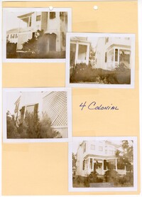
Four black and white photographs of No. 4 Colonial Street: Top left (side elevation); Top right (corner of front façade/east elevation and south elevation and neighboring structure); Bottom left (side elevation); Bottom right (corner of front façade/east elevation and south elevation). Each photograph is surrounded by a white border. The photographs are taped to a beige sheet of paper with two holes punched through the top. The paper is labeled as "4 Colonial." The two story structure has a porch spanning the majority of the exterior of the first story on the front facade/east elevation. The structure is slightly elevated with stairs leading up onto the first story front porch. There is foliage bordering the exterior of the structure on all sides.
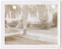
Black and white photograph of No. 4 Colonial Street. There is a white border surrounding the photograph with two holes punched through the top. The photograph shows the corner of the east elevation and the north elevation of the structure, as well as the neighboring structure to the left. The structure is elevated from the ground with a porch on the first story. The front yard is covered with grass and an urban garden bordering the structure. The sidewalk cuts through the edge of the front yard. There is a palm tree obstructing the view of the structure. There is a car parking in the bottom left corner of the photograph.
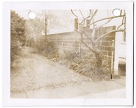
Black and white photograph of a wall located at No. 4 Colonial Street. There is a white border surrounding the photograph with two holes punched through the top. The photograph shows the retaining wall facing the north elevation of the structure at No. 4 Colonial Street. The wall separates No. 4 Colonial Street and No. 2 1/2 Colonial Street. The window of No. 2 1/2 Colonial Street can be seen behind the retaining wall in the photograph. There is grass covering the side yard with plants and trees planted along the retaining wall. A sidewalk is visible in the bottom of the photograph.


![[Elliott Street]](https://rspace.library.cofc.edu/iiif/image/50708/full/200,/0/default.jpg)