John writes that Union forces are putting torpedoes in the Stono river to blow up Confederate boats, but that all attempts, thus far, have been unsuccessful.
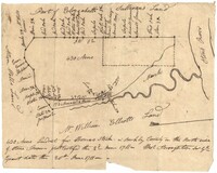
430 acres laid out for Thomas Stock in Berkeley County on the north side of Stono River. Names associated with this plat are William Elliott, Elizabeth Sullivan, Allen Wells, Thomas Stock and Thomas Broughton.
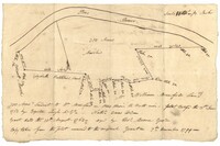
Sipros Openen Plantation, 342 acre plantation in Colleton county near Stono River, an island plantation, shows property lines and no land detail, also shows surrounding area outside of the plantation. Names associated with this plat are William Willersby, Alens [?], Thomas Lattson, Robert Murens, Ambers Helle, Charles Craven, Hells and Thomas Broughton. Notable geographic locations include Colleton County, Stono River, Sipros Opener, and Johns Island.
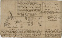
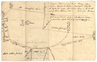
600 acres plot granted to Richard Floyd residing in Colleton County lying and budding on the southside of Bohickett Creek, shows surrounding property names and creeks, shows land notes but no land type or details. Also shown is 200 acres granted by the Lords Proprietors by William Arnell in Colleton County. Names associated with this plat are Richard Floyd, Graeme [?], the Lords Proprietors, Michael Ranell, Thomas Broughton, Robert Gibbes, William Atnel, Timothy Bellemey, Anthony Matthews, Ambross Hill, John Prescot and Neufville. Notable geographic locations include John's Island, Bohickett Creek, Colleton County, Ambrose Hill, Stono River, and Keywa [Kiawah] Island.
Plat of 300 acres in St. Andrew’s Parish on the Stono River originally granted to William Branford. At the time of the copy it belonged to George Wagner. Names associated with this plat are William Branford, George Wagner, Egerton Leigh, Thomas Boone and Elizabeth Hutchins.
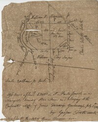
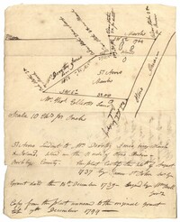
196 acres of land located in St Pauls Parish on a navigable branch of Stono River amd belonging to the confiscated estate of James D. Yarborough. Names associated with this plat include Thomas Ferguson, James Yarborough, G. Trotti, William Williamson, Charles Elliot, William Clay Snipes, Thomas Broughton, Edmond Bellinger, and Thomas Cliffon. Notable geographic locations include St. Paul's Parish, the Stono River, Road to Willows, Rutledge’s Creek, Road to Pon Pon and Jacksonborough.
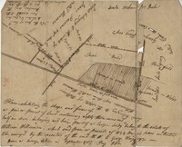
83 acre parcel of land that shows the land belonging to the estate of William Williamson, shows rice fields, swamp in woods, public drains, and roads. Names associated with this plat are William Williamson, George Haigery, and James Parsons. Notable geographic locations include the Stono River and Wenners.
Plat of 57 acres belonging to Dorothy Jones on the Stono River. At the time of the copy belonged to George Wagner. Names associated with this plat are Dorothy Jones, George Wagner, Bull and John St. James.
Plat of land annexed to a release from Benjamin Elliott to William Brandford for 362.5 acres. At the time of the copy belonged to George Wagner. Names associated with this plat include William Branford, Benjamin Elliott, Wagner George and Thomas Elliott.
The Mouzon Plat Book surveys lands held by various individuals and families in Craven County [now in parts of Berkeley, Charleston, Georgetown, and Williamsburg counties], Colleton County and Berkeley County in South Carolina. Plats are drawn in pencil and ink. Book includes an index at the beginning and at the end are two pages of accounts and also lands to be resurveyed for the estate of Henry Mouzon Jr.