Search
« Previous |
401 - 500 of 5,490
|
Next »
Search Results
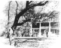
Date:
c.1950
Description:
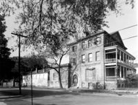
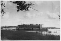
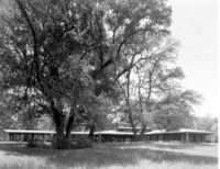
Printing on bottom states, "Qtrs "A"."
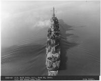
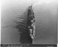
Date:
1943-06-21
Description:
Printing on bottom states, "1032-43 US Navy Yard, SC, June 21, 1943. DD 589 Stern, Down View. File 15617."
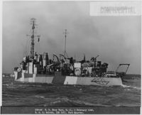
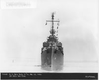
Date:
1945-02-01
Description:
Printing on bottom states, "293-45 US Navy Yard, SC, 1 February 1945. USS Badger (DD126), Port Quarter."
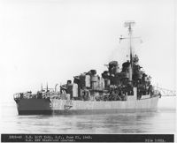
Date:
1943-06-21
Description:
Printing on bottom states, "1026-43 US Navy Yard, SC, June 21, 1943. DD 589 Starboard Quarter. File 15611."
Date:
1943-06-21
Description:
Printing on bottom states, "1028-43 US Navy Yard, SC, June 21, 1943. DD 589 Bow, Down View. File 15613."
Date:
1943-05-15
Description:
Printing on bottom states, "788-43 US Navy Yard, SC, May 15, 1943. (DD 588). Bow View. File 15440."
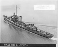
Date:
1944-04-27
Description:
Printing on bottom states, "953-44 US Navy Yard, SC April 27, 1944. USS Mayrant (DD 402), Port Quarter, Down View."
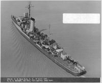
Date:
1944-04-20
Description:
Printing on bottom states, "864-44 US Navy Yard, SC April 20, 1944. USS Jonett (DD 396), Port Quarter, Down View."
Date:
1930
Description:
Under tab "New Construction". Printing on the bottom states, "1081"
Date:
1952-07-07
Description:
Printing on back states, "Work in connection with fire on Medregal (SS480)"
Date:
1952-07-07
Description:
Printing on back states, "Work in connection with fire on Medregal (SS480)"
Date:
1977-1983
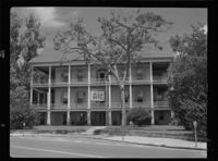
Description:
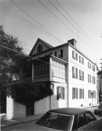
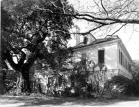
59 Meeting Street, Branford-Horry House, ca. 1751. View of SW (Rear and Side) elevation. 4" x 5" B/W photo.
Date:
1977-1983
Description:
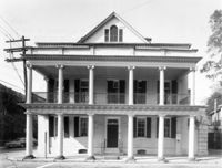
59 Meeting Street, Branford-Horry House, ca. 1751. View of East (Front) elevation. 4" x 5" B/W photo.
Date:
1880 and 1930
Description:
8 Meeting Street, Ladson House
Date:
1880 and 1930
Description:
East Bay and Amherst Streets
Date:
1880 and 1930
Description:
94 Rutledge Avenue
Date:
1880 and 1930
Description:
89 Beaufain Street
Date:
1886
Description:
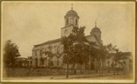
Caption: 'Cook's Earthquake Views of Charleston and Vicinity. Taken after the 31st of August, 1886. No.16, First Presbyterian Church.'
Date:
1886
Description:
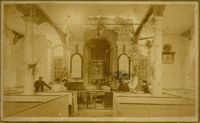
Caption: 'Cook's Earthquake Views of Charleston and Vicinity. Taken after the 31st of August, 1886. No.48, Goose Creek Church, interior.'
Date:
1886
Description:
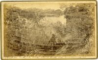
Caption: 'Cook's Earthquake Views of Charleston and Vicinity. Taken after the 31st of August, 1886. No.148, Landslide on the Ashley.' Handwritten at bottom, front: 'Charleston Earthquake view - Land slide near Summerville, S.C.'
Date:
1886
Description:
Charleston Earthquake scene. Possibly from Cook's Earthquake Views. Series No.2. No.169, College of Charleston, front [captioning missing, 'Cook No.169' handwritten on reverse].
Date:
1880 and 1930
Description:
1 East Battery
Date:
1880 and 1930
Description:
1 Meeting Street
Date:
1929-03-13
Description:
Image #159 (2.75" x 4.5"): "3-13-29. The closing bottom chord joint at L17! Member on left has slotted hole at pin."; Image #160 (2.75" x 4.5"): " Closing joint at L17! 4" slotted hole allows erection of closing chord at any temperature."; Image #161 (2.75" x 4.5"): "3-13-29 Progress."; Image #162 (2.75" x 4.5"): "3-3-29. Closing bottom chords in place.";Four 4.5" x 2.75" B/W photos numbered 159, 160, 161, 162
Date:
1977-1983
Description:
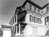
48 Elizabeth Street, Aiken-Rhett House, ca.1818. Complex - View of fence, West (Side) elevation. 4" x 5" B/W photo.
Date:
1977-1983
Description:
48 Elizabeth Street, Aiken-Rhett House, ca.1818. Complex - View of SW (Side and Front) elevation. 4" x 5" B/W photo.
Date:
1977-1983
Description:
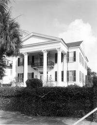
48 Elizabeth Street, Aiken-Rhett House, ca.1818. Main House - View of SE (Front and Side) elevation. 4" x 5" B/W photo.
Date:
1977-1983
Description:
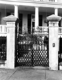
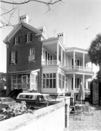
20 South Battery, Stevens-Lathers House, ca. 1843. Main House - Detail View of entry gate, South (Front) elevation. 4" x 5" B/W photo.
Date:
1977-1983
Description:
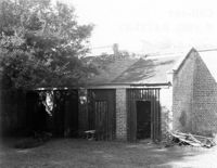
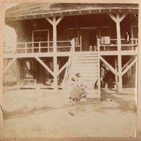
8 South Battery, Colonel William Washington House, ca. 1768. Stable - View of SE (Front) elevation. 4" x 5" B/W photo.
Date:
1977-1983
Description:
St. Margaret, West End, William Lowndes House, date unknown. View of East (Side) elevation. 4" x 5" B/W photo.
Date:
1977-1983
Description:
179 Rutledge Avenue, Wagener House, ca. 1874. Main House - View of West (Rear) elevation. 4" x 5" B/W photo.
Date:
1977-1983
Description:
172 Tradd Street, Chisolm-Alston House, ca. 1836. View of SE (Front and Side) elevation. 4" x 5" B/W photo.
Date:
1886-1916
Description:
8.5 x 8.5 cm photographic print
Date:
1942
Description:
Black and white print of the Amphritrite, a floating hotel docked at the Sinclair dock in order to relieve the housing shortage in Beaufort during World War II, 1942; 16.5 x 11 cm.
Date:
1950-1959
Description:
Black and white negative of the exterior of the Sea Island Hotel, 1950 - 1959; 11.2 x 8 cm.
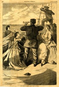
Date:
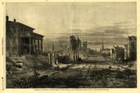
1864
Description:
Caption: 'Quarters of the Union officers exposed to the Federal fire in Charleston.--sketched by one of the Officers.--[see page 550.]' [full date August 27, 1864.]
Date:
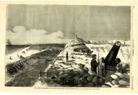
1863
Description:
Caption: 'The Siege of Charleston--the morning call to the Rebels.--sketched from the naval battery by Mr. Theodore R. Davis.--[see page 603.]' [full date September 19, 1863.]
Date:
1950-1959
Description:
Black and white negative of the driver training car provided to Beaufort High School by Horne Motor Company, 1950 - 1959; 11 x 8 cm.
Date:
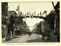
1887
Description:
Caption: 'Charleston--Celebration of her recovery from the effects of the Earthquake.--from a photograph by Cook.--[see page 818.]' [full date November 12, 1887.]
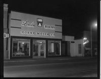
Date:
1950-1959
Description:
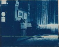
Black and white negative of the exterior of Horne Motor Company at night, 1950 - 1959; 13 x 10 cm.
Date:
1861
Description:
Caption: 'The principal church in Charleston, South Carolina.--see page 147.' [full date Feb. 16, 1861.]
Date:
1863
Description:
Caption: 'The approach of the British pirate "Alabama."' [full date April 25, 1863.]
Date:
1977-1983
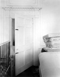
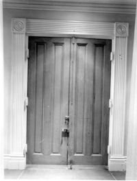
Description:
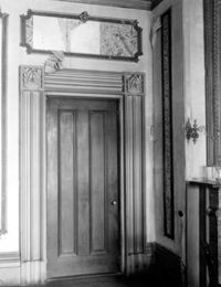
286 Calhoun Street, Jonathan Lucas House, ca. 1809. Main House - Interior View. 1st Floor - SE Room, Detail of door to hallway, West elevation. 4" x 5" B/W photo.
Date:
1977-1983
Description:
172 Rutledge Avenue, Ashley Hall, ca. 1802. Main House - Interior View. 1st Floor - SE Room, NE corner. 4" x 5" B/W photo.
Date:
1955
Description:
Black and white negative of a man trying on hats for sale in the Edward's dime store taken on Nov. 17th, 1955; 13.5 x 10 cm.
Date:
1955
Description:
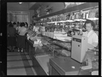
Black and white negative of the confectionary counter in the Edward's dime store taken on Nov. 17th, 1955; 13.5 x 10 cm.
Date:
1954
Description:
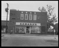
Black and white negative of the exterior of the Edward's store entrance from Port Republic Street, 1954; 12.5 x 10 cm.
Date:
1860
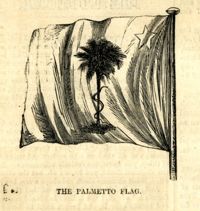
Description:
Caption: 'The Palmetto flag.' [full date November 24, 1860.]
Date:
1865
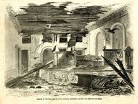
Description:
Caption: 'Interior of the State Bank of South Carolina, Charleston, showing the effect of our shells.' [full date April 1, 1865.]
Date:
circa 1863
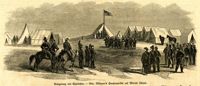
Description:
Caption in German: 'Belagerung von Charleston.--Gen. Gillmore's hauptquartier auf Morris Island.' [Siege of Charleston.--Gen. Gillmore's headquarters on Morris Island.]
Date:
1863
Description:
Caption: 'The siege of Charleston--View from the sea-face of Fort Wagner.--sketched by Mr. Theodore R. Davis.--[See Page 621.]' [full date September 26, 1863.]
Date:
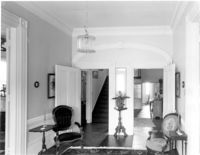
1977-1983
Description:
Charleston County, Oak Island Plantation, ca. 1830. Interior View. 1st Floor - South Entry Hall, looking North. 4" x 5" B/W photo.
Date:
1977-1983
Description:
Charleston County, Oak Island Plantation, ca. 1830. Interior View. 1st Floor - SW Room, North wall. 4" x 5" B/W photo.
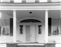
Date:
1977-1983
Description:
Charleston County, Oak Island Plantation, ca. 1830. Detail View of portico entry, South (Front) elevation. 4" x 5" B/W photo.
Date:
1977-1983
Description:
105 Meeting Street, Hibernian Society Hall, ca. 1840. Interior View. Ground Floor - Rotunda, Detail of entry doors, West elevation. 4" x 5" B/W photo.
Date:
1977-1983
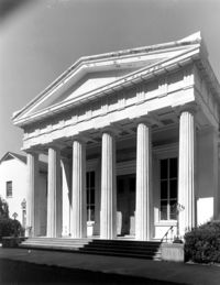
Description:
90 Hasell Street, Synagogue of Kahal Kadosh Beth Elohim, ca. 1840. View of West (Front) elevation. 4" x 5" B/W photo.
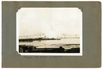
Date:
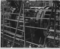
1929-02-15
Description:
Unnumbered Image (5" x7"): "Progress, Feb. 15, 1929 at 4:30 P.M.";One 5" x 7" B/W photo
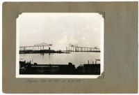
Date:
1929-02-22
Description:
Unnumbered Image (5" x 7"): "Progress Feb. 22, 1929 at 4:30 P.M.";One 5" x 7" B/W photo
Date:
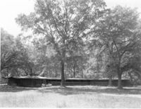
1977-1983
Description:
Beaufort County, Auldbrass Plantation, ca. 1951. Tack Room and Stables (From Left to Right) - View of East elevation. 4" x 5" B/W photo.
Date:
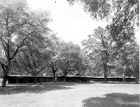
1977-1983
Description:
Beaufort County, Auldbrass Plantation, ca. 1951. Kennels and Stable (From Left to Right) - View of East elevation. 4" x 5" B/W photo.
Date:
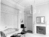
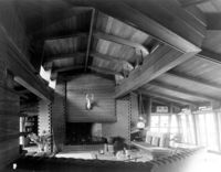
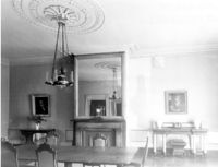
1977-1983
Description:
Beaufort County, Auldbrass Plantation, ca. 1951. Main House - Interior View. Living Room, looking South. 4" x 5" B/W photo.
Date:
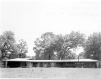
1977-1983
Description:
Beaufort County, Auldbrass Plantation, ca. 1951.Main House - View of East elevation. 4" x 5" B/W photo.
Date:
1977-1983
Description:
Beaufort County, Auldbrass Plantation, ca. 1951. Main House - View of NE elevation. 4" x 5" B/W photo.
Date:
1889-1895
Description:
9.8 x 12.2 cm photographic print
Date:
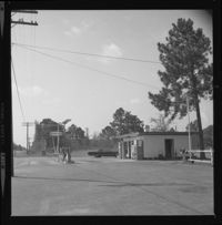
1969
Description:
Black and white negative of the exterior of the Interstate gas station, owned by Mr. Heyward, 1969; 6 x 6 cm.
Date:
1977-1983
Description:
48 Elizabeth Street, Aiken-Rhett House, ca.1818. Main House - Interior View. 2nd Floor - Hall, looking North towards Stair Hall. 4" x 5" B/W photo.
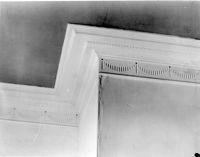
Date:
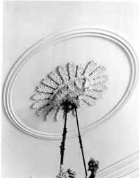
1977-1983
Description:
48 Elizabeth Street, Aiken-Rhett House, ca.1818. Main House - Interior View. 2nd Floor - Hall. Detail of ceiling medallion. 4" x 5" B/W photo.
Date:
1889-1895
Description:
9.2 x 12.1 cm photographic print
Date:
1886-1916
Description:
12.4 x 10.0 cm photographic print
Date:
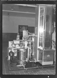
1950-1959
Description:
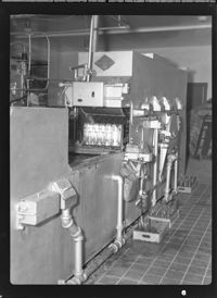
Black and white negative of the interior of the Coca-Cola bottling factory, 1950 - 1959; 8 x 11 cm.
Date:
1950-1959
Description:
Black and white negative of the interior of the Coca-Cola bottling factory, 1950 - 1959; 11 x 8 cm.
Date:
1950-1959
Description:
Black and white negative of the interior of the Coca-Cola bottling factory, 1950 - 1959; 11 x 8 cm.
Date:
1977-1983
Description:
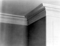
Berkley County, Mulberry Plantation, ca. 1714. Main House - Interior View. 1st Floor - SW Room. Detail of cornice, North wall. 4" x 5" B/W photo.
Date:
1886-1916
Description:
6.8 x 6.6 cm photographic print
Date:
1960-1969
Description:
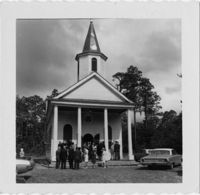
Black and white print of the exterior of the Stoney Creek Presbyterian Church with people in churchyard, 1990; 7.5 x 7.5 cm.
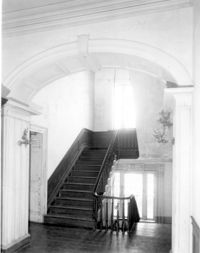
Date:
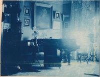
1977-1983
Description:
64 South Battery, William Gibbes House, ca. 1772. Main House - Interior. 1st Floor - Hall (from the front entry), North elevation. 4" x 5" B/W photo.
Date:
1977-1983
Description:
64 South Battery, William Gibbes House, ca. 1772. Main House - Interior. 1st Floor - Hall. Detail of door cornice and frieze. 4" x 5" B/W photo.
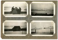
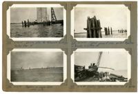
Date:
1929-04-26 and 1929-04-24
Description:
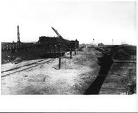
Image #264 (2.75" x 4.5"): "4-24-29. Driving piles for falsework footings. Anchor Pier 10."; Image #266 (2.75" x 4.5"): "Progress in Cooper River. Looking north."; Image #265 (2.75" x 4.5"): "4-24-29. Typical group of piles pulled together for bracing & cutting off."; Image #267 (2.75" x 4.5"): "4-26-29. Loading cypress piles from car to lighter.";Four 4.5" x 2.75" B/W photos numbered 264, 265, 266, 267
Date:
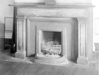
1977-1983
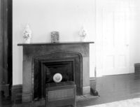
Description:
48 Elizabeth Street, Aiken-Rhett House, ca.1818. Main House - Interior View. 1st Floor - East Room. Detail of mantle. 4" x 5" B/W photo.
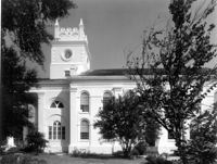
Date:
1977-1983
Description:
126 Coming Street, Cathedral Church of St. Luke and St. Paul, ca. 1816. View of South (Side) elevation. 4" x 5" B/W photo.
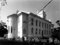
Date:
1977-1983
Description:
126 Coming Street, Cathedral Church of St. Luke and St. Paul, ca. 1816. View of North (Side) elevation. 4" x 5" B/W photo.
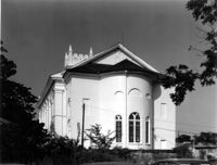
Date:
1977-1983
Description:
126 Coming Street, Cathedral Church of St. Luke and St. Paul, ca. 1816. View of East (Rear) elevation. 4" x 5" B/W photo.
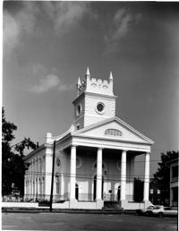
Date:
1977-1983
Description:
126 Coming Street, Cathedral Church of St. Luke and St. Paul, ca. 1816. View of West (Front) elevation. 4" x 5" B/W photo.
Date:
1977-1983
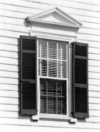
Description:
8 South Battery, Colonel William Washington House, ca. 1768. Main House - Detail View of 1st Floor window. 4" x 5" B/W photo.
Date:
1865
Description:
[Color image.] Caption: 'Feeding 8,000 people with rations of rice and salt at West Point Mills, on the Ashley River, Charleston S.C.-- From a sketch by our Special Artist, W.T. Crane.' [full date April 15, 1865.]
Date:
1885
Description:
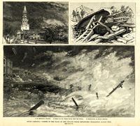
Main caption: 'South Carolina.--scenes in the track of the cyclone which devastated Charleston, August 25th. See page 43. 1. St. Michael's Church [upper left]. 2. Scene on the water front after the storm [top right]. 3. Destruction on South Battery [bottom].' [full date September 5, 1885.]
Date:
1977-1983
Description:
48 Elizabeth Street, Aiken-Rhett House, ca.1818. Main House - Interior View. 1st Floor - SW Room. Detail of mantle. 4" x 5" B/W photo.
Date:
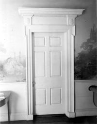
1977-1983
Description:
48 Elizabeth Street, Aiken-Rhett House, ca.1818. Main House - Interior View. 1st Floor - Detail of door and case 4" x 5" B/W photo.
Date:
1977-1983
Description:
48 Elizabeth Street, Aiken-Rhett House, ca.1818. Main House - Interior View. 1st Floor - East Room, East wall. 4" x 5" B/W photo.
Date:
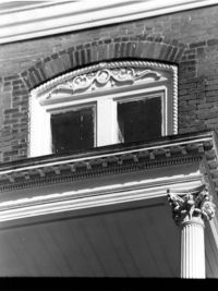
1977-1983
Description:
16 Meeting Street, Calhoun Mansion, ca. 1876. Detail View of entry portico cornice and 3rd Floor center window, West (Front) elevation. 4" x 5" B/W photo.
Date:
1977-1983
Description:
Charleston County, Cassina Point Plantation, ca. 1847. Interior View. 1st Floor - SW Room, Looking to NE corner of SE Room. 4" x 5" B/W photo.
Date:
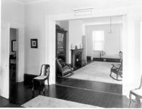
1977-1983
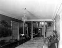
Description:
Charleston County, Cassina Point Plantation, ca. 1847. Interior View. 1st Floor - North Central Stair Hall, looking North. 4" x 5" B/W photo.
Date:
1977-1983
Description:
Charleston County, Cassina Point Plantation, ca. 1847. Interior View. 2nd Floor - Hall, looking South from landing. 4" x 5" B/W photo.
Date:
1892-1916
Description:
9.7 x 15.5 cm photographic print
Date:
1892-1916
Description:
10.2 x 15.5 cm photographic print
Date:
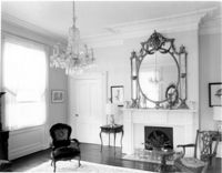
1977-1983
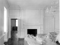
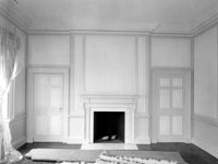
Description:
Berkley County, Loch Dhu, ca. 1812. Main House - Interior View. 1st Floor - SW Room, North wall. Detail of cornice. 4" x 5" B/W photo.
Date:
1977-1983
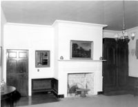
Description:
Berkley County, Loch Dhu, ca. 1812. Main House - Interior View. 1st Floor - SE Room, North wall. 4" x 5" B/W photo.
Date:
1977-1983
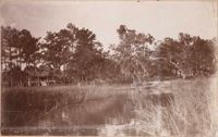
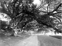
Description:
Berkley County, Mulberry Plantation, ca. 1714. Driveway - View of Live Oak trees. From West, looking East. 4" x 5" B/W photo.
Date:
1977-1983
Description:
6 Glebe Street, St. Philip's Parsonage House (Bishop Robert Smith House), ca. 1770. Interior View. 1st Floor - SW Room, North wall. 4" x 5" B/W photo.
Date:
1977-1983
Description:
6 Glebe Street, St. Philip's Parsonage House (Bishop Robert Smith House), ca. 1770. Interior View. 2nd Floor - SE Room, North wall. 4" x 5" B/W photo.