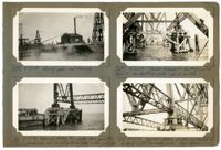
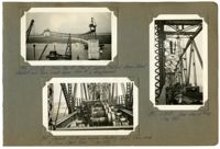
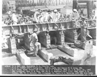
Image #258 (2.75" x 4.5"): "4-23-29. Driving piles and framing."; Image #260 (2.75" x 4.5"): "4-23-29. Falsework footing #16, under deck span #10. Two (2) plumb piles and six (6) battered piles under each col."; Image #259 (2.75" x 4.5"): "4-23-29. Timber falsework footings under Span 10. Av. depth of water = 25' at low tide."; Image #261 (2.75" x 4.5"): "4-24-29. typical detail of steel falsework col. on ton of 2-200 ton wedge jacks. Deck spans.";Four 4.5" x 2.75" B/W photos numbered 258, 259, 260, 261
Image #244 (2.75" x 4.5"): "4-18-29. Span 5 completed. Viaduct Traveler at left being removed by stiffleg derrick, which it has set up in front of it."; Image #245 (2.75" x 4.5"): "4-18-29. Spans 11 and 12 completed."; Image #246 (4.5" x 2.75"): "4-23-29. Erecting Span 10. Taken from near Pier 12, looking west toward Pier 11, anchor pier 10 and main piers 9 and 8.";Three 4.5" x 2.75" B/W photos numbered 244, 245, 246
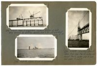
Image #284 (4.5" x 2.75"): "4-30-29. Same as 283."; Image #287 (2.75" x 4.5"): "5-1-29. Anchor bent completed on Pier 7."; Image #288 (2.75" x 4.5"): "5-2-29. Progress in Cooper River. Both travelers are standing over the anchor piers - ready to start erection of main span.";Three 4.5" x 2.75" B/W photos numbered 284, 287, 288
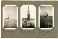
Image #248 (4.5" x 2.75"): "4-23-29. Span 5 completed and working on Span 6."; Image #249 (4.5" x 2.75"): "4-23-29. From top of anchor pier 7, looking west toward Span Traveler B erecting Span 6." Image #250 (4.5" x 2.75"): 4-23-29. From top of viaduct at bent #12E, looking west. Town Creek Span in distance.";Three 4.5" x 2.75" B/W photos numbered 248, 249, 250
Image #76 (2.75" x 4.5"): Temporary top chord links between U13 and U14, carrying diaphragms for hydraulic jacks - Town Creek Span."; Image #77 (2.75" x 4.5"): "End view of links shown in #76."; Image #78 (2.75" x 4.5): "End view of top chords U12 U13 at U13. (see #87).";Three 4.5" x 2.75" B/W photos numbered 76, 77, 78
Image #272 (2.75" x 4.5"): "4-28-29. Town Creek Span, looking east from near the end of west approach."; Image #273 (2.75" x 4.5"): "4-28-29. Progress in Cooper River."; Image #274 (2.75" x 4.5"): "4-29-29. Traveler A erecting end floorbeam of west anchor arm at Pier 10."; Image #275 (2.75" x 4.5"): "End floorbeam of west anchor arm hung on stringers of deck span. First steel erected on anchor arm.";Four 4.5" x 2.75" B/W photos numbered 272, 273, 274, 275
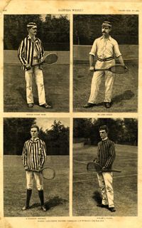
Main caption: 'Leading lawn-tennis players.--photographed by E.M. Bidwell.--[see page 583.]' Caption top left: 'Richard Dudley Sears.' Caption top right: 'Dr. James Dwight.' Caption bottom left: 'R. Livingston Beeckman.' Caption bottom right: 'Howard A. Taylor.' [full date September 11, 1886.]
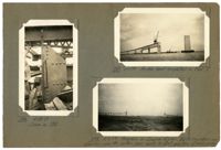
Image #194 (2.75" x 4.5"): "3-27-29. From top of Pier 6, looking toward Drum Island viaduct and Town Creek Span. Pier 5 in foreground."; Image #195 (2.75" x 4.5"): "Second 150 HO gas. Engine starting down thru deck of Town Creek Span. (See 188)"; Image #196 (4.5" x 2.75"): "3-28-29. rear view of #195. (See 188)";Three 4.5" x 2.75" B/W photos numbered 194, 195, 196
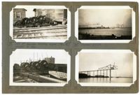
Image #79 (2.75" x 4.5"): "150 HP Gasoline hoisting engine (#5 or #6). Weight 31 tons."; Image #80 (2.75" x 4.5"): "100 HP Gasoline hoisting engine (#7). Weight about 26 tons."; Image #81 (2.75" x 4.5"): "Progress 2-1-29."; Image #82 (2.75" x 4.5"): "2-7-29. West cantilever completed to L12. Traveler at L10. Town Creek.";Four 4.5" x 2.75" B/W photos numbered 79, 80, 81, 82
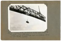
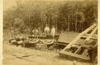
Unnumbered Image (5" x 7"): "Lowering 33 ton, 150 HP Gasoline hoisting engine, under its own power. Town Creek Span. Ridden down by W.E. Omohundro, Sup't., W.S. Patterson, Pusher, and John Shelton, Engineman.";One 5" x 7" B/W photo
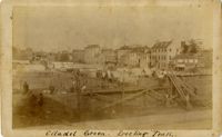
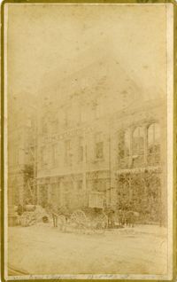
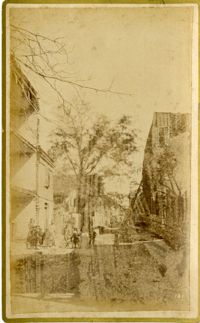
Caption: 'Cook's Earthquake Views of Charleston and Vicinity. Taken after the 31st of August, 1886. No.125, Scene near Atlantic Wharf.' Charleston city directory for 1886 lists Atlantic Wharf at the rear of the Post Office.
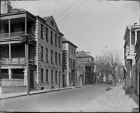
Caption: 'Cook's Earthquake Views of Charleston and Vicinity. Taken after the 31st of August, 1886. No.82, East Bay Street.' Sign for Jas [James] Ackermann at 114 East Bay is visible.
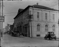
Caption: 'Cook's Earthquake Views of Charleston and Vicinity. Taken after the 31st of August, 1886. No.133, 5 and 7 Broad Street.' Written on front, at bottom: 'Walker, Evans & Cogswell, Broad St.' Charleston City Directory for 1886 shows Walker, Evans & Cogswell at 3-5 Broad Street. Etiwan[Phosphate] Company is at 7 Broad.
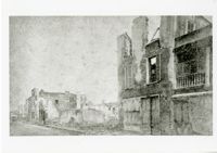
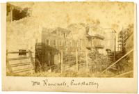
Charleston Earthquake scene. Possibly from Cook's Earthquake Views, no.63. William Ravenel, East Battery, rear. Written on front, at bottom: 'Wm Ravenel's, East Battery.'
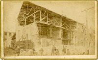
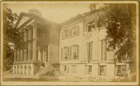
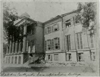
Caption: 'Cook's Earthquake Views of Charleston and Vicinity. Taken after the 31st of August, 1886. No.129, College as torn down.' Handwritten at bottom, front: 'Charleston Earthquake views - Charleston College. Both wings gone.'
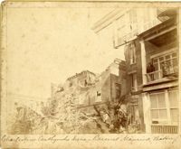
Caption: 'Cook's Earthquake Views of Charleston and Vicinity. Series No.2. No.181, Beresford Street.' This may be Beresford Alley which is also known as Clifford Street.
Caption: 'Cook's Earthquake Views of Charleston and Vicinity. Taken after the 31st of August, 1886.' Possibly No.178, but corresponding captioning is missing. Handwritten on reverse: 'Formerly St. Luke's Episcopal now [New Tabernacle] Fourth Baptist Church, 22 Elizabeth Street.' Handwritten at bottom, front: 'Charleston Earthquake scene - St. Luke's Episcopal Church.'
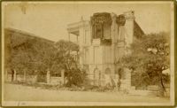
Caption: 'Cook's Earthquake Views of Charleston and Vicinity. Taken after the 31st of August, 1886. No.65, _____ Holmes, East Battery.' Written on front, at bottom: 'Charleston Earthquake scene - Holmes residence, East Battery.' Charleston city directory for 1886 shows Charles R. Holmes, Jr., at 19 East Battery.
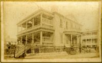
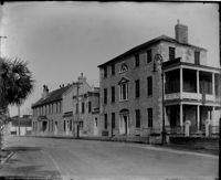
Caption: 'Cook's Earthquake Views of Charleston and Vicinity. Series No.2. No.170, Buist residence, Rutledge Street.' Written on front, at bottom: Buist Residence, 43 Rutledge St.' Charleston city directory for 1886 shows listing for Samuel S. Buist at 43 Rutledge Avenue.
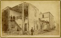
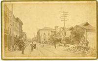
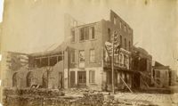
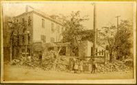
Caption: 'Cook's Earthquake Views of Charleston and Vicinity. Taken after the 31st of August, 1886. No.135, Corner State and Chalmers Streets.' Written on front, at bottom: 'Charleston Earthquake views - ruins cor[ner] Chalmers & State Str.'
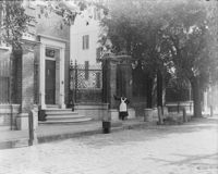
Caption: 'Cook's Earthquake Views of Charleston and Vicinity. Series No.2. No.187, residence of Mr. A. Lengnick.' Charleston city directory for 1886 shows Albert Lengnick at 11 Pitt Street.
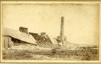
Caption: 'Cook's Earthquake Views of Charleston and Vicinity. Taken after the 31st of August, 1886. No.99, Rear of Scotch Church.' Handwritten at bottom, front: 'Charleston Earthquake scene - Rear of First Presbyterian Church.'
Caption: 'Cook's Earthquake Views of Charleston and Vicinity. Taken after the 31st of August, 1886. No.99, Rear of Scotch Church.' First (Scots) Presbyterian Church on Meeting Street.
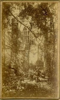
Caption: 'Cook's Earthquake Views of Charleston and Vicinity. Taken after the 31st of August, 1886. No.79, St. Mary's Church. [And handwritten] Hasell Street.'
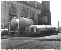
Under tab "Power Plant". Printing on bottom states, "586-39 US Navy Yard, Charleston, SC 17 October 1939. Improvement of Power Plant. Allotment 7-08/0679.1-91-1 (PWA). 5000 c.f.m. steam driven Air Compressor. Contract NOy-3216. Looking northeast. File 7880."
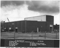
Printing on bottom states, "(1) Non-Classified (2) EST-629 (3) Charleston Naval Shipyard, Charleston, South Carolina (4) 25 May 1966 (5) Nuclear Service Building (6) Not Applicable (7) Exterior of Bldg & Compound (8) Looking East (9) NBy-608020 (10) NBy-EST."