This is the order book associated with the 4th South Carolina Regiment, which was established in November 1775 and formed part of the U.S. Continental Army between June 18, 1776 and January 1, 1781, when it was disbanded following the British capture of Charleston. It also contains orders relating to the 1st and 2nd South Carolina Regiments from September 15, 1775 onward, beginning with the capture of Fort Johnson. It discusses the allocation of men and material to various fortifications around the Charleston area, including Fort Sullivan, Fort Johnson, and the Grand Battery. The book accompanied Captain Barnard Elliott (d. 1778), who was reassigned from the 2nd to the 4th Regiment in November, 1775. Considerable reference is made to war plans, military discipline, including courts-martial, and camp life.
Letter from William Gill, James Johnson, William Greu, and Isaac A. [Kerlark?], the committee of the Temperance Society of 'F' Company, 2nd Regiment of Artillery, stationed at Fort Moultrie, to Thomas S. Grimke, President of the South Carolina Temperance Society regarding becoming an auxiliary organization.
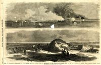
Caption: 'Siege of Charleston--1.Bombardment of Fort Moultrie and the Batteries Bee and Beauregard, by the monitors and ironsides, Sept. 7th and 8th.--2. Interior of Battery Gregg, looking towards Wagner. From sketches by our Special Artist, W.T. Crane.' [full date October 3, 1863.]
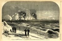
Caption: 'The Siege of Charleston--bombardment of Fort Moultrie by the iron-clads, September 8, 1863.--sketched by Mr. Theodore R. Davis.--[see page 621.] Also identified in the image: Moultrieville, Fort Moultrie and Moultrie House. [full date September 26, 1863.]
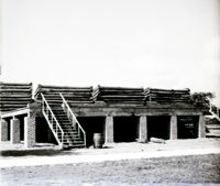
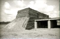
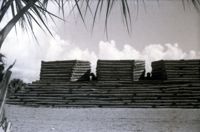
Bicentennial reconstruction of Fort Moultrie, exterior from a distance with brick fort and spire of Stella Maris Catholic Church in the background. Page 45, Image 13 of collection. Original is 35 mm B/W negative.
Letter from J.F. Heilman, President of the Charleston Temperance Society, to Thomas S. Grimke, President of the South Carolina Temperance Society, in reference to a newly formed Temperance Society of 'F' Company, 2nd Regiment of Artillery, stationed at Ft. Moultrie.
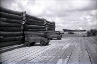
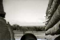
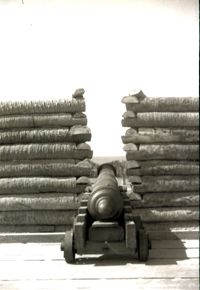
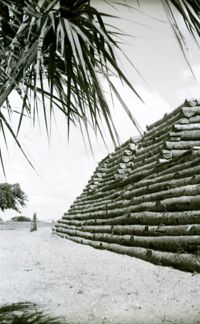
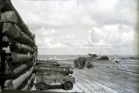
Bicentennial reconstruction of Fort Moultrie, interior with cannons and Seatrain Lines container ship visible in the background. Page 45, Image 9 of collection. Original is 35mm B/W negative.
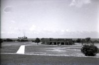
Bicentennial reconstruction of Fort Moultrie, interior, from a distance with a container ship visible in the background. Page 45, Image 10 of collection. Original is 35mm B/W negative.
Oil painting by Lt. William Elliott depicts the abortive attack on Fort Moultrie during the American Revolution. Plate on painting reads: "Charlestowne South Carolina. The abortive attack of Fort Moultrie 26th June, 1776, by a British naval force under Commodore Sir Peter Parker consisting of HMS's Bristol, Active, Experiment, Solebay, Actaeon, Syren, Sphinx, and bomb vessel Thunder. Lt. Wm. Elliott RN, Fl 1784-1792, Hon. Exhibitor at the Royal Academy."
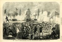
Caption: 'Bombardment of Fort Sumter, as sketched from Morris Island, Charleston Harbor, S.C.' Identified in image: Mortar Battery, Fort Johnson; James Island; City; Castle Pinckney; Fort Sumter; Mount Pleasant; Floating Battery; Mortar Battery; Fort Moultrie; Enfilading Battery; Iron Battery; Sand-bag cover for reserve; Traverse behind Trapier Battery and Magazine covered with sand bags.
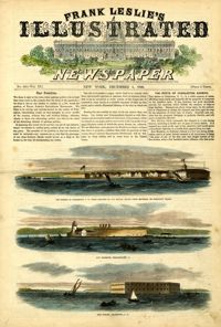
[Color image.] Caption at top: 'The harbor of Charleston, S.C.--From sketches by our special artist.--Fort Moultrie, on Sullivan's Island.' Caption at middle: 'Fort Pinckney, Charleston, S.C.' Caption at bottom: 'Fort Sumter, Charleston, S.C.' [full date Dec. 1, 1860.]
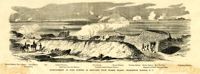
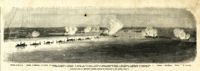
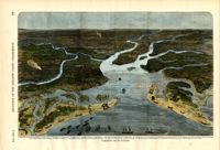
Caption: 'Panoramic view of Charleston Harbor--advance of iron-clads to the attack, April 7. Union--A. Keokuk. B. Nahunt. C. Nantucket. D. Catskill. E. Ironsides. F. Patapsco. G. Montauk. H. Passaie. K. Weehawken. Rebel--1. Morris Island sand battery. 2. Fort Wagner. 3. Battery Bee, on Cummings Point. 4. [Fort] Johnson. 5. Fort Ripley. 6. Sumter. 7. Charleston City. 8. Castle Pinckney. 9. Fort Redan. 10. Fort Moultrie. 11. Moultrie House. 12. Fort Beauregard. 13. Harbor obstructions. 14. Cooper River. 15. Ashley River.' [full date May 2, 1863.]
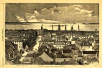
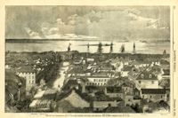
Caption: 'The city of Charleston, South Carolina.--[see page 62.]' Also identified in image: Broad Street, "Mercury" office, Custom-house, Castle Pinckney, Fort Moultrie, Fort Sumter and Morris Island. [full date January 26, 1861.]
Main caption: 'Siege of Charleston--views of Sullivan's Island, as seen from Morris Island.--from sketches by our Special Artist, W.T. Crane.' Caption top left: 'Remains of blockade runners.' Caption top right: 'Rebel camp on Sullivans Island.' Caption middle left and right: 'Rebel battery on Sullivans Island.' Caption middle: 'Examining passes on the beach.' Caption bottom: ' Fort Moultrie as seen from Morris Island.' [full date October 10, 1863.]
[Color image.] Caption (in French): 'Evenements des Etats-Unis: Charleston et ses fortifications. [Events of the United States: Charleston and its fortifications.] 1--Charleston. 2--Riviere Ashley [Ashley River]. 3--Chemin de fer de Savannah [Savannah Railway]. 4--Riviere Cooper [Cooper River]. 5--Riviere Wando [Wando River]. 6--Fort Pinkney [Castle Pinckney]. 7--Fort Ripley. 8--Fort Johnson (ile James) [James Island]. 9--Riviere Stone [Stono River]. 10--Fort Sumter. 11--Fort Moultrie. 12--Batterie Gregg (pointe de Gumming) [Battery Gregg (Cummings Point)]. 13--Fort Wagner. 14--Batteries rasantes du general Gilmore [grazed batteries of General Gilmore]. 15--Ouvrages pris par les federaux. [Works undertaken by the Federals]. 16--Phare Inlet [Lighthouse inlet]. 17--Batteries federales (ile Folly) [Federal Batteries (Folly Island)]. 18--Canonnieres et vaisseaux cuirasses [gunboats and ironclads]. 19--Hotel. 20--Ile et batteries Sullivan [Sullivan Island and Batteries]. 21--Moultrie. 22--Mont Pleasant [Mount Pleasant]. 23--Breach Inlet. 24--Shem Creek. 25--Batteries construite par les confederes sur l'ile James, dans le voisinage du fort Johnson [Batteries built by the Confederates on James Island, in the vicinity of Fort Johnson].
Caption: 'The city of Charleston, South Carolina, looking seaward, and showing the burned district.--[see next page.]' Identified in image are: Broad Street, "Mercury" office, Custom-house, Castle Pinckney, Fort Moultrie, Fort Sumter and Morris Island. [full date December 28, 1861.]
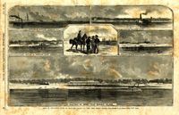
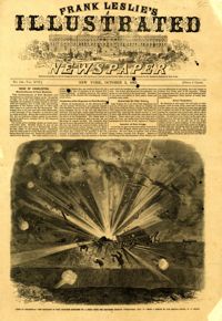
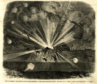
Caption: 'Siege of Charleston--the magazine of Fort Moultrie exploded by a shell from the grounded monitor Weehawken, Sept. 8.--from a sketch by our own Special Artist, W.T. Crane.' [full date October 3, 1863.]
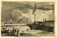
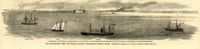
Caption: 'Our blockading fleet off North Channel, Charleston Harbor, South Carolina.--sketched by a Naval Officer.--[see page 79.] References--A. Fort Sumter.--B. Charleston City.--C. Fort Moultrie.--D. Rebel tug at work on the obstructions.--E. Obstructions.--F. Fort Johnson.--G. Mount Pleasant Batteries.' Also identified in image: South Carolina, Blunt, Daylight and Stars and Stripes (ships of the fleet). [full date January 31, 1863.]
Caption: 'Siege of Charleston--the magazine of Fort Moultrie exploded by a shell from the grounded monitor Weehawken, Sept. 8.--from a sketch by our own Special Artist, W.T. Crane.' [full date October 3, 1863.]
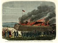
[Color image.] Caption (in French): 'Les troupes federales evacuant le fort Moultrie, apres avoir detruit le materiel de guerre.--D'apres les croquis de M.W.S. (Voir la Revuie de la semaine.)' [Federal troops evacuate Fort Moultrie, after destroying war materials.--from the sketch by M.W.S. (see the Review of the Week)].
A letter from Benjamin King (Ft. Moultrie, 1826) describes the wreck of the ship Harvest off the coast of North Carolina in which Lieutenant Benjamin Grimke and his infant daughter were drowned, but which his wife and King survived; with details on their shipwreck on Boddy's Island, wreckers salvaging the ship, burial of the dead and travel to Roanoke.
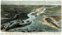
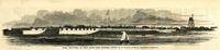
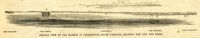
Caption: 'Profile view of the harbor of Charleston, South Carolina, showing the city and forts.' Identified in the image: Fort Johnston (sic), Fort Sumter, Charleston, Fort Moultrie and Mount Pleasant. [full date December 29, 1860.]
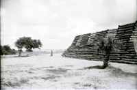
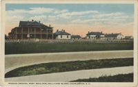
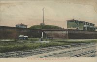
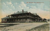
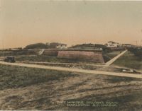
A postcard of the Parade Ground of Fort Moultrie. The back of the postcard reads, "The parade ground of Fort Moultrie, situated on Sullivan's Island was first called Fort Sullivan and later named after General Moultrie. It was originally built of palmetto logs and sand, and here Sergeant Jasper amidst shot and shell, jumped over parapets onto the beach, rescued the flag and put in place again."
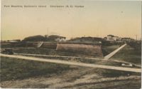
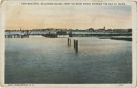
A postcard of Fort Moultrie near the Charleston Harbor on Sullivan's Island. The back of the postcard reads, "This fort is built on the site of the palmetto log and sand bag fort which repulsed the British fleet on June 28, 1776."
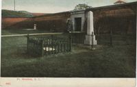
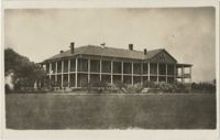
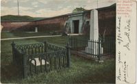
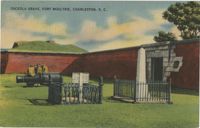
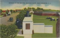
A postcard of the entrance of Fort Moultrie and the Grave of Osceola. Back of the postcard reads, "Osceola, a famous chief of the Seminole Indians, was born in Florida in 1803. His wife was seized as a slave in 1835, and he began a war which carried on until he was captured. He died in Fort Moultrie in 1837. Fort Moultrie, on Sullivan's Island, has figured extensively in history. During the Civil War the Fort was abandoned, when Charleston Harbor was evacuated in 1865."
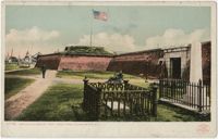
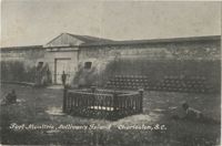
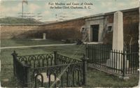
A postcard of the entrance to Fort Moultrie. The back of the postcard reads, "Fort Moultrie successfully defended the Harbor against the British Fleet under Sir Peter Parker. Th[illegible] shows the old guns left from past [illegible]ave of Osceola, famed Indian chief, [illegible] the modern coast artillery head-q[uarters]."