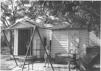
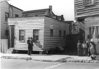
Two sheds and swing set, with standing girl, on site affected by the construction of Interstate 26 (I-26). Address: 2124 Weaver Avenue. Surveyor notations on back of photo: "Dkt.: 10.490. Property owner: Harry L. Rumph, Jr. Tract: 188. Station: 30' Lt. Sta. 5886-55. Date: May 15, 1962. In R/W - Bought." [See collection description for explanation of surveyor notations.]
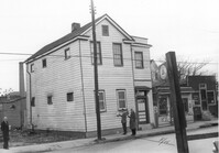
Side view of corner grocery store on site affected by the construction of the Crosstown. Address: 121 America Street. Surveyor notations on back of photo: "Dkt.: 10.518. Property owner: Vallie Talbert. Tract: 58. Station: 49+50 Lt. N.B. lane Route 17. Date: Mar. 7, 1963." [See collection description for explanation of surveyor notations.]
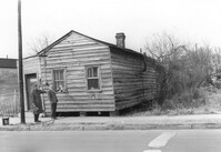
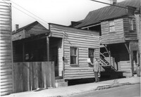
House (freedman's cottage) on site affected by the construction of the Crosstown. Address: 115 America Street. Surveyor notations on back of photo: "Dkt.: 10.518. Property owner: Jerusalem Baptist Church. Tract: 60. Station: 49+60 Rt. N.B. lane Route 17. Date: Mar. 7, 1963." [See collection description for explanation of surveyor notations.]
House (and neighboring buildings) on site affected by the construction of the Crosstown. Address: 60-58 Aiken Street. Public Telephone sign in foreground. Surveyor notations on back of photo: "Dkt.: 10.518. Property owner: Congaree Jenkins, Est. Tract: 54. Station: 48+00 Rt. N.B. lane Route 17. Date: Mar. 7, 1963." [See collection description for explanation of surveyor notations.]
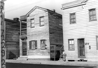
House on site affected by the construction of the Crosstown. Address: 68 Cooper Street. (Number on building is 78.) Surveyor notations on back of photo: "Dkt.: 10.518. Property owner: Ester Bosser. Tract: 42. Station: 44+65 Rt. line 9 north of Cooper Street. Date: Mar. 6, 1963. In R/W - Bought. [See collection description for explanation of surveyor notations.]
House on site affected by construction of the Crosstown. Address: 68 Cooper Street. (Number on building is 78.) Surveyor notations on back of photo: "Dkt.: 10.518. Property owner: Ester Bosser. Tract: 42. Station: 44+65 Rt. line 9 north of Cooper Street. Date: Mar. 6, 1963. In R/W - Bought. [See collection description for explanation of surveyor notations.]
House on site affected by the construction of the Crosstown. Address: 59 Lee Street (corner of Lee Street and Hanover Street). Surveyor notations on back of photo: "Dkt.: 10.518. Property owner: Melvin Whaley. Tract: 40. Station: 44+35 Rt. S.B. lane Route 17. Date: Mar. 6, 1963. In R/W - Bought. [See collection description for explanation of surveyor notations.]
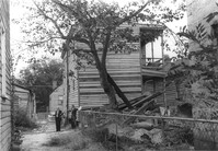
House on site affected by the construction of the Crosstown. Address: 88 Hanover Street. Surveyor notations on back of photo: "Dkt.: 10.518. Property owner: Jerusalem Baptist Church. Tract: 43. Station: 43+90 CL line 9 north of Cooper Street. Date: Mar. 6, 1963." [See collection description for explanation of surveyor notations.]
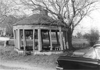
Gazebo, on site affected by the widening of Route 171 (Folly Road). Surveyor notations on back of photo: "Dkt.: 10.494. Property owner: Sophie Sabel, Est. Tract: 97. Station: 370+50 Lt. Date: Mar. 21, 1962. In R/W - Bought. [See collection description for explanation of surveyor notations.]
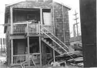
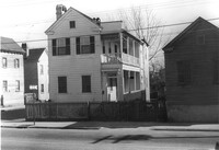
Rear view of house on site affected by the construction of the Crosstown. Address: 5 Rosemont Street. Backyard strewn with wood boards, etc. Surveyor notations on back of photo: "Dkt.: 10.524. Property owner: Harold I. Sherman. Tract: 53. Station: 71+20 Rt. Date: Oct. 14, 1964. Portion in R/W already torn down by property owner." [See collection description for explanation of surveyor notations.]