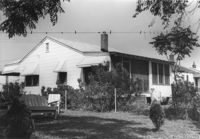
House (corner view, rear) on site affected by the construction of Interstate 26 (I-26). Surveyor notations on back of photo: "Dkt.: 10.480. Property owner: H.L. DuPuis Sr. Tract: 274. Station: 5725+90 Rt. (Line C). Date: May 31, 1961. In R/W - Bought." [See collection description for explanation of surveyor notations.]
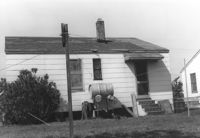
House (rear view) on site affected by the construction of Interstate 26 (I-26). Surveyor notations on back of photo: "Dkt.: 10.480. Property owner: William R. Hankins. Tract: 275. Station: 5726+40 Rt. (Line C). Date: May 31, 1961. In R/W - Bought." [See collection description for explanation of surveyor notations.]
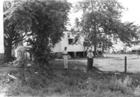
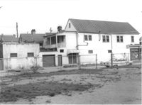
House (rear view) and yard, on site affected by the construction of Interstate 26 (I-26). Surveyor notations on back of photo: "Dkt.: 10.480. Property owner: Mrs. Lila Hutto. Tract: 280. Station: 5729+00 Lt. (Line C). Date: May 31, 1961. Proximity." [See collection description for explanation of surveyor notations.]
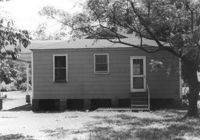
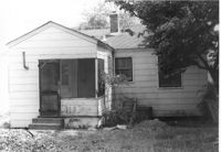
House (rear view) on site affected by the construction of Interstate 26 (I-26). Surveyor notations on back of photo: "Dkt.: 10.480. Property owner: C.G. Hudson. Tract: 251. Station: 5706+70 Lt. Date: May 31, 1961. In R/W - Bought." [See collection description for explanation of surveyor notations.]
Side of building on site affected by the construction of the Crosstown. Address: 186 Spring Street. (See following two photographs.) Lot across the street in foreground. Surveyor notations on back of photo: "Dkt.: 10.524. Property owner: Mona G. Sokol. Tract: 25. Station: 65+60 CL Lt. Date: Oct. 13, 1964. In R/W - Bought." [See collection description for explanation of surveyor notations.]
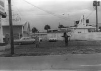
Lot and Kentucky Fried Chicken, on site affected by the construction of the Crosstown. Address: 223 Spring Street. Patio [restaurant?] in background. Surveyor notations on back of photo: "Dkt.: 10.524. Property owner: Arco Investment Co. Tract: 160 and 161. Station: 17±50 Rt. Spring Street. Date: Dec. 2, 1964." [See collection description for explanation of surveyor notations.]
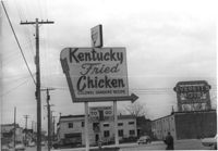
Sign for Kentucky Fried Chicken, on site affected by the construction of the Crosstown. Address: 223 Spring Street. Everett's Motel in background. Surveyor notations on back of photo: "Dkt.: 10.524. Property owner: Arco Investment Co. Tract: 160 and 161. Station: 17±50 Rt. Spring Street. Date: Dec. 2, 1964." [See collection description for explanation of surveyor notations.]
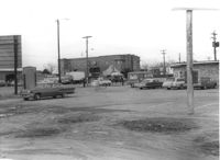
Partial view of The Fork (restaurant) and lot on site affected by the construction of the Crosstown. Address: 223 Spring Street. James Hotel [Hotel James] in background. Surveyor notations on back of photo: "Dkt.: 10.524. Property owner: The Fork Co. Inc. Tract: 156. Station: 13±00 Rt. Spring Street. Date: Dec. 2, 1964." [See collection description for explanation of surveyor notations.]
Wood-sided building on site affected by the construction of Interstate 26 (I-26). Building address number 4804. Neon sign for a Drive In (__MANER'S) (name partly illegible) in front. Billboard for First National Homes (4800 Rivers Ave.) next to building. Possibly on Rivers Avenue. Surveyor notations on back of photo: "Dkt.: 10.486. Property owner: Redding F. Moore. Tract: 23, 24, 25. Station: 15+50 Rt. (Line C). Date: May 30, 1961. In R/W - Bought." [See collection description for explanation of surveyor notations.]
House (rear view) on site affected by the construction of Interstate 26 (I-26). Address: 2128 Montford Avenue. Surveyor notations on back of photo: "Dkt.: 10.490. Property owner: Chas. W. Jenkins, Jr. [Charles W. Jenkins, Jr.]. Tract: 174. Station: 35' Lt. Sta. 5884+60. Date: May 15, 1962. In R/W - Bought." [See collection description for explanation of surveyor notations.]