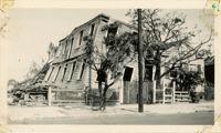
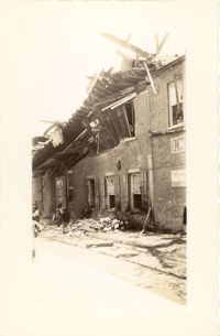
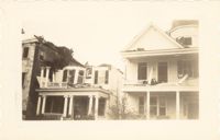
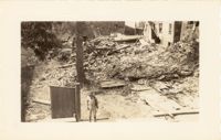
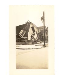
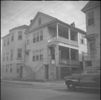
Photograph of a house on Fishburne Street demolished by the tornado of 1938. Neighboring house in view at left. (Both houses would have been on the north side of the 200 block of Fishburne Street.) Handwritten on back of photo: "2nd tornado on Fishburne Street near President Street. Demolished about 60 houses here. This 2nd tornado damage about $6,000,000. 300 houses condemned. Sept. 29, '38."
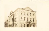
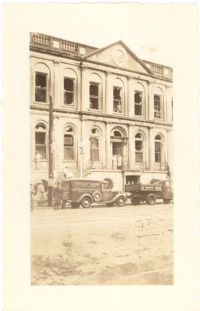
Photograph of the Charleston County Courthouse after the tornadoes of September 29, 1938, showing the damage done to the building. View of the corner elevation (Meeting Street and Broad Street). People who are standing inside the building at the second and third story windows can be seen. To the left of the Courthouse, the Hebrew Orphanage (88 Broad Street) is also in view.
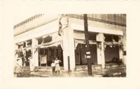
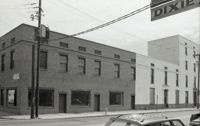
Photograph of a commercial building on a Church Street corner after the tornadoes of September 29, 1938, showing the damage done to the building. Probably located at the corner of Church and North Market Street or South Market Street. Onlookers stand on sidewalk.
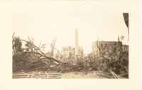
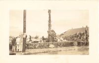
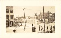
Photograph of Washington Square Park after the tornadoes of September 29, 1938, showing debris and fallen trees in the foreground; Washington Light Infantry monument in the middle; and the Meeting Street fire tower and Chalmers Street buildings in the background.
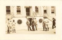
Photograph of City Hall after the tornadoes of September 29, 1938, showing the damage done to the building. Infantry patrolmen and other men stand in front of building.
Photograph of the wreckage of the Calvary Baptist Church, an African-American church demolished by the tornado of September 29, 1938. Located at the corner of Sumter Street and Ashley Avenue; address may have been 387 Sumter Street. Handwritten on back of photo: "Old Negro church on Sumter Street, corner of Ashley Avenue. This was done by second tornado that hit 2 miles from the other one. Sept. 29, 1938."
Photograph of the I.M. Pearlstine Building on Cumberland Street, located between East Bay and State Street, after the tornadoes of September 29, 1938, showing the damage done to the building. Portion of signage is visible at the right of the photograph, "I.M." and "Budwe[iser]"; signage for "Rex" is also on building (at left). Onlookers stand among the debris on the street.
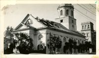
Photograph of First Scots Presbyterian Church [57 Meeting Street] after the tornadoes of September 29, 1938, showing the damage done to the building. The Nathaniel Russell House can be seen in the background. Cars are parked on the street in front of the church.
Photograph of the ruins of a building on King Street after the tornadoes of September 29, 1938. Shows the debris of a completely demolished structure and the damaged roof of the neighboring building. Based on newspaper accounts, this is probably the site of the Rectory of the Church of the Sacred Heart at King and Huger Streets. Three men stand on the sidewalk facing the debris; other men are standing on a pile of debris.
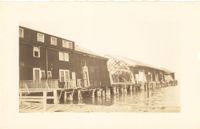
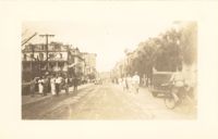
Looking east on Market Street after the tornadoes of September 29, 1938, showing the Market Sheds in ruins. A damaged car is parked along side of the debris. The Old Church of the Redeemer can be seen in the background.
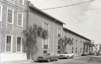
Photograph of 38 South Battery and 40 South Battery [Frederick Heinz Houses] and a portion of 42 South Battery, after the tornadoes of September 29, 1938, showing the damage done to the houses.
Photograph of City Hall after the tornadoes of September 29, 1938, showing the damage done to the building. Two trucks, including an Automatic Grocery truck, are parked in front of building. Onlookers are on the sidewalk in front of building; men stand at doorways and windows.
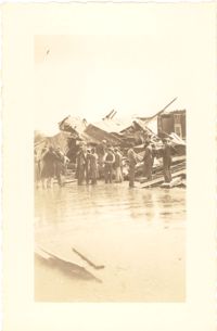
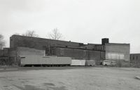
Photograph of the United Fruit Company dock after the September 29, 1938, tornadoes. (Based on Sanborn Maps, the dock was located at the foot of Laurens Street, Southern Railway Pier 2.)
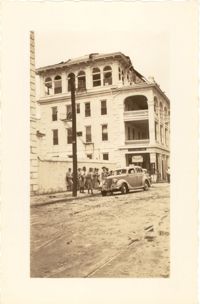
Photograph of the Timrod Hotel [ca. 101 Meeting Street], after the tornadoes of September 29, 1938, showing the damage done to the building. View of the hotel looking north on Meeting Street (southeast elevation). Infantry patrolmen stand on sidewalk by a car. Signage for Byars Drug Store is on the south elevation. [Note: The hotel was later demolished in the 1960s.]
Photograph of Broad Street, looking east at the 60 block, showing the scene on the street after the tornadoes of September 29, 1938. The Daniel Ravenel House (68 Broad Street), the Confederate Home, and the People's Building can be seen at the right; the Old Exchange Building is visible in the background. Onlookers, cars, and a person riding a bicycle are on the street.
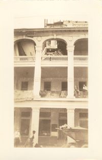
Photograph of the Timrod Hotel [ca. 101 Meeting Street], after the tornadoes of September 29, 1938, showing the damage done to the building. East elevation. Men are sitting on the second story piazza ledge. Men stand on the sidewalk by a truck that is carrying debris. [Note: The hotel was later demolished in the 1960s.]
Looking northwest on Market Street from the U.S. Custom House on East Bay Street, after the tornadoes of September 29, 1938, showing damaged and ruined Market Sheds. Also shows the damaged buildings on North Market Street. Onlookers and cars are in the street. Partial view of ca. 225 East Bay Street (now gone) is on the left.
Photograph of the ruins of a building, after the September 29, 1938, tornadoes. Based on newspaper accounts, it is probably the site of 45 State Street. Infantry patrolman stands in foreground.
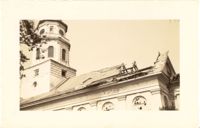
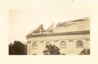
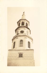
Photograph of St. Michael's Church after the first tornado of September 29, 1938, showing the damage done to the roof. Handwritten on back of photo: "Old historic St. Michael's Church, corner Broad Street and Meeting Street. Done by first tornado, Sept. 29, '38."
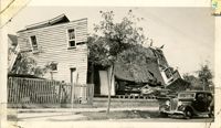
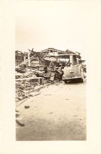
Photograph of the destruction of a house done by the tornadoes of September, 29, 1938. Based on newspaper accounts, the home was probably located in the Fiddlers' Green neighborhood near the Ashley River. Two men lean against the ruins while another man climbs a nearby telephone pole.
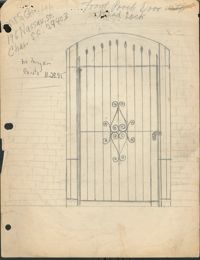
Original graphite sketching (8 1/2" x 11") of "Front Porch Door with Dead Lock," featuring heart shapes with scrolls in center and leaf points at the top
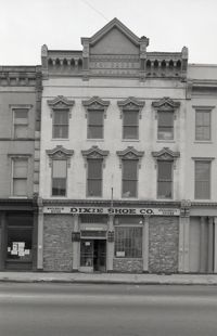
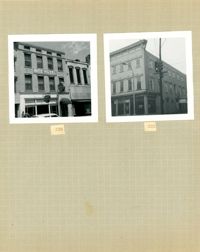
Black-and-white photograph of 196 Meeting Street, showing the southeast corner of Meeting Street and Hayne Street (left) and 190-194 Meeting (right). Sign for the business across the street in upper left of photo, Dixie [Shoe Company] (211 Meeting).
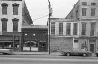
Black-and-white photograph of 199 Meeting Street (Ace Liquors Inc, formerly known as The Horse Shoe bar) and the view west across what was the location of Belk Department Store (232 King Street) and parking lot, now the site of Charleston Place (f/k/a Charleston Center). Shows buildings on the west side of King Street: 231 King, 233 King, 235 King, and 237 King.
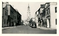
Looking north on Church Street from the northeast corner of Chalmers Street. Features buildings on the west side of the street: 129 Church, 131 Church, and the Dock Street Theater). Also in view are buildings on the east side of the street: 18 Chalmers Street, 132 Church Street, and St. Philip's Church). Cars are parked on the street.
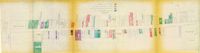
One of four maps of King Street building footprints, hand-colored to designate status. This map illustrates the historical significance of buildings on King Street from Calhoun Street to Columbus Street.
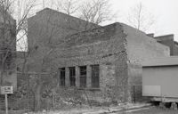
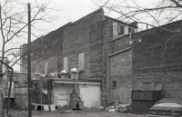
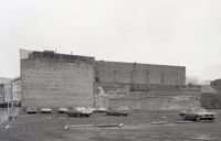
One of three black-and-white photographs of the structures at the rear of 238-242 King Street up to the rear of the buildings at about 199-203 Meeting Street, bordering what was the northern boundary of the Belk parking lot, and on the site where Charleston Center would be constructed.
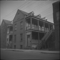
One of three black-and-white photographs of the side elevations of (possibly) 87 Hasell Street and its neighbor to the east at the time, 85 Hasell Street (gone). (87 Hasell Street currently borders the Hasell Street entry to Charleston Place and its parking garage.)
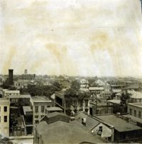
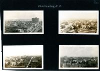
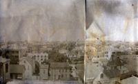
View of Charleston from rooftop at northeast corner of Wentworth and Meeting Streets, facing northwest. Page 22, Photo 2 of collection. 3.5" x 3.5" B/W photograph.
View of Charleston from rooftop at northeast corner of Wentworth and Meeting Streets, facing southwest. Church steeples in image include the Unitarian Church and St. John's Lutheran Church. Page 2, Photo 2 of collection. 3.5" x 3.5" B/W photograph.
View of Charleston from rooftop in the vicinity of northeast corner of Meeting and Wentworth Streets, facing northeast. Page 4, Photo 2 of collection. 3.5" x 3.5" B/W photograph.
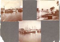
Three photographs on page. Top left and bottom: View from the Cooper River of the piers and boats on the Charleston waterfront behind the U.S. Customhouse. The Customhouse can be seen in the background as well as Market Street buildings. Top right: Unidentified beach scene, possibly Isle of Palms.
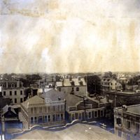
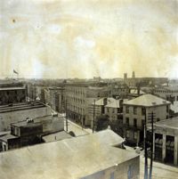
Four aerial views of Charleston looking across the peninsula. Top left: Looking northeast, possibly from St. Michael’s Church, showing Broad Street and the area to its north bounded by East Bay Street, and possibly Queen Street. Cars are parked along the street. Landmarks include the Confederate Home and its rear dormitory apartments, People's Building, Old Exchange Building, and the corner of Broad and Church Streets showing the Bank of South Carolina Building (50 Broad Street) before it was restored. A faint view of the U.S. Customhouse is at the far left. Top right: Looking southeast, possibly from the Francis Marion Hotel, with Meeting Street bisecting the view at a diagonal. Landmarks include the U.S. Customhouse, Charleston Hotel, People’s Building, and St. Philip’s Church. Bottom left: Looking south on King Street, possibly from the Francis Marion Hotel, showing King Street from approximately 360 King down to the bend near Market Street, and the view east of King Street. Vehicles can be seen on King Street. Landmarks include the Masonic Temple Building (270 King Street), the tower of the Peoples First National Bank Building (also known as the Hirsh Israel Building, 275 King Street), and the Hotel Calhoun (238-242 King Street). Bottom right: Looking southwest, possibly from St. Michael’s Church, toward James Island. Landmarks include the Fort Sumter House (1 King Street), Col. John Ashe House (32 South Battery), rear of First Scots Presbyterian Church (57 Meeting Street), Miles Brewton House (27 King Street), and the north elevation of the John E. Poyas House (69 Meeting Street).
View of Charleston from rooftop of Calhoun Mansion, facing north. Page 3, Photo 2 of collection. 5.5" x 3.75" B/W photograph, two images spliced together.
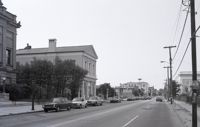
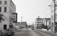
Black-and-white photograph of the view north on Meeting Street toward Market Street, from the 135 Meeting (Gibbes Art Gallery) and 141 Meeting (Charleston Gas Light Co. Building) at left.
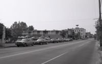
Black-and-white photograph of the Heart of Charleston Motor Hotel at 200 Meeting Street, between Hayne Street and Pinckney Street. Corner view of building (northeast elevation) and view of the southeast corner of Meeting and Pinckney. (Previously the site of The Charleston Hotel (1838-1960) and currently the site of the Bank of America Building.)
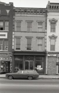
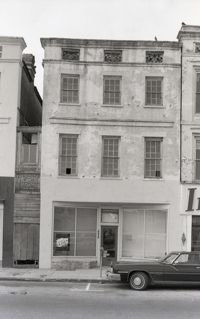
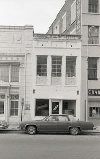
Black-and-white photograph of 207 Meeting Street, street (front) elevation before its demolition for the construction of Charleston Place (formerly known as Charleston Center). (At the time of this photograph, Its neighbor at 205 Meeting Street had already been demolished.)
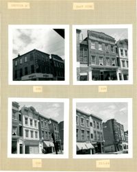
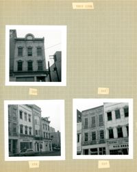
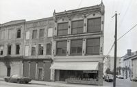
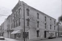
Four B&W photographs of buildings on the east side of King Street: Top left: 220 King Street (Dumas); Top right: 218 King Street (Sharnoff's Uniform Shop); Bottom left (212-218): 212 King Street, 214 King Street (Fabric Center), 216 King Street, and edge of 218 King Street; Bottom right (208-214): 208 King Street (Gatlin Opticians), 212 King Street (La Scaltro Antiques), and 214 King Street (Fabric Center).
Black-and-white photograph of the view north on Meeting Street toward Market Street, from the parking lot of the White Horse Inn. The Golden Eagle Motor Inn next door is also in view.
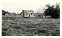
In this one-page typed document eight houses and gardens are added to the walking tour through the Ansonborough Neighborhood: 19 Wentworth Street, 57 Anson Street, 46 Society Street,43 Society Street, 63 Anson Street, 75 Anson Street, and 79 Anson Street. An approximate date of when the buildings on the property were built, as well as ownership information, is included.
Black-and-white photograph of the Meeting Street elevation (west elevation) of what would become the Indigo Inn. Signage atop protective construction walkway says "[illegible] Development by Limehouse Properties: Indigo Inn, 47 Luxurious Units Opening Nov. 1 to Accommodate the Most Discriminating." Building is located at the southeast corner of Meeting Street and Pinckney Street, with the current address 1 Maiden Lane.
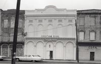
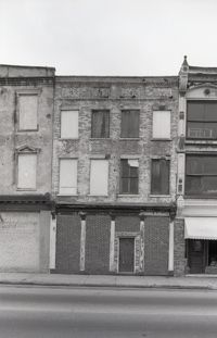
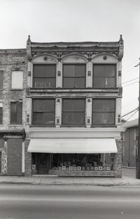
Three B&W photographs of buildings on the west side of King Street, demolished for the construction of Majestic Square: Top left: 223 King Street (Ocean Grill); Top right: 221 King Street (photograph is missing); Bottom left (219-223): 219 King Street (Rice Bros.), 221 King Street, and 223 King Street (Ocean Grill); Bottom right (217-219): 217 King Street and 219 King Street (Rice Bros.).
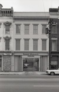
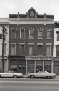
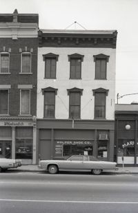
Black-and-white photograph of 219 Meeting Street (Mari Anne [restaurant]), 221 Meeting Street, street (front) elevation. Portions of adjacent buildings on either side, 217 Meeting Street (Wolper Shoe Co.) and 223 Meeting Street (Clair's Lucky Dollar Grocery Store) also in view.
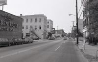
Black-and-white photograph of the view north on Meeting Street toward Market Street, from the Golden Eagle Motor Inn. Madren Paint Co. (177 Meeting) also in view.
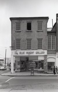
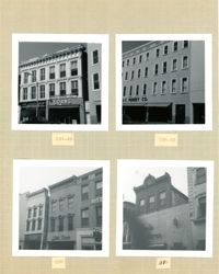
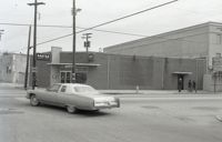
Black-and-white photograph of 220 King Street (Nathan Hart Building), street (front) elevation, with signage for Blue Knight Gallery. Also shows view of street corner (Market Street and King Street).
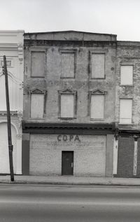
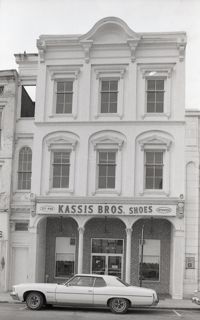
Two B&W photographs of buildings on the east side of King Street, both demolished for the construction of Charleston Place: Left (224-226): 224 King Street and 226 King Street (Ritz Hotel); Right: 222 King Street (Copa Lounge) (northeast corner of King and Market).
Four B&W photographs of buildings on the east side of King Street, including some that were demolished for the construction of Charleston Place: Top left (244-246): 244 Coastal Finance Loans and 246 King Street (The Linen Shop) demolished; Top right: 238-242 King Street (J.C. Penney Company) ? demolished; Bottom left (226-230): 226 King Street (Ritz [Hotel]), 228 King Street (Little Town), and 230 King Street demolished; Bottom right: 316 King Street (Rosalie Meyers) [labeled 318 on album page].
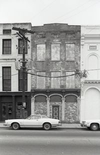
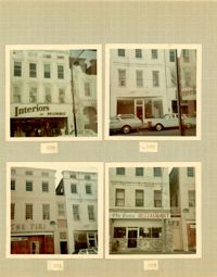
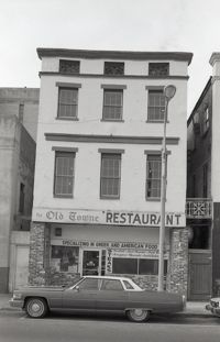
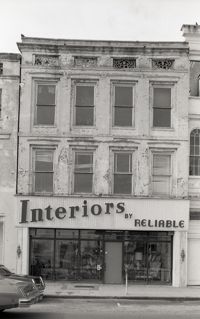
Four color photographs of buildings on the west side of King Street: Top left: 235 King Street (Interiors); Top right: 233 King Street; Bottom left: 231 King Street (The Tiki); Bottom right: 229 King Street (Old Towne Restaurant)
Black-and-white photograph of the view north from the intersection of Meeting Street and Market Street. Madren Paint Co. (177 Meeting) at left; First Citizens Bank (182 Meeting), Market Hall, and 112 North Market at right.
Left to right: 23 Society Street and 25 Society Street, later demolished. The houses were at the southwest corner of Society Street and East Bay Street.
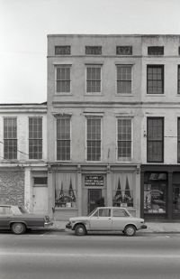
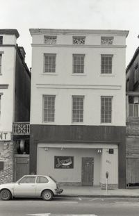
Black-and-white photograph 231 Meeting Street (Copa), 233 Meeting Street, and 235 Meeting Street, street (front) elevation. Shows the southwest corner of Meeting Street and Hasell Street, Kerrison's building in background.
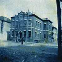
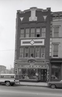
Black-and-white photograph of 232 Meeting Street (Western Union), located at the southeast corner of Meeting Street and Hasell Street. (Currently the site of FIG restaurant.)
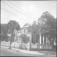
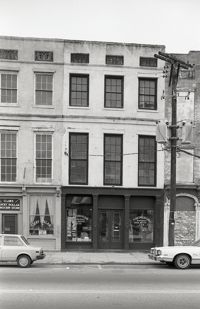
Black-and-white photograph of the northwest elevation of 235 Meeting Street. Shows the corner of Meeting and Hasell Streets and the north elevation of the building that extends west on Hasell Street. "Picture Framing" signage over window. Also shows neighboring buildings to the south in the view down Meeting. (Currently the site of Sticky Fingers Restaurant.)
Black-and-white photograph of the view looking north on Meeting Street from the corner of Meeting and Hasell Streets. The Best Western King Charles Hotel (237 Meeting) is in foreground. Meeting Street buildings leading to Wentworth Street at right.
Black-and-white photograph of the view looking east on Hasell Street showing the Hasell Street elevation (south elevation) of the Best Western King Charles Hotel (237 Meeting Street).
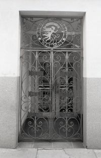
Decorative ironwork door, the side entry to 238-242 King Street. Ironwork features circular Washington Light Infantry emblem "Valor and Virtue - Washington - W.L.I. 1807," with six small iron panels with the years 1812, 1836, 1847, 1861, 1917, and [1941?].
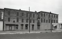
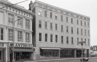
Black-and-white photograph of 238-242 King Street (previously the Hotel Calhoun) and 244 King Street (Annette Sandburg Antiques), street (front) elevation. Now the site of Charleston Place. Street sign for the intersection of Beaufain and King in foreground.
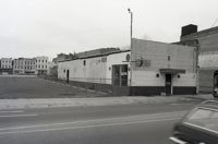
Black-and-white photograph of the view looking north across what was the location of Belk Department Store and parking lot (232 King Street), now the site of Charleston Place (formerly known as Charleston Center). Shows the southeast elevation of 238-242 King Street.
One of three black-and-white photographs of the structures at the rear of 238-242 King Street up to the rear of the buildings at about 199-203 Meeting Street, bordering what was the northern boundary of the Belk parking lot, and on the site where Charleston Center would be constructed.