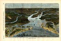
[Color image.] Caption (in French): 'Evenements des Etats-Unis: Charleston et ses fortifications. [Events of the United States: Charleston and its fortifications.] 1--Charleston. 2--Riviere Ashley [Ashley River]. 3--Chemin de fer de Savannah [Savannah Railway]. 4--Riviere Cooper [Cooper River]. 5--Riviere Wando [Wando River]. 6--Fort Pinkney [Castle Pinckney]. 7--Fort Ripley. 8--Fort Johnson (ile James) [James Island]. 9--Riviere Stone [Stono River]. 10--Fort Sumter. 11--Fort Moultrie. 12--Batterie Gregg (pointe de Gumming) [Battery Gregg (Cummings Point)]. 13--Fort Wagner. 14--Batteries rasantes du general Gilmore [grazed batteries of General Gilmore]. 15--Ouvrages pris par les federaux. [Works undertaken by the Federals]. 16--Phare Inlet [Lighthouse inlet]. 17--Batteries federales (ile Folly) [Federal Batteries (Folly Island)]. 18--Canonnieres et vaisseaux cuirasses [gunboats and ironclads]. 19--Hotel. 20--Ile et batteries Sullivan [Sullivan Island and Batteries]. 21--Moultrie. 22--Mont Pleasant [Mount Pleasant]. 23--Breach Inlet. 24--Shem Creek. 25--Batteries construite par les confederes sur l'ile James, dans le voisinage du fort Johnson [Batteries built by the Confederates on James Island, in the vicinity of Fort Johnson].
[Color image.] Caption: 'The citizens of Charleston, S.C., deserting their homes, on the threatened attack of the city by the Federal Forces. From a Sketch by Lieutenant G.P. Kirby.'
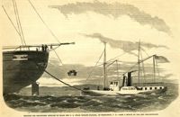
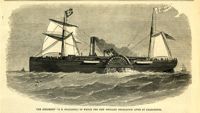
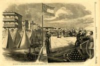
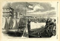
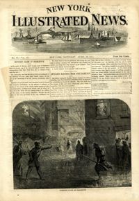
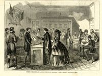
Caption: 'Shipping the recaptured Africans on board the U.S. steam frigate Niagara, at Charleston, S.C.--from a sketch by our own correspondent.' [full date Oct. 9, 1858]
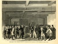
Caption: 'The city of Charleston, South Carolina, where the Democratic Nominating Convention will be held.--[see preceding page.]' [full date April 21, 1860.]
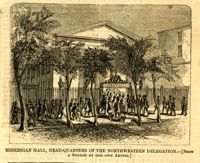
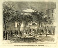
Caption: 'The Charleston Convention--interior of Douglas's headquarters, Hibernia (sic) Hall, Charleston, S.C.--from a sketch by our special artist.--see page 360.' [May 5, 1860.]
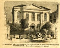
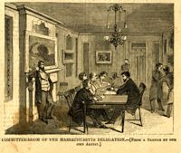
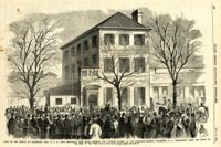
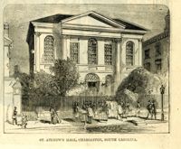
Caption: 'St. Andrew's Hall, Charleston, head-quarters of the Wood Delegation at Charleston.--[from a sketch by our own artist.]' [full date May 5, 1860.]
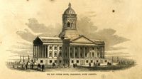
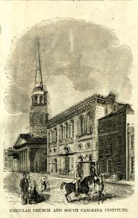
[Color image]. Caption: 'The South Carolina Institute, at Charleston, South Carolina, in which the Democratic Convention will meet.--[see preceding page.]' [full date April 21, 1860.]
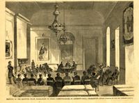
Caption: 'Meeting of the rejected Wood delegation in their committee-room, St. Andrew's Hall, Charleston.--[from a sketch by our own correspondent.] [full date May 5, 1860.]
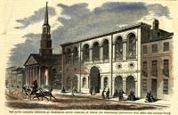
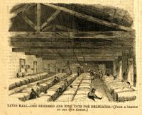
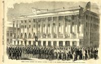
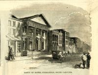
Caption: 'The Charleston Convention--view of the South Carolina Institute building, in Meeting Street, Charleston, S.C., where the Democratic Convention will hold its meeting during the present month of April.--from a sketch by our Special Artist.--see page 804.' [full date April 14, 1860.]
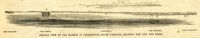
Caption: 'Profile view of the harbor of Charleston, South Carolina, showing the city and forts.' Identified in the image: Fort Johnston (sic), Fort Sumter, Charleston, Fort Moultrie and Mount Pleasant. [full date December 29, 1860.]
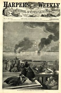
Caption: 'The Battery or Park Promenade at Charleston, South Carolina, during the bombardment of Fort Sumter--Sketched by our Special Artist--[see next page].' [full date May 18, 1861.]
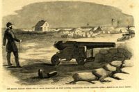
Caption: 'Caption: 'The rifled cannon which did so much execution on Fort Sumter, Charleston, South Carolina'--[From a Sketch by our Special Artist.]' [full date May 18,1861.]
Caption: 'The Battery or Park Promenade at Charleston, South Carolina, during the bombardment of Fort Sumter--Sketched by our Special Artist--[see next page].' [full date May 18, 1861.]
Caption: 'Scene on the arrival of Lieutenant Hall, U.S.A., with despatches (sic) from Major Anderson for Governor Pickens, at the Executive Mansion, Charleston, S.C., immediately after the firing on the Star of the West.--from a sketch by our Special Artist.--see page 151.' [full date January 26, 1861.]
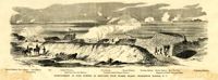
Caption: 'Bombardment of Fort Sumter, as sketched from Morris Island, Charleston Harbor, S.C.' Identified in image: Mortar Battery, Fort Johnson; James Island; City; Castle Pinckney; Fort Sumter; Mount Pleasant; Floating Battery; Mortar Battery; Fort Moultrie; Enfilading Battery; Iron Battery; Sand-bag cover for reserve; Traverse behind Trapier Battery and Magazine covered with sand bags.
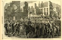
Caption: 'General McGowan addressing the Abbeville Volunteers in front of the Charleston Hotel--from a sketch by our Special Artist now in Charleston.' [full date February 23, 1861.]
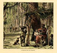
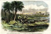
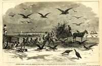
[Color image.] Caption: 'Negroes hunting the moccasin snake on the Ashley River, near Charleston, S.C.--from an original sketch by Granville Perkins, Esq.' [full date April 13, 1861.]
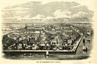
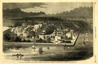
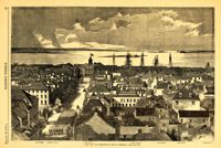
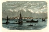
Caption: 'The city of Charleston, South Carolina.--[see page 62.]' Also identified in image: Broad Street, "Mercury" office, Custom-house, Castle Pinckney, Fort Moultrie, Fort Sumter and Morris Island. [full date January 26, 1861.]
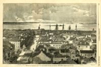
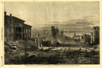
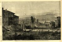
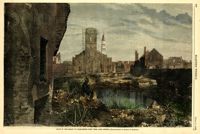
Caption: 'The city of Charleston, South Carolina, looking seaward, and showing the burned district.--[see next page.]' Identified in image are: Broad Street, "Mercury" office, Custom-house, Castle Pinckney, Fort Moultrie, Fort Sumter and Morris Island. [full date December 28, 1861.]
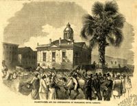
Caption (in German): 'Grosse Bersammlung von Seceders vor dem Stadthause in Charleston, S.C.' {Large crowd of Secessionists in front of City Hall, Charleston, S.C.}
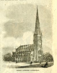
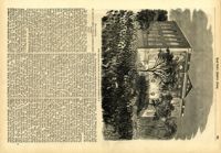
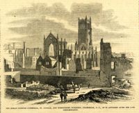
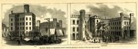
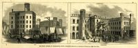
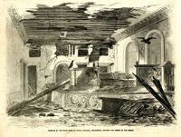
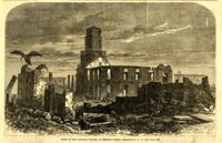
Caption: 'The Roman Catholic Cathedral, St. Finbar, and surrounding buildings, S.C., as it appeared after the late conflagration.' [full date November 1, 1862.]
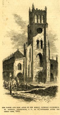
Caption: 'The tower and side aisle of the Roman Catholic Cathedral, St. Finbar, Charleston, S.C., as it appeared after the Great Fire, 1862.' [full date November 1, 1862.]
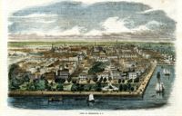
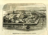
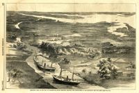
Caption: 'Birds-eye view of the city of Charleston, South Carolina, showing the approaches of our gun-boats and our army.--[see page 431.]' [full date July 5, 1862.]
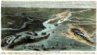
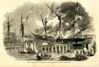
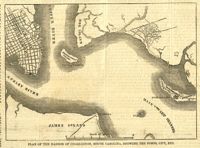
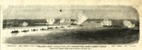
Caption: 'Panoramic view of Charleston Harbor--advance of iron-clads to the attack, April 7. Union--A. Keokuk. B. Nahunt. C. Nantucket. D. Catskill. E. Ironsides. F. Patapsco. G. Montauk. H. Passaie. K. Weehawken. Rebel--1. Morris Island sand battery. 2. Fort Wagner. 3. Battery Bee, on Cummings Point. 4. [Fort] Johnson. 5. Fort Ripley. 6. Sumter. 7. Charleston City. 8. Castle Pinckney. 9. Fort Redan. 10. Fort Moultrie. 11. Moultrie House. 12. Fort Beauregard. 13. Harbor obstructions. 14. Cooper River. 15. Ashley River.' [full date May 2, 1863.]
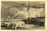
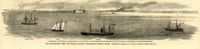
Caption: 'Our blockading fleet off North Channel, Charleston Harbor, South Carolina.--sketched by a Naval Officer.--[see page 79.] References--A. Fort Sumter.--B. Charleston City.--C. Fort Moultrie.--D. Rebel tug at work on the obstructions.--E. Obstructions.--F. Fort Johnson.--G. Mount Pleasant Batteries.' Also identified in image: South Carolina, Blunt, Daylight and Stars and Stripes (ships of the fleet). [full date January 31, 1863.]
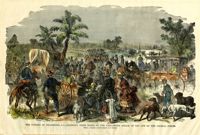
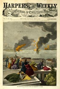
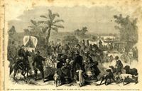
Caption: '"The Grand Skedaddle" of the inhabitants from Charleston, S.C., when threatened by an attack from the Union troops.--from a sketch by Lieut. G.P. Kirby, 47th N.Y.V., when a prisoner in Charleston.--see page 270.' [full date January 17, 1863.]
Caption: 'Quarters of the Union officers exposed to the Federal fire in Charleston.--sketched by one of the Officers.--[see page 550.]' [full date August 27, 1864.]
Caption: 'Quarters of the Union officers exposed to the Federal fire in Charleston.--sketched by one of the Officers.--[see page 550.]' [full date August 27, 1864.]
Caption: 'Military Prisons at Charleston, South Carolina.--Sketched by Lieutenant F. Milward--[See Page 110]' The Jail and Work-House are both identified.
Caption: 'Remains of the new bridge over Ashley River, Charleston, S.C., partially destroyed by the Rebels on the evacuation of the city, Feb 18, 1865.--from a sketch by our Special Artist, W.T. Crane.' [full date June 10, 1865.]
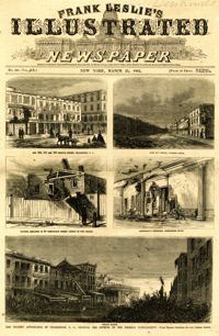
Main caption: 'The present appearance of Charleston, S.C., showing the effects of the Federal bombardment.--from recent sketches by our special artist.' Caption top left: 'Nos.165, 167 and 169 Meeting Street, Charleston, S.C.' Caption top right: 'East Bay Street, looking south.' Caption middle left: 'Kitchen attached to 53 Wentworth Street--effect of two shells.' Caption middle right: 'Gentleman's ordinary, Charleston Hotel.' Caption bottom: 'Vendue Range.' [full date March 25, 1865.]
Caption: 'Military Prisons at Charleston, South Carolina.--Sketched by Lieutenant F. Milward--[See Page 110]' the Jail and Work-House are both identified. [full date February 18, 1865.]
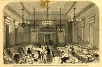
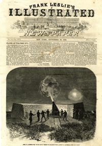
[Color image.] Caption: 'Feeding 8,000 people with rations of rice and salt at West Point Mills, on the Ashley River, Charleston S.C.-- From a sketch by our Special Artist, W.T. Crane.' [full date April 15, 1865.]
Caption: ' "Marching on!"--the Fifty-Fifth Massachusetts Colored Regiment singing John Brown's March in the streets of Charleston, February 21, 1865.--[see page 172.]' [full date March 18, 1865.]
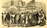
Caption: 'Enthusiastic crowd of citizens of Charleston, S.C., assembled on Vanderhost's (sic) Wharf, Feb. 20, to greet the second visit of Gen. Gillmore and staff.--sketched by our Special Artist.' [full date March 25, 1865.]
Caption: 'Southern scenes.--fight for garbage in the streets of Charleston between the scavengers (turkey-buzzards) and the Negroes.' [full date December 11, 1869.]
Caption: 'Sketches in Charleston, South Carolina. 1.Cotton Day. 2. A Limb of the Law. 3. Gossips. 4.Light-wood cart. 5. "A Relic". 6. Milk Girl.7. In the Market-Poultry Dealer. 8."Horse" Car.' [full date July 17, 1875.]
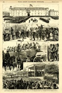
Caption: '1. Assembling on the Citadel Parade. 2. Watching the Procession. 3. The Boy Drum Corps. 4. The Thirteen States. 5. The Union League. 6. Reading the Emancipation Proclamation on the Battery. South Carolina--the celebration of Emancipation Day, January 8th. in Charleston--scenes and incidents of the parade--see page 375.' [full date February 10,1877]
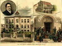
[Color image.] Caption: 'The Avery Institute, Charleston, South Carolina.--[see page 867.]' Also identified in image: Rev. Charles Avery and Teachers' Home.
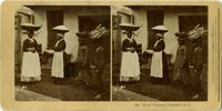
A stereoscopic image of African American women holding baskets with wares on top of their heads and children carrying wares atop their head. The text at the bottom of the image identifies them as "street vendors."
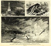
Main caption: 'South Carolina.--scenes in the track of the cyclone which devastated Charleston, August 25th. See page 43. 1. St. Michael's Church [upper left]. 2. Scene on the water front after the storm [top right]. 3. Destruction on South Battery [bottom].' [full date September 5, 1885.]
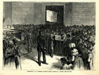
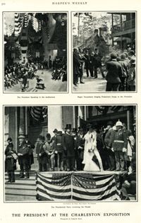
Main caption: 'The President at the Charleston Exposition. Photographs by Frederick Moore.' Caption top left: 'The President speaking in the auditorium.' Caption top right: 'Negro tea-pickers singing pickaninny songs to the President.' Caption bottom center: 'The presidential party reviewing the parade.' Further captioning identifies: 'The President, Sec. Wilson, Mayor Smythe, Mrs. Roosevelt.'
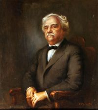
Framed oil portrait of Thomas Miller, African American lawyer, politician, and educator who was a South Carolina legislator, member of the U.S. House of Representatives, and first President of South Carolina State College (formerly the Colored Normal Industrial Agricultural and Mechanical College of South Carolina).
Framed oil painting, "Shrimp Vendor," depicting an African American man with a tray of shrimp walking by a house with iron fence and balcony, typical of Charleston homes. On long term loan to the Avery Research Center from St. Mark’s Episcopal Church.
One of three scrapbooks compiled by William Henry Johnson containing, among other materials, photographs depicting scenes of the South Carolina Lowcountry, with descriptive notes. Volume 1 includes photographs depicting cemeteries, churches, plantations, historic buildings, ruins, landscapes, and the interiors of buildings. Subjects include locations in Berkeley County, St. Johns (Berkeley) Parish, Goose Creek, and along the Cooper River. Other sites and subjects include Belmont, Black Oak Church, Bluford, Casada, Cedar Grove, Cedar Spring, Comingtee, a Prioleau family burial ground, Crowfield, Dean Hall Plantation, Dockon Plantation, Eutaw, Eutaw Springs, Exeter, Fairspring, Fort Dorchester, Four Hole Swamp, Gippy, Gravel Hill, the gravestone of Susan Bee, Hanover Plantation, Indian Fields Campground, Ingleside, Indianfield, Liberty Hall Club, Lewisfield, Magnolia Cemetery, monument of Col. Hezekiah Maham, grave of Major Majoribanks, Medway Plantation, Mepkin, a milestone by the Cooper River, Moorfield, Mount Pleasant Plantation, Mulberry Castle, North Hampton, Numertia, The Oaks Plantation, Ophir, Otranto Hunting Club, Parnassus, Pimlico, Pinegrove, Pond Bluff, Pooshee Plantation, John Poppenheim's plantation, Quarter house, Red Bank Hunting Club, an Episcopal church in Pineville, Rice Hope Plantation, The Rocks, St. James Goose Creek church, St. Johns Berkeley rectory site, St. Johns AME Church, a St. Julien family house, a Santee Canal lock, "Sarrazin house," a shanty, Somerset Plantation, Somerton Plantation, "Francis Marion spring," Springfield, Stoney Landing, Strawberry Chapel, Ten Mile Hill, Thoroughgood, Wadboo Barony, Wadboo bridge, Walnut Grove, Walworth, Wampee, Wampoolah, Wappetaw, Washington Plantation, the Whaley place, White Hall, Wiskinboo, Woodlawn, and Yeamans Hall.
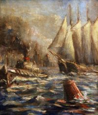
Untitled oil painting depicting a sailing vessel led by a tugboat. A buoy appears in the forefront and a city is visible in the background. Back of framed image reads "To our Friends The Sanfords; Xmas 1927; Elise and Teddy Harleston."
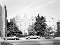
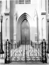
405 King Street, St. Matthews Lutheran Church, ca. 1867. Sunday School Building and Office Building - View of East (Front) elevation. 4" x 5" B/W photo.