FRONT: Plat is on the northside of the Ashley River. Contains 200 acres. BACK: Plat contains 36 acres on the North side of the Ashley River. Names associated with this plat are Richard Baker, Elibee Baker, John Baker, Josiah Baker, John Guptan, James Cantley [?], James Glen, John Stevens, Joseph Child, John Ainslee, Richard Baker, William Cattell and George Hunter. Notable geographic locations include St. George's Parish, Ashley River and Berkeley County.
169 acre plot given to Kent McCall, shows roads and surrounding neighbors, shows the Ashley River and some trees on the property borders. Names associated with this plat are Kent McCall, Thomas Parker, Roger Smith, Burnard Elliott, Crughtton, William Elliott, John Heard, Benjamin Dart, Elizabeth McCall, John Ward, John Parker, and Thomas Parker. Notable geographic locations include St. Andrew's Parish and the Ashley River.
Plan of a tract of land belonging to George Chisolm. Names associated with this plat are George Chisolm, John Scott, A. Andrew, Thomas Hollingsby [?], and Thomas. Notable geographic locations include the Ashley River and Kuskawah [Kushiwah] Creek.
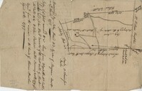
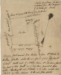
64 acre plot of land on the north side of the Ashley River, notes on the plat include some notes about stocks, shows surrounding tracts of lands, no land type or detail. Names associated with this plat are William Fuller, John Johnson, James Simmons, Stocks, William Fuller, George Smith, Henry Wood and John Hewson.
Copy of a plat part now belonging to Benjamin Perry and part to John Pringle on the west side of Ashley River. Names associated with this plat include John Pringle, Benjamin Perry, John Julius Pringle, Lambert Lance, Abraham Ladson, Sarah Rose, Nathaniel Bradwell, Ephraim Mitchell, Thomas Drayton, John Frazer, Frances Baker, Thomas Osborn, Isaac Landson, Isaac Perry, John Drayton, Glen Drayton, Francis Ladson and W. John Cattle. Notable geographic locations include the Ashley River, Charleston, Berkeley County, and Ashley River Road.
"Plan of a Plantation containing 240 acres in St. Andrew’s parish belonging to William Newbenny. Surveyed by N. Brandwill March 1772. Copy taken from the plan in the property of William Newbenny." The plat also contains the location of a structure and a road leading to it. Plantation located on East side of Ashley River. Names associated with this plat are William Mewhening, N. Brandwill, Whitenarth Tuller, William Scotts, Ralph Izard, the Lords Proprietors, William Williams and William Scott.
Work on paper in watercolor dated 1802. Large two-story house with white walls and blue roof in center. Large green lawn and tree to left in foreground.
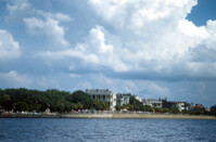
View of Battery Point (intersection of Murray Boulevard and East Battery Street) from the Ashley River. Charleston, S.C. Originals are 35mm color slides.
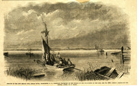
Caption: 'Remains of the new bridge over Ashley River, Charleston, S.C., partially destroyed by the Rebels on the evacuation of the city, Feb 18, 1865.--from a sketch by our Special Artist, W.T. Crane.' [full date June 10, 1865.]