Search
Search Results
Description:
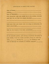
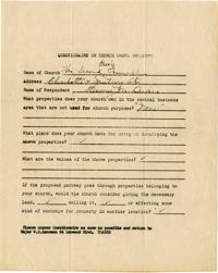
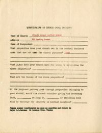
Blank questionnaire on church owned property.
Description:
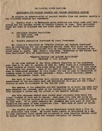
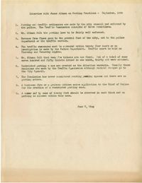
Memorandum for guiding traffic and parking for the committee on "Traffic Studies and Parking Practices," chaired by A.W. Allison.
Date:
1944-06-26
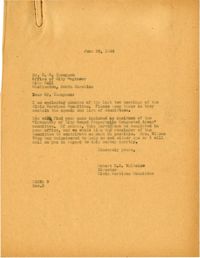
Description:
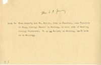
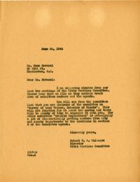
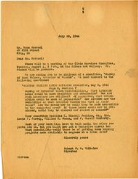
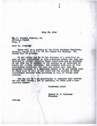
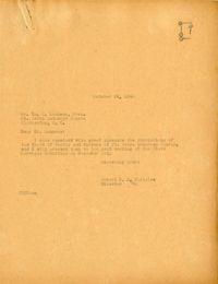
Letter to Rene Ravenel from Robert N.S. Whitelaw (June 26, 1944) regarding his parking/traffic survey committee assignments.
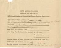
Description:
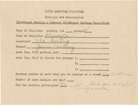
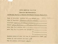
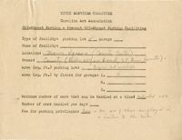
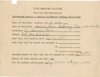
Off-street parking facilities survey filled out for Auto Livery Co. (Connelley's Storage Garage).
Description:
Notes regarding area 7 of the off-street parking facilities survey.
Description:
Map of Area 11of the off-street parking facilities survey.
Description:
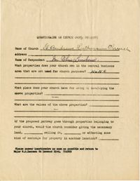
Church owned property questionnaire filled out for St. Andrew's Lutheran Church.
Description:
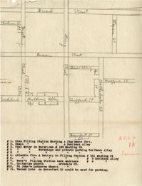
Map of area bounded by Market Street, Meeting Street, Horlbeck Street, and King Street.
Description:
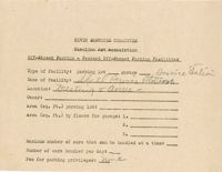
Off-street parking facilities survey filled out for Al--cida on 396 Meeting Street.
Description:
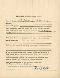
Church owned property questionnaire filled out for St. Phillip's Church.
Description:
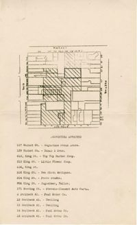
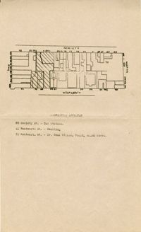
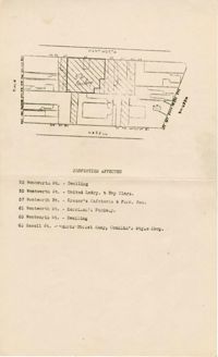
Map of area bounded by Society Street, Meeting Street, Wentworth Street, and King Street.
Description:
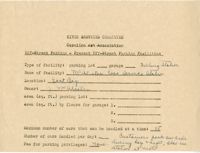
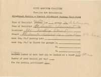
Off-street parking facilities survey filled out for Shell Service Station.
Description:
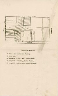
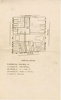
Map of area bounded by George Street, King Street, Burns Lane, and Meeting Street.
Description:
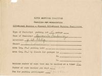
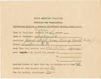
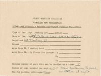
Off-street parking facilities survey filled out for Firestone Service Station.
Description:
Off-street parking facilities survey filled out for Taud M. Esso Station.
Description:
Off-street parking facilities survey filled out for Misereudino Motor Co.
Description:
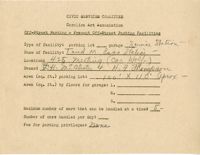
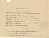
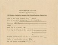
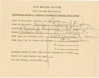
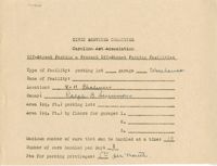
Off-street parking facilities survey filled out for Kennison's Parkway.
Description:
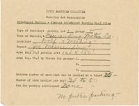
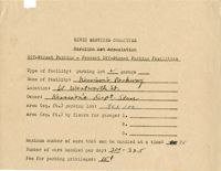
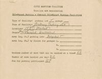
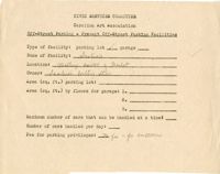
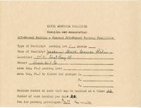
Off-street parking facilities survey filled out for Brown's Parkway.
Description:
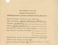
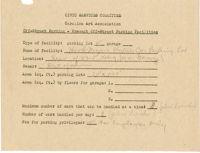
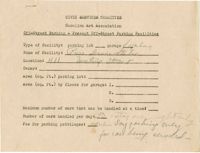
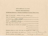
Off-street parking facilities survey filled out for Jack Krawcheck Parkway.
Description:
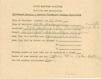
Off-street parking facilities survey filled out for Charleston Parking Lot on 80 Wentworth Street.
Description:
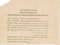
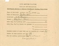
Off-street parking facilities survey filled out for George Street Parkway.
Date:
1944-10-11
Description:
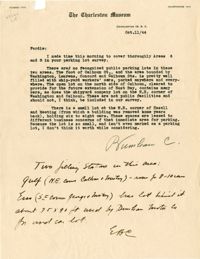
Letter to Ferdie regarding areas 6-8 of the off-street parking facilities survey (Oct. 11, 1944) and additional handwritten notes by EBC.
Date:
1944-06-26
Description:
Letter to B. M. Thompson from Robert N.S. Whitelaw (June 26, 1944) regarding his parking/traffic survey committee assignments.
Description:
Church owned property questionnaire filled out for Second Presbyterian Church.
Description:
Map of area bounded by Horlbeck Street, Meeting Street, and Queen Street.
Description:
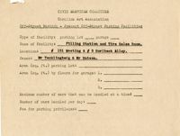
Off-street parking facilities survey filled out for Condon's Filling Station.
Description:
Off-street parking facilities survey filled out for Hood-Myers Electric Co.
Description:
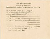
Off-street parking facilities survey filled out for Academy parking lot.
Description:
Off-street parking facilities survey filled out for Market and Hayne Service Station Inc.
Description:
Off-street parking facilities survey filled out for Big Star Store.
Description:
Off-street parking facilities survey filled out for Scobies Poultry Store.
Description:
Off-street parking facilities survey filled out for Pure Service Station.
Description:
Off-street parking facilities survey filled out for M.P. Headquarters with hand drawn map of parking on back.
Description:
Off-street parking facilities survey filled out for Condon's Parking lot.
Description:
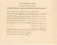
Off-street parking facilities survey filled out for Walling's Garage (Repairing).
Description:
Off-street parking facilities survey filled out for E. G. Harlston.
Date:
1944
Description:
Letter to A. W. Allison from Robert N.S. Whitelaw regarding a suggested schedule of Allison's committee meeting.
Description:
Church owned property questionnaire filled out for Citadel Square Baptist Church located on 328 Meeting Street.
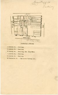
Description:
Map of area bounded by Wentworth Street, St. Philip Street, Liberty Street, and King Street.
Description:
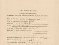
Off-street parking facilities survey filled out for Goldman's Service Station.
Description:
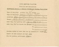
Off-street parking facilities survey filled out for Navy Shore Patrol.
Description:
Off-street parking facilities survey filled out for Southern Railroad.
Description:
Off-street parking facilities survey filled out for warehouse at 4-11 Chalmers Street.
Description:
Off-street parking facilities survey filled out for warehouses and garage on 113 Church Street.
Description:
Off-street parking facilities survey filled out for Jackson Street Service Station.
Description:
Off-street parking facilities survey filled out for a parking lot on 2-4 State Street.
Description:
Off-street parking facilities survey filled out for McAlister Esso Service Station.
Description:
Off-street parking facilities survey filled out for C.R. Batson's Esso Service Station.
Description:
Off-street parking facilities survey filled out for Argyle Hotel.
Description:
Off-street parking facilities survey filled out for Filling Station and Tire Sales Room.
Date:
1944-07-25
Description:
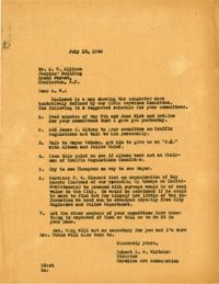
Letter to Rene Ravenel from Robert N.S. Whitelaw (July 25, 1944) regarding his parking/traffic survey committee assignments.
Description:
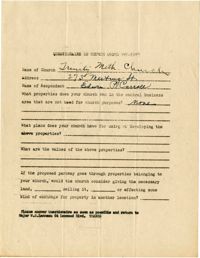
Church owned property questionnaire filled out for Trinity Methodist Church located on 273 Meeting Street.
Description:
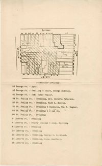
Map of area bounded by George Street, King Street, Liberty Street, and St. Philip Street.
Description:
Off-street parking facilities survey filled out for Francis Marion Hotel.
Description:
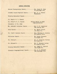
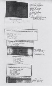
List of members of the Civic Services Committee Church Committee.
Description:
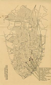
Map of the Charleston peninsula showing churches in congested areas.
Description:
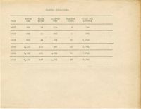
Table depicting the traffic violations from the year 1937-1942. The violations are broken down by race and gender.
Date:
1944-07-25
Description:
Letter to C. Bissell Jenkins from Robert N.S. Whitelaw (July 25, 1944) regarding his parking/traffic survey committee assignments.
Date:
1944-09
Description:
Summary of an interview done with James Altman by June S. Wing regarding parking and parking practices (Sept., 1944).
Date:
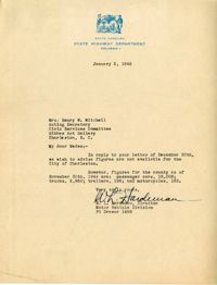
1945
Description:
Letter to the Civic Services Committee from W. L. Hardeman regarding Charleston county figures for passenger cars, trucks, trailers, and motorcycles.
Description:
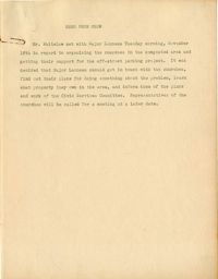
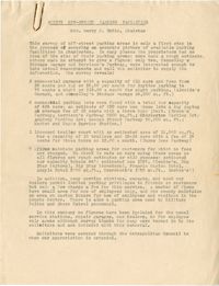
Memorandum from Robert N.S. Whitelaw regarding a meeting he had with Major Lanneau about organizing the support of churches in congested areas.
Description:
Assignment of individuals to various aspects of the parking and traffic surveys: cultural assets, fire insurance rates, inventory of City owned property in congested areas, inventory of off-street parking facilities, survey of land values, traffic regulations committee, traffic studies and parking practices, and values experience of business areas. Also included, a description of "value experience of business areas" committee.
Description:
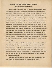
Summary of an interview done with Mrs. Kinloch and Mr. Grice regarding parking and traffic conditions between 1939 and 1943.
Description:
List of city owned property in congested traffic areas compiled by the committee on "Inventory of City Owned Property in Congested Areas."
Date:
1944-08-01
Description:
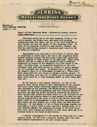
Report of C. Bissell Jenkins on fire insurance rates affected by present interior block conditions (August 1, 1944).
Description:
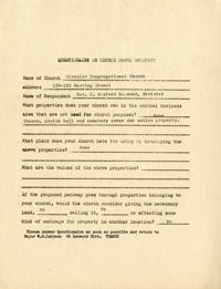
Church owned property questionnaire filled out for Circular Congregation Church on 138-150 Meeting Street.
Description:
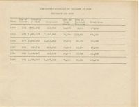
Table of Comparative Statement of Property at Risk Insurance and Loss for the years 1900, 1910, 1920, 1930, 1940, and 1942.
Description:
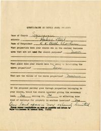
Church owned property questionnaire filled out for Synagogue on Hasell Street.
Description:
Results of the off-street parking facilities survey in Mrs. Harry M. Rubin's report.
Date:
1944-10-17
Description:
Resolutions made by the Board of Vestry and Wardens of St. John's Lutheran Church (Oct. 17, 1944).
Description:
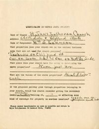
Church owned property questionnaire filled out for St. John's Lutheran Church.
Description:
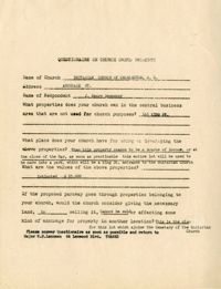
Church owned property questionnaire filled out for Unitarian Church of Charleston, SC.
Description:
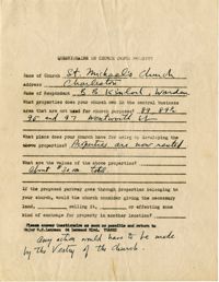
Church owned property questionnaire filled out for St. Michael's Church.
Description:
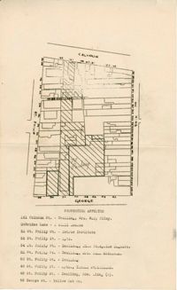
Map of area bounded by Calhoun Street, King Street, George Street, and St. Philip Street.
Description:
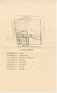
Map of area bounded by Wentworth Street, St. Philip Street, Beaufain Street, and King Street.
Description:
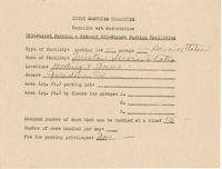
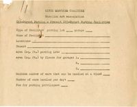
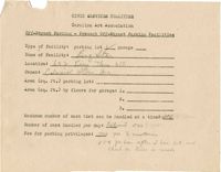
Blank off-street parking form for present off-street parking facilities attached to area list (List of areas 1-13).
Description:
Off-street parking facilities survey filled out for Marion Square (County Center).
Description:
Off-street parking facilities survey filled out for Joe Rutledge at 192 St. Philip Street.
Description:
Off-street parking facilities survey filled out for Fort Sumter Chevrolet Co.
Date:
1944-10-24
Description:
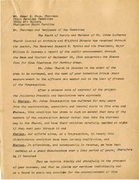
Letter to W. S. Lanneau from Robert N.S. Whitelaw regarding the resolutions of the Board of Vestry and Wardens of St. Johns Lutheran Church (Oct. 24, 1944).
Description:
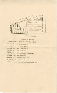
Map of area bounded by Wentworth Street, Meeting Street, Hasell Street, and King Street.
Description:
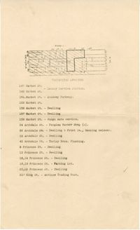
Map of area bounded by Archdale Street, Beaufain Street, King Street, and Market Street.
Description:
Map of area bounded by Market Street, King Street, Princess Street, and Archdale Street.
Description:
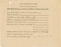
Off-street parking facilities survey filled out for Burn's Lane Parkway.
Description:
Off-street parking facilities survey filled out for Big Star.