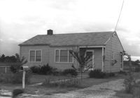
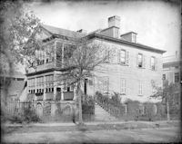
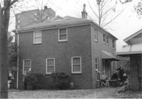
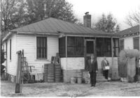
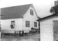
House on site affected by the construction of Interstate 26 (I-26). Surveyor notations on back of photo: "Dkt.: 10.471. Property owner: Andrew J. Hovanec. Tract: 154. Station: 5485+50 Lt. Date: Aug. 23, 1960. Proximity." [See collection description for explanation of surveyor notations.]
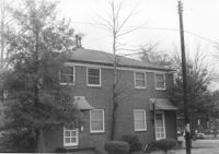
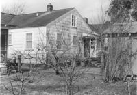
House (rear view) on site affected by the construction of Interstate 26 (I-26). Surveyor notations on back of photo: "Dkt.: 10.471. Property owner: Andrew J. Hovanec. Tract: 154. Station: 5485+50 Lt. Date: Aug. 23, 1960. Proximity." [See collection description for explanation of surveyor notations.]
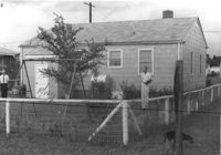
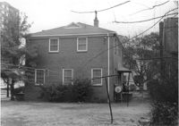
House (rear view) on site affected by the construction of Interstate 26 (I-26). Surveyor notations on back of photo: "Dkt.: 10.471. Property owner: Jacquelyne E. Kaylor. Tract: 156. Station: 5486+75 Lt. Date: Aug. 23, 1960. Proximity." [See collection description for explanation of surveyor notations.]
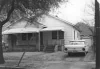
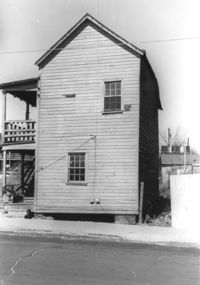
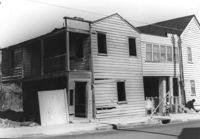
House (review view) on site affected by the construction of the Crosstown. Address: 76 Cooper Street. Surveyor notations on back of photo: "Dkt.: 10.518. Property owner: Lewis Rosen. Tract: 11. Station: 5965+10 CL Line 3, S.B. lane Route 17. Date: Mar. 6, 1963. In R/W - Bought. [See collection description for explanation of surveyor notations.]
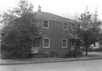
House on site affected by the construction of Interstate 26 (I-26). Surveyor notations on back of photo: "Dkt.: 10.471. Property owner: Jacquelyne E. Kaylor. Tract: 156. Station: 5486+75 Lt. Date: Aug. 23, 1960. Proximity." [See collection description for explanation of surveyor notations.]
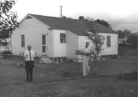
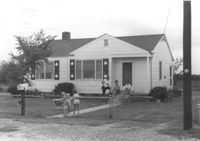
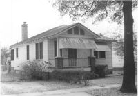
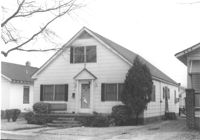
House on site affected by the construction of Interstate 26 (I-26). Address: 40 Enston Avenue [40 North Enston Avenue]. Surveyor notations on back of photo: "Dkt.: 10.503. Property owner: George Stamos, et al. Tract: 2. Station: 5891+35 Rt. Date: Feb. 19, 1963. In R/W - Bought." [See collection description for explanation of surveyor notations.]
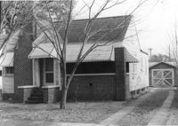
House (rear view) on site affected by the construction of Interstate 26 (I-26). Address: 40 Enston Avenue [40 North Enston Avenue[. Surveyor notations on back of photo: "Dkt.: 10.503. Property owner: George Stamos, et al. Tract: 2. Station: 5891+35 Rt. Date: Feb. 19, 1963. In R/W - Bought." [See collection description for explanation of surveyor notations.]
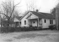
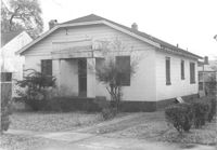
Dwelling (rear view) on site affected by the construction of Interstate 26 (I-26). Address: 39-43 Mount Pleasant Street. Surveyor notations on back of photo: "Dkt.: 10.503. Property owner: Joyce L. Darby, et al. Tract: 3. Station: 5891+00 Rt. Date: Feb. 19, 1963. Portion in R/W to be removed." [See collection description for explanation of surveyor notations.]
Dwelling on site affected by the construction of Interstate 26 (I-26). Address: 39-43 Mount Pleasant Street. Appears to be a duplex. Surveyor notations on back of photo: "Dkt.: 10.503. Property owner: Joyce L. Darby, et al. Tract: 3. Station: 5891+00 Rt. Date: Feb. 19, 1963. Portion in R/W to be removed." [See collection description for explanation of surveyor notations.]
Dwelling (rear view) on site affected by the construction of Interstate 26 (I-26). Address: 39-43 Mount Pleasant Street. Surveyor notations on back of photo: "Dkt.: 10.503. Property owner: Mary Ellen Long Way. Tract: 4. Station: 5891+80 Lt. Date: Feb. 19, 1963. In R/W - Bought." [See collection description for explanation of surveyor notations.]
Dwelling on site affected by the construction of Interstate 26 (I-26). Address: 39-43 Mount Pleasant Street. Appears to be a duplex. Surveyor notations on back of photo: "Dkt.: 10.503. Property owner: Mary Ellen Long Way. Tract: 4. Station: 5891+80 Lt. Date: Feb. 19, 1963. In R/W - Bought." [See collection description for explanation of surveyor notations.]
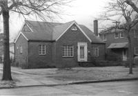
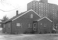
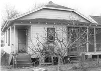
House on site affected by the construction of Interstate 26 (I-26). Address: 169 Laurel Avenue. Surveyor notations on back of photo: "Dkt.: 10.503. Property owner: Ernestine L. Captain. Tract: 5. Station: 5892+10 Rt. Date: Feb. 19, 1963. In R/W - Bought." [See collection description for explanation of surveyor notations.]
House (corner view, rear) on site affected by the construction of Interstate 26 (I-26).Address: 169 Laurel Avenue. Joseph Floyd Manor (Mount Pleasant Street and King Street) in background. Surveyor notations on back of photo: "Dkt.: 10.503. Property owner: Ernestine L. Captain. Tract: 5. Station: 5892+10 Rt. Date: Feb. 19, 1963. In R/W - Bought." [See collection description for explanation of surveyor notations.]
Backyard area and neighboring houses on site affected by the construction of Interstate 26 (I-26). Address: Laurel Avenue (?). Surveyor notations on back of photo: "Dkt.: 10.503. Property owner: Francis D. Guzzell. Tract: 7. Station: 5894+55 Rt. Date: Feb. 19, 1963. Proximity." [See collection description for explanation of surveyor notations.]
House on site affected by the construction of the Crosstown. Address: 76 Cooper Street. Surveyor notations on back of photo: "Dkt.: 10.518. Property owner: Lewis Rosen. Tract: 11. Station: 5965+10 CL Line 3, S.B. lane Route 17. Date: Mar. 6, 1963. In R/W - Bought. [See collection description for explanation of surveyor notations.]
House (rear view) on site affected by the construction of Interstate 26 (I-26). Waverly Novels, Tales of a Grandfather; being stories taken from Scottish history, 2nd series in 2 volumes, vol. I. 160 Laurel Avenue. Surveyor notations on back of photo: "Dkt.: 10.503. Property owner: Joseph A. Pippin. Tract: 8. Station: 5894+40 Rt. Date: Feb. 19, 1963. In R/W - Bought." [See collection description for explanation of surveyor notations.]
House on site affected by the construction of Interstate 26 (I-26). Address: 160 Laurel Avenue. Surveyor notations on back of photo: "Dkt.: 10.503. Property owner: Joseph A. Pippin. Tract: 8. Station: 5894+40 Rt. Date: Feb. 19, 1963. In R/W - Bought." [See collection description for explanation of surveyor notations.]
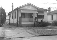
House on site affected by the construction of Interstate 26 (I-26). Address: 162 Laurel Avenue. Number 22 on porch column. Surveyor notations on back of photo: "Dkt.: 10.503. Property owner: David E. O'Brien. Tract: 9. Station: 5894+15 Rt. Date: Feb. 19, 1963. In R/W - Bought." [See collection description for explanation of surveyor notations.]
House (rear view) on site affected by the construction of Interstate 26 (I-26). Address: 162 Laurel Avenue. Surveyor notations on back of photo: "Dkt.: 10.503. Property owner: David E. O'Brien. Tract: 9. Station: 5894+15 Rt. Date: Feb. 19, 1963. In R/W - Bought." [See collection description for explanation of surveyor notations.]
House (rear view) on site affected by the construction of Interstate 26 (I-26). Address: 164 Laurel Avenue. Surveyor notations on back of photo: "Dkt.: 10.503. Property owner: J.W. Johnson, Jr. Tract: 10. Station: 5894+00 Rt. Date: Feb. 19, 1963. In R/W - Bought." [See collection description for explanation of surveyor notations.]
House on site affected by the construction of Interstate 26 (I-26). Address: 164 Laurel Avenue. Surveyor notations on back of photo: "Dkt.: 10.503. Property owner: J.W. Johnson, Jr. Tract: 10. Station: 5894+00 Rt. Date: Feb. 19, 1963. In R/W - Bought." [See collection description for explanation of surveyor notations.]
House on site affected by the construction of Interstate 26 (I-26). Address: 166-168 Laurel Avenue. Surveyor notations on back of photo: "Dkt.: 10.503. Property owner: J.W. Johnson, Jr. Tract: 10. Station: 5894+00 Rt. Date: Feb. 19, 1963. In R/W - Bought." [See collection description for explanation of surveyor notations.]
House (rear view) on site affected by the construction of Interstate 26 (I-26). Address: 166-168 Laurel Avenue. Surveyor notations on back of photo: "Dkt.: 10.503. Property owner: J.W. Johnson, Jr. Tract: 10. Station: 5894+00 Rt. Date: Feb. 19, 1963. In R/W - Bought." [See collection description for explanation of surveyor notations.]
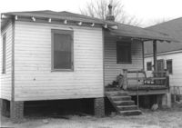
House (rear view) on site affected by the construction of Interstate 26 (I-26). Address: 170 Laurel Avenue. Surveyor notations on back of photo: "Dkt.: 10.503. Property owner: Eula Mae Ryan. Tract: 12. Station: 5893+40 Lt. Date: Feb. 19, 1963. In R/W - Bought." [See collection description for explanation of surveyor notations.]
House on site affected by the construction of Interstate 26 (I-26). Address: 170 Laurel Avenue. Number 28 on porch column. Surveyor notations on back of photo: "Dkt.: 10.503. Property owner: Eula Mae Ryan. Tract: 12. Station: 5893+40 Lt. Date: Feb. 19, 1963. In R/W - Bought." [See collection description for explanation of surveyor notations.]
Houses on site affected by the construction of the Crosstown. Address: 74½ Cooper Street [74 Cooper Street]. Surveyor notations on back of photo: "Dkt.: 10.518. Property owner: Beatrice Hayward. Tract: 12. Station: 5965+30 Rt. Line 3, S.B. lane of Route 17. Date: Mar. 6, 1963. In R/W - Bought. [See collection description for explanation of surveyor notations.]