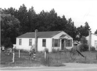
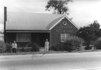
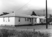
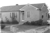
House on site affected by the construction of Interstate 26 (I-26). Surveyor notations on back of photo: "Dkt.: 10.471. Property owner: L.R. Watkins. Tract: 95. Station: 5378+90 Lt. Date: Aug. 23, 1960. In R/W - Bought." [See collection description for explanation of surveyor notations.]
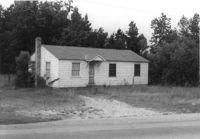
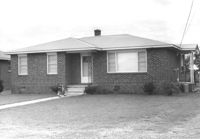
House on site affected by the construction of Interstate 26 (I-26). Surveyor notations on back of photo: "Dkt.: 10.471. Property owner: Isabella W. Meany. Tract: 98. Station: 5378+80 Rt. Date: Aug. 23, 1960. In R/W - Bought." [See collection description for explanation of surveyor notations.]
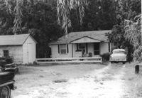
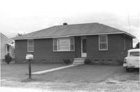
House on site affected by the construction of Interstate 26 (I-26). Surveyor notations on back of photo: "Dkt.: 10.471. Property owner: Eliz H. Riddle. Tract: 99. Station: 5378+20 Rt. Date: Aug. 23, 1960. In R/W - Bought." [See collection description for explanation of surveyor notations.]
House on site affected by the construction of Interstate 26 (I-26). Surveyor notations on back of photo: "Dkt.: 10.471. Property owner: C.D. Jones. Tract: 101. Station: 5377± Rt. Date: Aug. 23, 1960. Proximity." [See collection description for explanation of surveyor notations.]
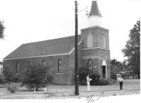
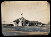
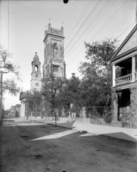
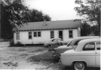
Mid Park Methodist Church, on site affected by the construction of Interstate 26 (I-26). Surveyor notations on back of photo: "Dkt.: 10.471. Property owner: Mid Park Meth. Church. Tract: 102. Station: 5376+50 Rt. Date: Aug. 23, 1960. Proximity." [See collection description for explanation of surveyor notations.]
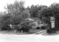
House, and Fuller's Grocery, on site affected by the construction of Interstate 26 (I-26). Surveyor notations on back of photo: "Dkt.: 10.471. Property owner: H.L. Fuller. Tract: 103. Station: 28+00 Lt. (Midland Park Road). Date: Aug. 23, 1960. Proximity." [See collection description for explanation of surveyor notations.]
Postcard. New Year commemorative, 1908 - illustration of winter scene accented by pine branches, pinecones, and flowers. Mailed from Chicago, Illinois.
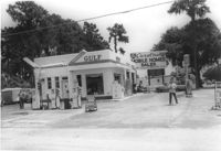
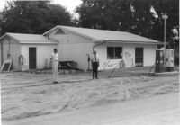
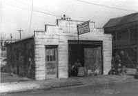
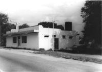
Gulf gas station, on site affected by the widening of State Road 13 (Remount Road). Surveyor notations on back of photo: "Dkt.: 10.562. Property owner: E.R. Gassman. Tract: 1. Date: Jul. 12, 1967." [See collection description for explanation of surveyor notations.]
Renken Boat Co, on site affected by the widening of Route 171 (Folly Road). Surveyor notations on back of photo: "Dkt.: 10.494. Property owner: Renken Finance Co. Tract: 19. Station: 157+00 Lt. Date: Mar. 21, 1962. Proximity. [See collection description for explanation of surveyor notations.]
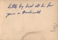
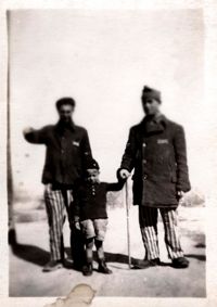
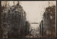
A black and white photograph taken at the Buchenwald Concentration Camp in Germany shortly after its liberation in April 1945. The photo is of a boy between two liberated inmates of Buchenwald.
Houses (review view) on site affected by the construction of the Crosstown. Address: 80 Cooper Street. Surveyor notations on back of photo: "Dkt.: 10.518. Property owner: Helen Phillips Brown. Tract: 9. Station: 38+95 Rt. N.B. lane Route 17. Date: Mar. 6, 1963. In R/W - Bought. [See collection description for explanation of surveyor notations.]
House on site affected by the construction of Interstate 26 (I-26). Surveyor notations on back of photo: "Dkt.: 10.471. Property owner: Noble M. Drennen. Tract: 104. Station: 5379+30 Lt. Date: Aug. 23, 1960. Proximity." [See collection description for explanation of surveyor notations.]
House on site affected by the construction of Interstate 26 (I-26). Building address number 22 (painted on mailbox). Surveyor notations on back of photo: "Dkt.: 10.471. Property owner: Eleanor L. O'Brien. Tract: 105. Station: 5379+50 Lt. Date: Aug. 23, 1960. Proximity." [See collection description for explanation of surveyor notations.]
House on site affected by the construction of Interstate 26 (I-26). Surveyor notations on back of photo: "Dkt.: 10.471. Property owner: Donald C. Drennen. Tract: 106. Station: 5380+00 Lt. Date: Aug. 23, 1960. Proximity." [See collection description for explanation of surveyor notations.]
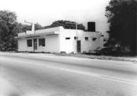
Gulf gas station on site affected by the construction of Interstate 26 (I-26). Surveyor notations on back of photo: "Dkt.: 10.471. Property owner: W.W. Holcombe. Tract: 109. Station: 5380+00 Lt. Date: Aug. 23, 1960. Proximity." [See collection description for explanation of surveyor notations.]
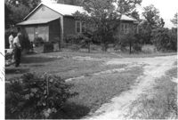
House on site affected by the construction of Interstate 26 (I-26). Surveyor notations on back of photo: "Dkt.: 10.471. Property owner: Annie C. Craven. Tract: 116. Station: 5396+10 Rt. Date: Aug. 23, 1960. In R/W - Bought." [See collection description for explanation of surveyor notations.]
House on site affected by the construction of Interstate 26 (I-26). Surveyor notations on back of photo: "Dkt.: 10.471. Property owner: Annie C. Craven. Tract: 116. Station: 5396+10 Rt. Date: Aug. 23, 1960. In R/W - Bought." [See collection description for explanation of surveyor notations.]
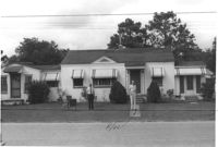
House on site affected by the construction of Interstate 26 (I-26). Surveyor notations on back of photo: "Dkt.: 10.471. Property owner: M.A. Carson. Tract: 119. Station: 18+50 Rt. (Eagle Dr.) Date: Aug. 23, 1960. Proximity." [See collection description for explanation of surveyor notations.]
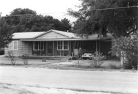
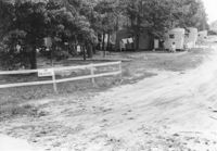
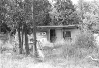
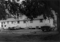
Mobile homes and lot, on site affected by the construction of Interstate 26 (I-26). Surveyor notations on back of photo: "Dkt.: 10.471. Property owner: Mary R. Walker. Tract: 131. Station: 5475+00 Lt. Date: Aug. 23, 1960. Proximity." [See collection description for explanation of surveyor notations.]
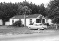
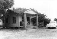
House on site affected by the construction of Interstate 26 (I-26). Surveyor notations on back of photo: "Dkt.: 10.471. Property owner: Pauline P. Badger. Tract: 132. Station: 5476+00 Lt. Date: Aug. 23, 1960. In R/W - Bought." [See collection description for explanation of surveyor notations.]
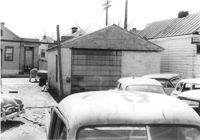
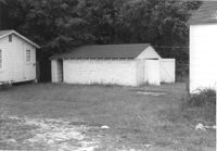
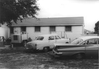
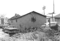
Outbuildings behind house on site affected by the construction of Interstate 26 (I-26). Surveyor notations on back of photo: "Dkt.: 10.471. Property owner: Pauline P. Badger. Tract: 132. Station: 5476+00 Lt. Date: Aug. 23, 1960. In R/W - Bought." [See collection description for explanation of surveyor notations.]
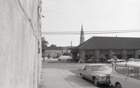
Building, on site affected by the construction of the Crosstown. Address: 80 Cooper Street. Front facade has stepped parapet. Surveyor notations on back of photo: "Dkt.: 10.518. Property owner: Helen Phillips Brown. Tract: 9. Station: 38+95 Rt. N.B. lane Route 17. Date: Mar. 6, 1963. In R/W - Bought. [See collection description for explanation of surveyor notations.]
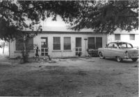
Outbuilding (small house) behind house on site affected by the construction of Interstate 26 (I-26). Surveyor notations on back of photo: "Dkt.: 10.471. Property owner: Pauline P. Badger. Tract: 132. Station: 5476+50 Lt. Date: Aug. 23, 1960. In R/W - Bought." [See collection description for explanation of surveyor notations.]
House on site affected by the construction of Interstate 26 (I-26). Surveyor notations on back of photo: "Dkt.: 10.471. Property owner: W.A. Buero. Tract: 133. Station: 5476+80 Lt. Date: Aug. 23, 1960. In R/W - Bought." [See collection description for explanation of surveyor notations.]
House on site affected by the construction of Interstate 26 (I-26). Surveyor notations on back of photo: "Dkt.: 10.471. Property owner: Sivley J. McKay. Tract: 134. Station: 5477+10 Lt. Date: Aug. 23, 1960. In R/W - Bought." [See collection description for explanation of surveyor notations.]
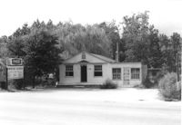
House on site affected by the construction of Interstate 26 (I-26). Sign for Owen's Dry Cleaners at left of photograph. Surveyor notations on back of photo: "Dkt.: 10.471. Property owner: Harry M. Charpia, Jr. Tract: 135. Station: 5377+50 Lt. Date: Aug. 23, 1960. In R/W - Bought." [See collection description for explanation of surveyor notations.]
House on site affected by the construction of Interstate 26 (I-26). Surveyor notations on back of photo: "Dkt.: 10.471. Property owner: Harry M. Charpia, Jr. Tract: 135. Station: 5377+50 Lt. Date: Aug. 23, 1960. In R/W - Bought." [See collection description for explanation of surveyor notations.]
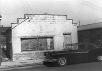
Owen's Dry Cleaners, on site affected by the construction of Interstate 26 (I-26). Building address number 2160. Surveyor notations on back of photo: "Dkt.: 10.471. Property owner: Willa W.S. Owens. Tract: 136. Station: 5477+80 Lt. Date: Aug. 23, 1960. In R/W - Bought." [See collection description for explanation of surveyor notations.]
Small dilapidated building on site affected by the construction of Interstate 26 (I-26). Behind building in previous photograph (I-26 Photo 115). Surveyor notations on back of photo: "Dkt.: 10.471. Property owner: Willa W.S. Owens. Tract: 136. Station: 5477+80 Lt. Date: Aug. 23, 1960. In R/W - Bought." [See collection description for explanation of surveyor notations.]
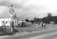
Sinclair gasoline station on site affected by the construction of Interstate 26 (I-26). Surveyor notations on back of photo: "Dkt.: 10.471. Property owner: Sinclair Refining Co. Tract: 138. Station: 1+50 Rt. (Remount Road). Date: Aug. 23, 1960. Proximity." [See collection description for explanation of surveyor notations.]
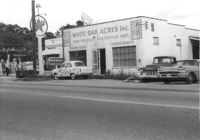
White Oak Acres, Inc. (butcher shop) on site affected by the construction of Interstate 26 (I-26). Neighboring Texaco gas station in background. Surveyor notations on back of photo: "Dkt.: 10.471. Property owner: R.H. Bowers. Tract: 139. Station: 1+30 Lt. (Remount Road). Date: Aug. 23, 1960. Proximity." [See collection description for explanation of surveyor notations.]
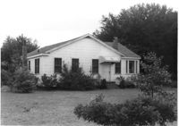
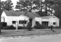
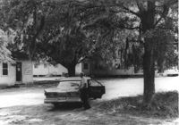
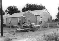
House on site affected by the construction of Interstate 26 (I-26). Surveyor notations on back of photo: "Dkt.: 10.471. Property owner: Mildred G. Bowers. Tract: 141. Station: 3+00 Lt. (Remount Road). Date: Aug. 23, 1960. Proximity." [See collection description for explanation of surveyor notations.]
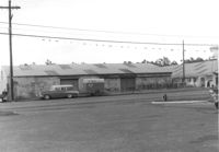
Building -- Simmons Garage -- on site affected by the construction of the Crosstown. Address: 76 Cooper Street or 78 Cooper Street. Front facade has stepped parapet. Surveyor notations on back of photo: "Dkt.: 10.518. Property owner: Helen Phillips Brown. Tract: 10. Station: 39+30 Rt. North Bound Survey of Route 17. Date: Mar. 6, 1963. In R/W - Bought. [See collection description for explanation of surveyor notations.]
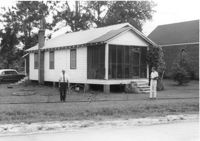
House on site affected by the construction of Interstate 26 (I-26). Surveyor notations on back of photo: "Dkt.: 10.471. Property owner: Palmetto Flower Corp. Tract: 143. Station: 5479+35 Lt. Date: Aug. 23, 1960. Building No. 1. In R/W - Bought." [See collection description for explanation of surveyor notations.]
Dwelling on site affected by the construction of Interstate 26 (I-26). Appears to be a triplex or apartment house. Surveyor notations on back of photo: "Dkt.: 10.471. Property owner: Palmetto Flower Corp. Tract: 143. Station: 5480+00 Lt. Date: Aug. 23, 1960. Building No. 2. In R/W - Bought." [See collection description for explanation of surveyor notations.]
Dwelling on site affected by the construction of Interstate 26 (I-26). Surveyor notations on back of photo: "Dkt.: 10.471. Property owner: Palmetto Flower Corp. Tract: 143. Station: 5480+20 Lt. Date: Aug. 23, 1960. Building No. 3. In R/W - Bought." [See collection description for explanation of surveyor notations.]
Dwelling on site affected by the construction of Interstate 26 (I-26). Appears to be a duplex. Surveyor notations on back of photo: "Dkt.: 10.471. Property owner: Palmetto Flower Corp. Tract: 143. Station: 5480+30 Lt. Date: Aug. 23, 1960. Building No. 4. In R/W - Bought." [See collection description for explanation of surveyor notations.]
Dwelling on site affected by the construction of Interstate 26 (I-26). Appears to be apartments. Surveyor notations on back of photo: "Dkt.: 10.471. Property owner: Palmetto Flower Corp. Tract: 143. Station: 5480+20 Lt. Date: Aug. 23, 1960. Building No. 5. In R/W - Bought." [See collection description for explanation of surveyor notations.]
Dwelling on site affected by the construction of Interstate 26 (I-26). Appears to be a duplex. Surveyor notations on back of photo: "Dkt.: 10.471. Property owner: Palmetto Flower Corp. Tract: 143. Station: 5479+50 Lt. Date: Aug. 23, 1960. Building No. 6. In R/W - Bought." [See collection description for explanation of surveyor notations.]
Dwelling on site affected by the construction of Interstate 26 (I-26). Building address number Apt. 10. Surveyor notations on back of photo: "Dkt.: 10.471. Property owner: Palmetto Flower Corp. Tract: 143. Station: 5479+50 Lt. Date: Aug. 23, 1960. Building No. 7. In R/W - Bought." [See collection description for explanation of surveyor notations.]
Dwellings on site affected by the construction of Interstate 26 (I-26). See previous seven photographs. Lane's Dry Cleaners and Laundry at left of photo. Surveyor notations on back of photo: "Dkt.: 10.471. Property owner: Palmetto Flower Corp. Tract: 143. Station: 5480+00 Lt. Date: Aug. 23, 1960. Panoramic view. In R/W - Bought." [See collection description for explanation of surveyor notations.]
Portaro's Pizza Spaghetti Restaurant on site affected by the construction of Interstate 26 (I-26). Surveyor notations on back of photo: "Dkt.: 10.471. Property owner: Marko Moskas, et al. Tract: 144. Station: 5478+15 Lt. Date: Aug. 23, 1960. In R/W - Bought." [See collection description for explanation of surveyor notations.]
Portaro's Pizza Spaghetti Restaurant on site affected by the construction of Interstate 26 (I-26). Surveyor notations on back of photo: "Dkt.: 10.471. Property owner: Marko Moskas, et al. Tract: 144. Station: 5478+15 Lt. Date: Aug. 23, 1960. In R/W - Bought." [See collection description for explanation of surveyor notations.]
Rear view of building -- Simmons Garage -- on site affected by the construction of the Crosstown. Address: 76 Cooper Street or 78 Cooper Street. Surveyor notations on back of photo: "Dkt.: 10.518. Property owner: Helen Phillips Brown. Tract: 10. Station: 39+30 Rt. North Bound Route 17 Lane. Date: Mar. 6, 1963. In R/W - Bought. [See collection description for explanation of surveyor notations.]
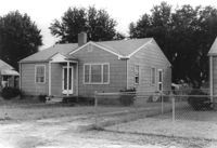
House on site affected by the construction of Interstate 26 (I-26). Surveyor notations on back of photo: "Dkt.: 10.471. Property owner: T.M. Evans. Tract: 145. Station: 5481+10 Lt. Date: Aug. 23, 1960. In R/W - Bought." [See collection description for explanation of surveyor notations.]
House on site affected by the construction of Interstate 26 (I-26). Surveyor notations on back of photo: "Dkt.: 10.471. Property owner: W.R. Wren. Tract: 148. Station: 5482+00 Lt. Date: Aug. 23, 1960. In R/W - Bought." [See collection description for explanation of surveyor notations.]
House on site affected by the construction of Interstate 26 (I-26). Surveyor notations on back of photo: "Dkt.: 10.471. Property owner: L. Pellatiro. Tract: 149. Station: 5282+60 Lt. Date: Aug. 23, 1960. In R/W - Bought." [See collection description for explanation of surveyor notations.]
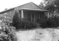
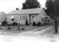
House on site affected by the construction of Interstate 26 (I-26). Building address number 13. Surveyor notations on back of photo: "Dkt.: 10.471. Property owner: N.B. Charles. Tract: 150. Station: 5483+20 Lt. Date: Aug. 23, 1960. In R/W - Bought." [See collection description for explanation of surveyor notations.]
House on site affected by the construction of Interstate 26 (I-26). Surveyor notations on back of photo: "Dkt.: 10.471. Property owner: Laura M. McGorty. Tract: 151. Station: 5483+80 Lt. Date: Aug. 23, 1960. In R/W - Bought." [See collection description for explanation of surveyor notations.]
House on site affected by the construction of Interstate 26 (I-26). Surveyor notations on back of photo: "Dkt.: 10.471. Property owner: T.M. Evans. Tract: 152. Station: 5484+40 Lt. Date: Aug. 23, 1960. In R/W - Bought." [See collection description for explanation of surveyor notations.]
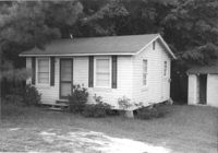
House on site affected by the construction of Interstate 26 (I-26). Surveyor notations on back of photo: "Dkt.: 10.471. Property owner: T.M. Evans. Tract: 153. Station: 5485+00 Lt. Date: Aug. 23, 1960. In R/W - Bought." [See collection description for explanation of surveyor notations.]