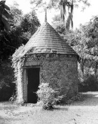
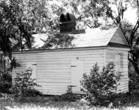
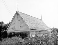
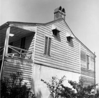
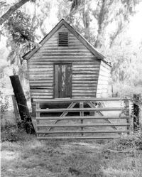
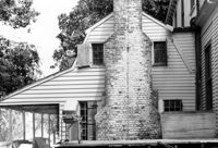
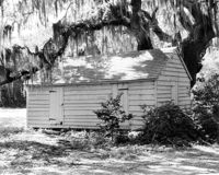
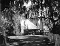
Boone Hall Plantation, Oak Avenue. Smoke House - View of NW (Front and Side) elevation. Mount Pleasant, S.C.;10" x 8" B/W photo. Box 10, Folder 2-2-5. One copy.
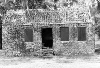
Boone Hall Plantation, Oak Avenue. Slave Cabin - View of North (Front) elevation. Mount Pleasant, S.C.;6.5" x 10" B/W photo. Box 10, Folder 2-2-5. One copy.
Arnoldus Vander Horst House (Kiawah House), Mansion Court. Detail View of Entrance. South (Front) elevation. Kiawah Island, S.C.;10" x 8" B/W photo. Box 12, Folder 2-6-1. One copy.
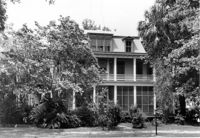
Arnoldus Vander Horst House (Kiawah House), Mansion Court. View of North (Rear) elevation. Kiawah Island, S.C.;8" x 10" B/W photo. Box 12, Folder 2-6-1. One copy.
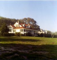
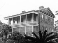
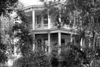
Arnoldus Vander Horst House (Kiawah House), Mansion Court. View of South (Front) elevation. Kiawah Island, S.C.;6.5" x 10" B/W photo. Box 12, Folder 2-6-1. One copy.
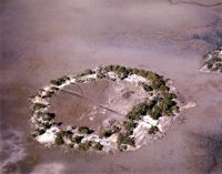
Quarter House Fort & Tavern Site, Success Street (between Meeting Street Road and Rivers Avenue). View of SE elevation. North Charleston, S.C.;6.5" x 10" B/W photo. Box 5, Folder 2-1-10. One copy.
Quarter House Fort & Tavern Site, Success Street (between Meeting Street Road and Rivers Avenue). View of SE elevation. North Charleston, S.C.;6.5" x 10" B/W photo. Box 5, Folder 2-1-10. One copy.
McLeod Plantation, 325 Country Club Drive. Laundry Building - View of NW (Front and Side) elevation. Charleston, S.C.;8" x 10" B/W photo. Box 12, Folder 2-4-5. One copy.
Secessionville Manor (Secessionville Plantation), Battallion Drive. View of South (Front) elevation. Charleston, S.C.;3" x 3" Color photo. Box 12, Folder 2-4-6. One copy.
Rockville Historic District - Ladson Webb House (Exchange Plantation House), Sea Island Yacht Club Road. View of North (Front) elevation. Wadmalaw Island, S.C.;6.5" x 10" B/W photo. Box 17, Folder 2-14-8. One copy.
Rockville Historic District - Ladson Webb House (Exchange Plantation House), Sea Island Yacht Club Road. View of South (Rear) elevation. Wadmalaw Island, S.C.;6.5" x 10" B/W photo. Box 17, Folder 2-14-8. One copy.
Bleak Hall Plantation, S.C. Hwy. 174. Tractor Shed - View of SW (Side and Rear) elevation. Edisto Island, S.C.;8" x 10" B/W photo. Box 10, Folder 2-3-2. One copy.
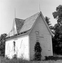
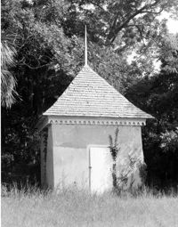
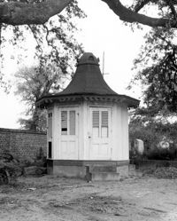
Bleak Hall Plantation, S.C. Hwy. 174. Ice House - View of NE (Front and Side) elevation. Edisto Island, S.C.;8" x 8" B/W photo. Box 10, Folder 2-3-2. One copy.
Bleak Hall Plantation, S.C. Hwy. 174. Ice House - View of NE (Front and Side) elevation. Edisto Island, S.C.;8" x 10" B/W photo. Box 10, Folder 2-3-2. One copy.
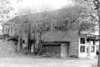
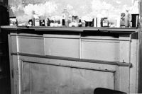
Firetag's Store (Mappus' Store, Six Mile Store), Success Street (between Meeting Street Road and Rivers Avenue). View of SW (Rear and Side) elevation. North Charleston, S.C.;6.5" x 10" B/W photo. Box 5, Folder 2-1-7. One copy.
Firetag's Store (Mappus' Store, Six Mile Store), Success Street (between Meeting Street Road and Rivers Avenue). View of West (Side) elevation. North Charleston, S.C.;6.5" x 10" B/W photo. Box 5, Folder 2-1-7. One copy.
Firetag's Store (Mappus' Store, Six Mile Store), Success Street (between Meeting Street Road and Rivers Avenue). View of East (Side) elevation. North Charleston, S.C.;6.5" x 10" B/W photo. Box 5, Folder 2-1-7. One copy.
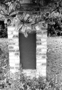
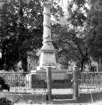
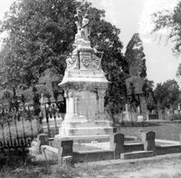
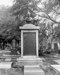
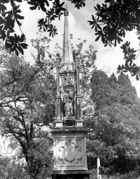
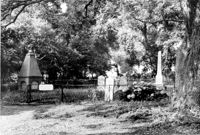
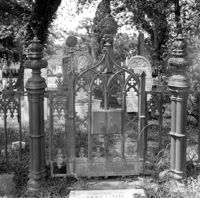
Magnolia Cemetery, Huguenin Avenue and Algonquin Road. Monument of Emma Heyward Haskell. Charleston, S.C.;8" x 8" B/W photo. Box 5, Folder 2-1-3. One copy.
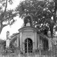
Magnolia Cemetery, Huguenin Avenue and Algonquin Road. Gibbes Mausoleum. View of Front elevation. Charleston, S.C.;8" x 8" B/W photo. Box 5, Folder 2-1-3. One copy.
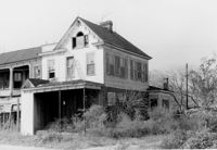
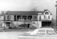
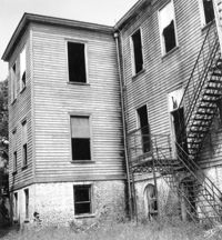
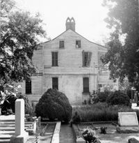
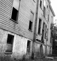
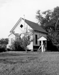
Shaw Community Center, 22 Mary Street. Main Building - View of SE (Side and Rear) elevation. Charleston, S.C. (NOTE: Structure demolished in 1974);8.25" x 7.5" B/W photo. Box 6, Folder 2-1-13. One copy.
Shaw Community Center, 22 Mary Street. Main Building - View of SW (Rear and Side) elevation. Charleston, S.C. (NOTE: Structure demolished in 1974);8.25" x 7.5" B/W photo. Box 6, Folder 2-1-13. One copy.
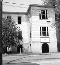
Shaw Community Center, 22 Mary Street. Main Building - View of North (Front) elevation. Charleston, S.C. (NOTE: Structure demolished in 1974);8.25" x 7.5" B/W photo. Box 6, Folder 2-1-13. One copy.
St. James Bethel Church (Zion Chapel, St. James Bethel AME Church), 5305 Maybank Highway. View of NW (Front and Side) elevation. Wadmalaw Island, S.C.;10" x 8" B/W photo. Box 17, Folder 2-14-25. One copy.
Boone Hall Plantation, Oak Avenue. Old Commissary - View of SW (Front and Side) elevation. Mount Pleasant, S.C.;6.5" x 10" B/W photo. Box 10, Folder 2-2-5. One copy.
Shaw Community Center, 22 Mary Street. Main Building - View of South (Rear) elevation. Charleston, S.C. (NOTE: Structure demolished in 1974);8.25" x 7.5" B/W photo. Box 6, Folder 2-1-13. One copy.
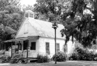
Shaw Community Center, 22 Mary Street. Coach House - View of NW elevation. Charleston, S.C. (NOTE: Structure demolished in 1974);8.25" x 7.5" B/W photo. Box 6, Folder 2-1-13. One copy.
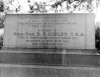
Magnolia Cemetery, Huguenin Avenue and Algonquin Road. Tombstone of R.S. Ripley. View of South elevation. Charleston, S.C.;8" x 10" B/W photo. Box 5, Folder 2-1-3. One copy.
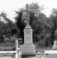
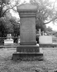
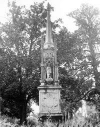
Magnolia Cemetery, Huguenin Avenue and Algonquin Road. Tombstone of William Gilmore Simms. Charleston, S.C.;10" x 8" B/W photo. Box 5, Folder 2-1-3. One copy.
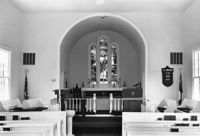
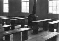
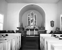
Christ Church Episcopal - Adams Run, State Highway 174. View of Interior. West (Front) elevation. Hollywood, S.C.;6.5" x 10" B/W photo. Box 16, Folder 2-11-12. Three copies.
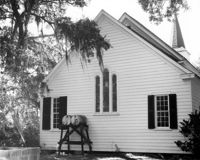
Christ Church Episcopal - Adams Run, State Highway 174. View of North (Side) elevation. Hollywood, S.C.;6.5" x 10" B/W photo. Box 16, Folder 2-11-12. Three copies.
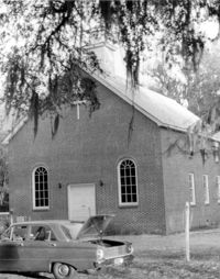
Christ Church Episcopal - Adams Run, State Highway 174. View of West (Front) elevation. Hollywood, S.C.;10" x 6.5" B/W photo. Box 16, Folder 2-11-12. Three copies.
Christ Church Episcopal - Adams Run, State Highway 174. View of South (Side) elevation. Hollywood, S.C.;8" x 10" B/W photo. Box 16, Folder 2-11-12. One copy.
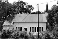
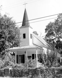
Mount Pleasant Presbyterian Church, 302 Hibben Street (NE corner of Hibben and Church Street). View of SE (Front) elevation. Mount Pleasant, S.C.;6.5" x 10" (and 8" x 10") B/W photo. Box 13, Folder 2-8-6. Two copies.
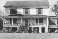
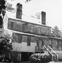
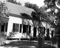
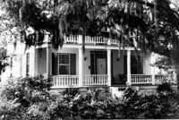
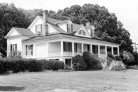
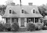
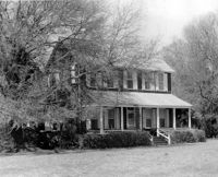
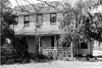
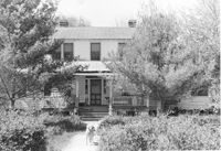
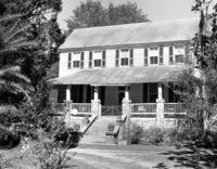
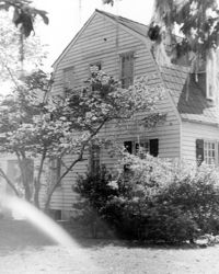
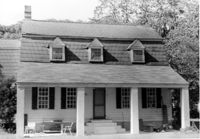
Captain Peter Lewis House, 206 Live Oak Drive. View of South (Front) elevation. Mount Pleasant, S.C.;6.5" x 10" B/W photo. Box 13, Folder 2-8-12. One copy.
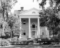
Captain Peter Lewis House, 206 Live Oak Drive. View of South (Front) elevation. Mount Pleasant, S.C.;8" x 10" B/W photo. Box 13, Folder 2-8-12. Three copies.
Quarter House Fort & Tavern Site, Success Street (between Meeting Street Road and Rivers Avenue). Detail View of Tavern Entrance Post and Historical Marker. Front and Side elevation. North Charleston, S.C.;10" x 6.5" B/W photo. Box 5, Folder 2-1-10. One copy.
Quarter House Fort & Tavern Site, Success Street (between Meeting Street Road and Rivers Avenue). Detail View of Tavern Entrance Post and Historical Marker. Front elevation. North Charleston, S.C.;10" x 6.5" B/W photo. Box 5, Folder 2-1-10. One copy.
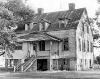
Peter's Point Plantation, off S.C. Hwy 174 on County Road 764 (Peters Point Road). View of SE (Rear) elevation. Edisto Island, S.C.;6.5" x 10" B/W photo. Box 11, Folder 2-3-17. One copy.
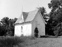
Bleak Hall Plantation, S.C. Hwy. 174. Ice House - View of East (Front) elevation. Edisto Island, S.C.;8" x 10" B/W photo. Box 10, Folder 2-3-2. Two copies.
Boone Hall Plantation, Oak Avenue. Slave Cabins - General View of NW (Front and Side) elevation. Mount Pleasant, S.C.;6.5" x 10" B/W photo. Box 10, Folder 2-2-5. One copy.
Magnolia Cemetery, Huguenin Avenue and Algonquin Road. Monument of Colonel William Washington. View of South elevation. Charleston, S.C.;8" x 8" B/W photo. Box 5, Folder 2-1-3. One copy.
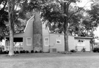
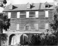
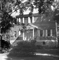
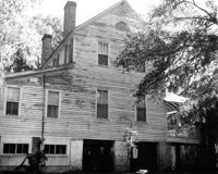
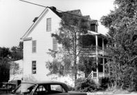
Stiles Point Plantation (Stiles-Hinson-Thompson House), 940 Paul Revere Drive. View of South (Rear) elevation. Charleston S.C.;6.5" x 10" B/W photo. Box 12, Folder 2-4-7. One copy.
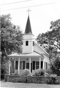
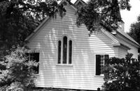
St. Andrews Episcopal Church (Mount Pleasant), 440 Whilden Street. View of East (Side) elevation. Mount Pleasant, S.C.;6.5" x 10" B/W photo. Box 13, Folder 2-8-18. Three copies.
Christ Church Episcopal - Adams Run, State Highway 174. View of West (Front) elevation. Hollywood, S.C.;10" x 8" B/W photo. Box 16, Folder 2-11-12. One copy.
Boone Hall Plantation, Oak Avenue. Rat Proof Barn - View of South (Front) elevation. Mount Pleasant, S.C.;10" x 8" B/W photo. Box 10, Folder 2-2-5. One copy.
Peter's Point Plantation, off S.C. Hwy 174 on County Road 764 (Peters Point Road). View of NW (Front) elevation. Edisto Island, S.C.;6.5" x 10" B/W photo. Box 11, Folder 2-3-17. One copy.
Magnolia Cemetery, Huguenin Avenue and Algonquin Road. Monument of Sarah F., Charles F., and Elbert P. Jones. View of South elevation. Charleston, S.C.;10" x 8" B/W photo. Box 5, Folder 2-1-3. One copy.
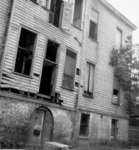
Stiles Point Plantation (Stiles-Hinson-Thompson House), 940 Paul Revere Drive. View of East (Side) elevation - Rear addition only. Charleston S.C.;6.5" x 10" B/W photo. Box 12, Folder 2-4-7. One copy.
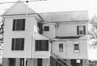
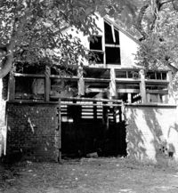
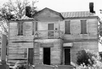
Stiles Point Plantation (Stiles-Hinson-Thompson House), 940 Paul Revere Drive. View of NE (Front and Side) elevation. Charleston S.C.;6.5" x 10" B/W photo. Box 12, Folder 2-4-7. One copy.
Stiles Point Plantation (Stiles-Hinson-Thompson House), 940 Paul Revere Drive. View of North (Front) elevation. Charleston S.C.;6.5" x 10" B/W photo. Box 12, Folder 2-4-7. One copy.
McLeod Plantation, 325 Country Club Drive. Main House - View of South (Front) elevation. Charleston, S.C.;6.5" x 10" B/W photo. Box 12, Folder 2-4-5. One copy.
McLeod Plantation, 325 Country Club Drive. Main House - View of East (Side) elevation. Charleston, S.C.;8" x 10" B/W photo. Box 12, Folder 2-4-5. One copy.
McLeod Plantation, 325 Country Club Drive. Kitchen Building - View of NW (Front and Side) elevation. Charleston, S.C.;8" x 10" B/W photo. Box 12, Folder 2-4-5. One copy.
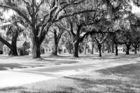
McLeod Plantation, 325 Country Club Drive. Slave Cabins Avenue - View of West (Side) elevation. Charleston, S.C.;8" x 10" B/W photo. Box 12, Folder 2-4-5. One copy.
Shaw Community Center, 22 Mary Street. Main Building - View of South (Rear) elevation, looking West. Charleston, S.C. (NOTE: Structure demolished in 1974);8.25" x 7.5" B/W photo. Box 6, Folder 2-1-13. One copy.
Christ Church Episcopal - Adams Run, State Highway 174. View of East (Rear) elevation. Hollywood, S.C.;6.5" x 10" B/W photo. Box 16, Folder 2-11-12. Three copies.
Magnolia Cemetery, Huguenin Avenue and Algonquin Road. Tombstone of Birt family. View of Front elevation. NOTE: Print has superimposed second image. Charleston, S.C.;8" x 8" B/W photo. Box 5, Folder 2-1-3. Two copies.
Magnolia Cemetery, Huguenin Avenue and Algonquin Road. Monument of William Ashmead Courtenay. View of Front elevation. Charleston, S.C.;10" x 8" B/W photo. Box 5, Folder 2-1-3. One copy.
Christ Church Episcopal - Adams Run, State Highway 174. View of Interior. West (Front) elevation. Hollywood, S.C.;8" x 10" B/W photo. Box 16, Folder 2-11-12. One copy.
Christ Church Episcopal - Adams Run, State Highway 174. View of East (Rear) elevation. Hollywood, S.C.;8" x 10" B/W photo. Box 16, Folder 2-11-12. One copy.
Bleak Hall Plantation, S.C. Hwy. 174. Smoke House - View of SW (Front) elevation. Edisto Island, S.C.;10" x 8" B/W photo. Box 10, Folder 2-3-2. One copy.
Magnolia Cemetery, Huguenin Avenue and Algonquin Road. Monument of Sarah F., Charles F., and Elbert P. Jones. View of North elevation. Charleston, S.C.;10" x 8" B/W photo. Box 5, Folder 2-1-3. One copy.
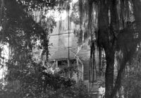
Rockville Historic District - Rockville Presbyterian Church, 2479 Sea Island Yacht Club Road. View of South (Front) elevation. Wadmalaw Island, S.C.;8" x 10" B/W photo. Box 17, Folder 2-14-10. One copy.
Rockville Historic District - John F. Sosnowski House, Grace Chapel Road. View of SW (Front and Side) elevation. Wadmalaw Island, S.C.;8" x 10" B/W photo. Box 17, Folder 2-14-21. One copy.
Rockville Historic District - John F. Sosnowski House, Grace Chapel Road. View of South (Front) elevation. Wadmalaw Island, S.C.;8" x 10" B/W photo. Box 17, Folder 2-14-21. One copy.
Rockville Historic District - Fanny Wilson House, Grace Chapel Road. View of South (Front) elevation. Wadmalaw Island, S.C.;6.5" x 10" B/W photo. Box 17, Folder 2-14-20. One copy.
Rockville Historic District - Cornelia J. Whaley House, Grace Chapel Road. View of South (Front) elevation. Wadmalaw Island, S.C.;6.5" x 10" B/W photo. Box 17, Folder 2-14-19. One copy.
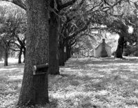
Magnolia Cemetery, Huguenin Avenue and Algonquin Road. Chapel - View of Side and Rear elevation. Charleston, S.C.;10" x 8" B/W photo. Box 5, Folder 2-1-3. One copy.
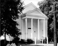
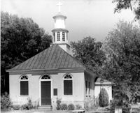
Christ Church (Christ Episcopal Church), 2304 U.S. Highway 17. View of North (Front) elevation. Mount Pleasant, S.C.;8" x 10" B/W photo. Box 10, Folder 2-2-6. One copy.
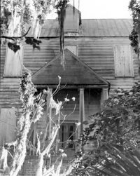
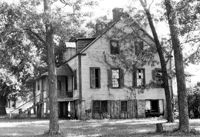
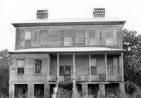
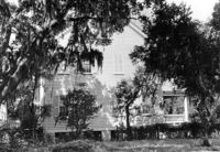
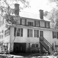
Oakland Plantation (Youghall Plantation), 1164 Porcher Bluff Road. Main House - View of SW (Side and Rear) elevation. Mount Pleasant, S.C.;10" x 8" B/W photo. Box 10, Folder 2-2-10. One copy.
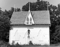
Oakland Plantation (Youghall Plantation), 1164 Porcher Bluff Road. Kitchen House - View of NE (Front) elevation. Mount Pleasant, S.C.;6.5" x 10" B/W photo. Box 10, Folder 2-2-10. One copy.
Oakland Plantation (Youghall Plantation), 1164 Porcher Bluff Road. Main House - View of North (Front) elevation. Mount Pleasant, S.C.;6.5" x 10" B/W photo. Box 10, Folder 2-2-10. One copy.
Oakland Plantation (Youghall Plantation), 1164 Porcher Bluff Road. Main House - View of South (Rear) elevation. Mount Pleasant, S.C.;6.5" x 10" B/W photo. Box 10, Folder 2-2-10. One copy.
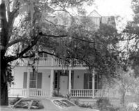
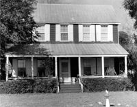
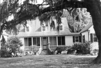
Captain Peter Lewis House, 206 Live Oak Drive. View of West (Side) elevation. Mount Pleasant, S.C.;6.5" x 10" B/W photo. Box 13, Folder 2-8-12. Two copies.