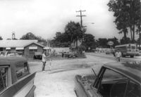
Site affected by the widening of State Road 13 (Remount Road). Surveyor notations on back of photo: "Dkt.: 10.562. Property owner: F.L. Parks, Jr. Tract: 3. Date: Jul. 12, 1967." [See collection description for explanation of surveyor notations.]
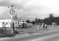
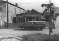
Sinclair gasoline station on site affected by the construction of Interstate 26 (I-26). Surveyor notations on back of photo: "Dkt.: 10.471. Property owner: Sinclair Refining Co. Tract: 138. Station: 1+50 Rt. (Remount Road). Date: Aug. 23, 1960. Proximity." [See collection description for explanation of surveyor notations.]
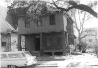
House (freedman's cottage) on site affected by the construction of the Crosstown. Address: 26 Kracke Street. Surveyor notations on back of photo: "Dkt.: 10.524. Property owner: Julia Brown. Tract: 68. Station: 77+55 Lt. Date: Oct. 14, 1964. Proximity." [See collection description for explanation of surveyor notations.]
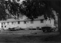
Dwelling on site affected by the construction of Interstate 26 (I-26). Appears to be a triplex or apartment house. Surveyor notations on back of photo: "Dkt.: 10.471. Property owner: Palmetto Flower Corp. Tract: 143. Station: 5480+00 Lt. Date: Aug. 23, 1960. Building No. 2. In R/W - Bought." [See collection description for explanation of surveyor notations.]
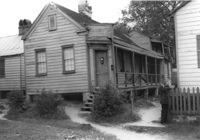
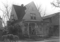
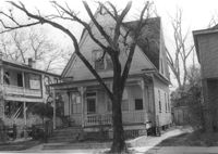
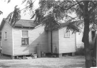
House on site affected by the construction of the Crosstown. Address: 121 Sheppard Street. Surveyor notations on back of photo: "Dkt.: 10.524. Property owner: Erline B. Wertan. Tract: 138. Station: 17+05 Rt. N.B. lane. Date: Dec. 2, 1964. In R/W - Bought." [See collection description for explanation of surveyor notations.]
House on site affected by the construction of the Crosstown. Address: 121 Sheppard Street. Surveyor notations on back of photo: "Dkt.: 10.524. Property owner: Erline B. Wertan. Tract: 138. Station: 17+05 Rt. N.B. lane. Date: Dec. 2, 1964. In R/W - Bought." [See collection description for explanation of surveyor notations.]
Dwelling on site affected by the construction of Interstate 26 (I-26). Appears to be a duplex. Surveyor notations on back of photo: "Dkt.: 10.471. Property owner: Palmetto Flower Corp. Tract: 143. Station: 5480+30 Lt. Date: Aug. 23, 1960. Building No. 4. In R/W - Bought." [See collection description for explanation of surveyor notations.]
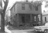
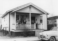
House on site affected by the construction of the Crosstown. Address: 119 Sheppard Street. Surveyor notations on back of photo: "Dkt.: 10.524. Property owner: Scott M. Boyle. Tract: 139. Station: 17+45 Rt. N.B. lane. Date: Dec. 2, 1964. In R/W - Bought." [See collection description for explanation of surveyor notations.]
House on site affected by the construction of the Crosstown. Address: 119 Sheppard Street. Surveyor notations on back of photo: "Dkt.: 10.524. Property owner: Scott M. Boyle. Tract: 139. Station: 17+45 Rt. N.B. lane. Date: Dec. 2, 1964. In R/W - Bought." [See collection description for explanation of surveyor notations.]
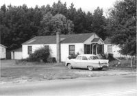
House on site affected by the construction of Interstate 26 (I-26). Surveyor notations on back of photo: "Dkt.: 10.471. Property owner: Pauline P. Badger. Tract: 132. Station: 5476+00 Lt. Date: Aug. 23, 1960. In R/W - Bought." [See collection description for explanation of surveyor notations.]
House (freedman's cottage) on site affected by the construction of Interstate 26 (I-26). Building address number 2003(?). Surveyor notations on back of photo: "Dkt.: 10.490. Property owner: L. Bradley. Tract: 39. Station: 5797+70 on CL Line 'G'. Date: September 11, 1962. In R/W - Bought." [See collection description for explanation of surveyor notations.]
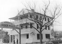
Cole Lumber Company, presumably main office building, on site affected by the construction of Interstate 26 (I-26). Sign arches over the entrance: C. Ed Cole Lumber Mills. Address from 1961 City Directory: 293 Huger Street. Address from 1951 Sanborn Map: 17 Huger Street. Surveyor notations on back of photo: "Dkt.: 10.517. Property owner: Charles E. Cole Lumber Co. Tract 1. Station: 5937+70 Lt. Date: February 21, 1963." [See collection description for explanation of surveyor notations.]
House (freedman's cottage) (rear view) on site affected by the construction of Interstate 26 (I-26). Surveyor notations on back of photo: "Dkt.: 10.490. Property owner: Janie Simmons. Tract: 41. Station: 5798+30 on CL Line 'G'. Date: September 12, 1962. In R/W - Bought." [See collection description for explanation of surveyor notations.]
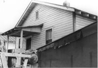
House (rear view) on site affected by the construction of Interstate 26 (I-26). Address: 48 Sheppard Street. Surveyor notations on back of photo: "Dkt.: 10.517. Property owner: Michael Criley. Tract: 74. Station: 5959+75 CL - Line 3. Date: March 5, 1963. In R/W - Bought." [See collection description for explanation of surveyor notations.]
House (rear view) on site affected by the construction of Interstate 26 (I-26). [Building address number 1989.] Surveyor notations on back of photo: "Dkt.: 10.490. Property owner: John Hamilton. Tract: 33. Station: 5795+35 on CL Line 'A'. Date: September 11, 1962. In R/W - Bought." [See collection description for explanation of surveyor notations.]
House on site affected by the construction of Interstate 26 (I-26). Address: 46 Sheppard Street. Surveyor notations on back of photo: "Dkt.: 10.517. Property owner: Mary Wolfe Hennersby. Tract: 73. Station: 5960+15 CL - Line 3. Date: March 5, 1963. In R/W - Bought." [See collection description for explanation of surveyor notations.]