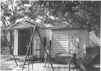
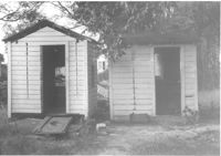
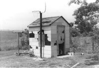
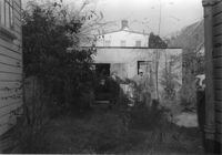
Two sheds and swing set, with standing girl, on site affected by the construction of Interstate 26 (I-26). Address: 2124 Weaver Avenue. Surveyor notations on back of photo: "Dkt.: 10.490. Property owner: Harry L. Rumph, Jr. Tract: 188. Station: 30' Lt. Sta. 5886-55. Date: May 15, 1962. In R/W - Bought." [See collection description for explanation of surveyor notations.]
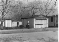
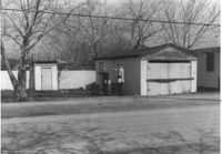
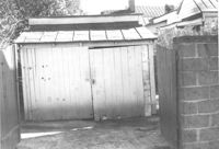
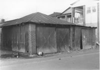
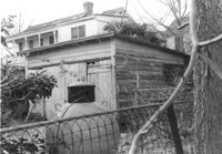
Garage and shed on site affected by the construction of Interstate 26 (I-26). Surveyor notations on back of photo: "Dkt.: 10.490. Property owner: Mostester Brown [Mostester Brown?]. Tract: 87-C. Station: 5825+45 Rt. Date: March 22, 1962. In R/W - Bought." [See collection description for explanation of surveyor notations.]
Garage and shed on site affected by the construction of Interstate 26 (I-26). Surveyor notations on back of photo: "Dkt.: 10.490. Property owner: Mostester Brown [Montester Brown?]. Tract: 87-C. Station: 5825+45 Rt. [Undated.] In R/W - Bought." [See collection description for explanation of surveyor notations.]
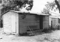
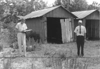
Shed (railroad building) on site affected by the construction of Interstate 26 (I-26). Address: 19½ Poinsett Street (rear). Surveyor notations on back of photo: "Dkt.: 10.503. Property owner: S.A.L.R.R. Tract: 105. Station: 5924+25 Rt. Date: Feb. 20, 1963." [See collection description for explanation of surveyor notations.]
Shed on site affected by the construction of Interstate 26 (I-26). Address: 27 Indian Street. (1951 Sanborn map indicates the address is 17 Indian Street.) Surveyor notations on back of photo: "Dkt.: 10.503. Property owner: Eloise Williams. Tract: 76. Station: 5913+90 Lt. Date: Feb. 20, 1963. In R/W - Bought." [See collection description for explanation of surveyor notations.]
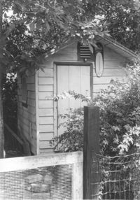
Shed on site affected by the construction of Interstate 26 (I-26). Address: 2130 Montford Avenue. Surveyor notations on back of photo: "Dkt.: 10.490. Property owner: Rosa Lee Knight. Tract: 173. Station: 5884+00 Lt. Date: May 15, 1962. In R/W - Bought." [See collection description for explanation of surveyor notations.]
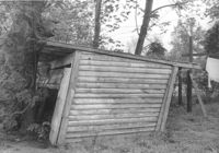
Shed on site affected by the construction of Interstate 26 (I-26). Surveyor notations on back of photo: "Dkt.: 10.480. Property owner: C.H. & Elise V. Meidburg. Tract: 249. Station: 5705+80 Lt. Date: May 31, 1961. In R/W - Bought." [See collection description for explanation of surveyor notations.]
Two sheds on site affected by the construction of Interstate 26 (I-26).Address: 2124 Weaver Avenue. Surveyor notations on back of photo: "Dkt.: 10.490. Property owner: Harry L. Rumph, Jr. Tract: 188. Station: 5887±00 Lt. Date: August 29, 1962. In R/W - Bought." [See collection description for explanation of surveyor notations.]
Shed on site affected by the construction of Interstate 26 (I-26). Surveyor notations on back of photo: "Dkt.: 10.490. Property owner: Leah D. Governor. Tract: 58. Station: 5800+60 Rt. Line 'G'. Date: September 12, 1962. In R/W - Bought." [See collection description for explanation of surveyor notations.]
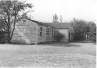
Shed or garage on site affected by the construction of Interstate 26 (I-26). Address: 85 Sheppard Street. Surveyor notations on back of photo: "Dkt.: 10.517. Property owner: Douglas E. Holmes. Tract: 86. Station: 26+40 Lt. Northbound Lane Route 17. Date: March 5, 1963. In R/W - Bought." [See collection description for explanation of surveyor notations.]
Storage shed on site affected by the construction of the Crosstown. Address182 Nassau Street. Surveyor notations on back of photo: "Dkt.: 10.518. Property owner: Euphrasia E. Lewis. Tract: 35. Station: 42+40 CL S.B. lane Route 17. Date: Mar. 6, 1963. In R/W - Bought. [See collection description for explanation of surveyor notations.]
Storage shed on site affected by the construction of Interstate 26 (I-26). Possibly on Rivers Avenue. Surveyor notations on back of photo: "Dkt.: 10.486. Property owner: Ida K. Hill. Tract: 37. Station: 12+30 Lt. (Line D). Date: May 30, 1961. In R/W - Bought." [See collection description for explanation of surveyor notations.]
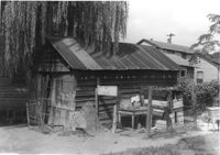
Sheds behind house on site affected by the widening of U.S. Route 17. Presumably located in Mount Pleasant or vicinity. Surveyor notations on back of photo: "Dkt.: 10.597. Property owner: Julia B. Simmons. Tract: 54. Station: 301±30 Lt. Date: Sept. 17, 1968." [See collection description for explanation of surveyor notations.]
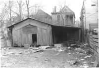
Garage and/or storage building on site affected by the construction of Interstate 26 (I-26).Address: 1317 King Street. Presumably part of the Rose Garden Tourist Court; see I-26 Photo 1467. Surveyor notations on back of photo: "Dkt.: 10.490. Property owner: The Long Corporation. Tract: 200. Station: 5889+45 Lt. Date: September 11, 1962. In R/W - Bought." [See collection description for explanation of surveyor notations.]
Small shed on site affected by the construction of Interstate 26 (I-26). Surveyor notations on back of photo: "Dkt.: 10.480. Property owner: Harold W. Cone. Tract: 285. Station: 5734+10 Lt. (Line B). Date: May 30, 1961. In R/W - Bought." [See collection description for explanation of surveyor notations.]
Shed or garage on site affected by the construction of Interstate 26 (I-26). Address: within the range of 20-32 Brigade Street. Surveyor notations on back of photo: "Dkt.: 10.503. Property owner: Gussie Feldman, et al.. Tract: 41. Station: 5903+92 Lt. (in Brigade St. R/W). Date: Feb. 19, 1963. In R/W - Bought." [See collection description for explanation of surveyor notations.]
Shed on site affected by the construction of Interstate 26 (I-26). Surveyor notations on back of photo: "Dkt.: 10.480. Property owner: Ruth I. Kirby. Tract: 236. Station: 5699+30 Lt. Date: May 2, 1961. In R/W - Bought." [See collection description for explanation of surveyor notations.]
Shed on site affected by the construction of the Crosstown. Address: 118 Sheppard Street. Surveyor notations on back of photo: "Dkt.: 10.524. Property owner: John H. Jenkins. Tract: 143. Station: 18+60 Lt. S.B. lane. Date: Dec. 2, 1964. Outside R/W." [See collection description for explanation of surveyor notations.]
Shed on site affected by the construction of the Crosstown. Address: 116 Sheppard Street. Surveyor notations on back of photo: "Dkt.: 10.524. Property owner: Margaret Oree. Tract: 144. Station: 18+95 Lt. S.B. lane. Date: Dec. 2, 1964. Outside R/W." [See collection description for explanation of surveyor notations.]
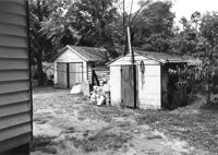
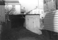
Sheds in backyard of house, on site affected by the construction of Interstate 26 (I-26). Address: 96 Sheppard Street. Surveyor notations on back of photo: "Dkt.: 10.517. Property owner: Celia McFadden. Tract: 102. 23+10 Rt. Southbound Lane Route 17. Date: March 5, 1963. In R/W - Bought." [See collection description for explanation of surveyor notations.]