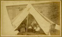
Caption: 'Cook's Earthquake Views of Charleston and Vicinity. Taken after the 31st of August, 1886. No.100, a family tent.' Image of an African-American nanny with three children.
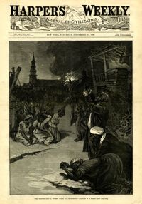
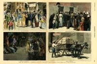
[Color image.] Main caption: 'After the Earthquake at Charleston.--drawn by W.A. Rogers and W.P. Snyder from sketches by Frederic Remington and A.J. Gustin.--[see page 610.]' Caption upper left: 'Open air preaching.' Caption upper right: 'Subsistence Committee.' Caption lower left: 'Negro prayer-meeting.' Caption lower right: 'Relief committee.' [full date September 18, 1886.]
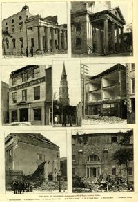
Caption: 'The Ruins Of Charleston.--photographed by W.E. Wilson, Savannah, Georgia. 1. The Guard House. 2. St. Michael's Church. 3. News and Courier Office. 4. St. Philip's Church. 5. No.27 Broad Street. 6. Hibernian Hall. 7. The Medical College.'
Caption: 'Cook's Earthquake Views of Charleston and Vicinity. Taken after the 31st of August, 1886. No.66, _____ Alston, East Battery.' Charleston city directory for 1886 shows various members of the Alston family at 21 East Battery.
Caption: 'Charleston Earthquake. Photographs by Dr. E.P. Howland, taken on his visit to Charleston and the earthquake region of Ten Mile Hill and Summervile. Over 150 Photographs were taken. House of Mrs. Snowden, President of Confederate Home.'
Caption: 'Cook's Earthquake Views of Charleston and Vicinity. Taken after the 31st of August, 1886. No.61, Mrs. B.D. Lazarus, Hasel [sic] St.' Charleston city directory for 1886 shows Mrs. B.D. Lazarus at 64 Hassell Street.
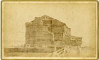
Caption: ' Cook's Earthquake Views of Charleston and Vicinity. Series No.2. No.164, Storehouse of Bennett's Mill.' Note on the catalog card show storehouse located at East end of Wentworth Street.
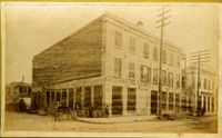
Caption: 'Cook's Earthquake Views of Charleston and Vicinity. Taken after the 31st of August, 1886. No.136, Meeting Street, cor. [of] Market.' Henry Steitz Produce is pictured. Charleston City directory for 1886 lists Henry Steitz, Fruits & Produce, at 113-115 Market Street.
Caption: 'Cook's Earthquake Views of Charleston and Vicinity. Taken after the 31st of August, 1886. No.115, Corner [of] Market and Anson Streets.' Sign on building reads: 'Ship & Family Groceries.' Written on front, at bottom: 'Charleston Earthquake view - cor. Market and Anson sts.'
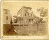
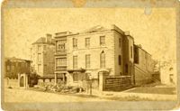
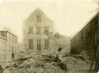
Charleston Earthquake scene. Written on reverse: 'East Battery, just below Atlantic Street. Edmonston [sic] House, later the Charles Alston residence. Now (1947) the residence of J.J. Pringle Smith. Old Holmes house on left. Earthquake of 1886 - Charleston, S.C.'
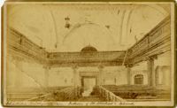
Caption: 'Cook's Earthquake Views of Charleston and Vicinity taken after the 31st of August, 1886. No.2, St. Michael's Church, Interior.' Handwritten along bottom: 'Charleston Earthquake scene - interior of St. Michael's Church.' Very similar to MK 4133.
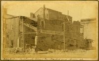
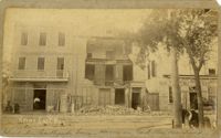
Charleston Earthquake scene. Possibly from Cook's Earthquake views, No.31, Tenement houses on East Bay. Written on front, at bottom: 'Charleston Earthquake scene - house on East Bay near Tradd.' Sign on building at left, reads: 'Ship & Family Groceries' known to be at the corner of East Bay and Queen. Sign on building at right, reads: '65' and possibly 'Sahlmann.' 1886 Charleston city directory lists L. Sahlmann, Hay & Grain, at 83 East Bay.

![[Elliott Street]](https://iiif.library.cofc.edu/iiif/2/50708/full/200,/0/default.jpg)