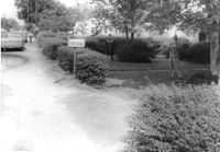
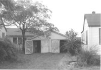
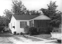
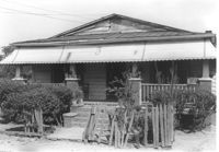
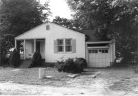
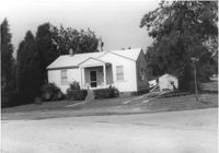
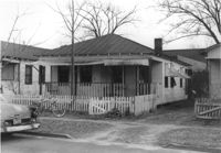
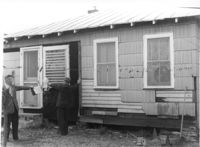
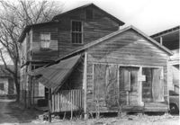
House on site affected by the widening of State Road 13 (Remount Road). 1552 Remount Road. Surveyor notations on back of photo: "Dkt.: 10.562. Property owner: Robert W. Kimbel. Tract: 60. Date: Jul. 19, 1967." [See collection description for explanation of surveyor notations.]
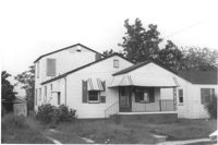
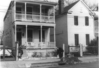
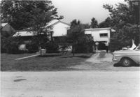
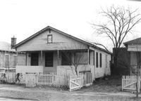
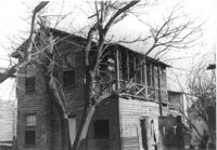
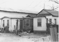
Houses on site affected by the widening of State Road 13 (Remount Road). Surveyor notations on back of photo: "Dkt.: 10.562. Property owner: James R. Robinson, Estate. Tract: 41. Date: Jul. 19, 1967." [See collection description for explanation of surveyor notations.]
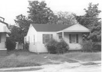
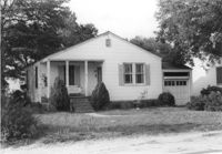
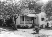
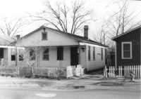
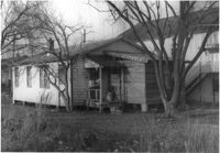
House on site affected by the widening of State Road 13 (Remount Road). Surveyor notations on back of photo: "Dkt.: 10.562. Property owner: Olivia Fleisher Estate. Tract: 38. Date: Jul. 19, 1967." [See collection description for explanation of surveyor notations.]
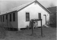
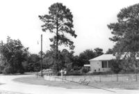
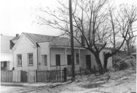
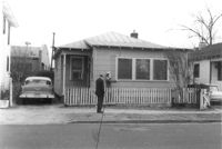
House on site affected by the widening of State Road 13 (Remount Road). Surveyor notations on back of photo: "Dkt.: 10.562. Property owner: Mrs. J.L. McFadyen. Tract: 69. Date: Jul. 19, 1967." [See collection description for explanation of surveyor notations.]
Garage and house at corner of Rutledge Avenue and Courtland Avenue, on site affected by the construction of Interstate 26 (I-26). Address: 1336 Rutledge Avenue. Surveyor notations on back of photo: "Dkt.: 10.490. Property owner: Annie E. Kirby. Tract: 158. Station: 5881+90 Rt. Date: August 29, 1962. In R/W - Bought." [See collection description for explanation of surveyor notations.]
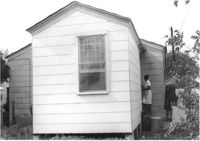
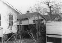
House (rear view) on site affected by the construction of Interstate 26 (I-26). Address: 2133 Weaver Avenue. Swing set in foreground with boy on swing. Surveyor notations on back of photo: "Dkt.: 10.490. Property owner: Arthur P. Jones. Tract: 199. Station: 5889+35 Rt. Date: May 15, 1962. In R/W - Bought." [See collection description for explanation of surveyor notations.]
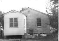
House (rear view) on site affected by the construction of Interstate 26 (I-26). Address: 2117 Weaver Avenue. See also I-26 Photos 1444-1445. Surveyor notations on back of photo: "Dkt.: 10.490. Property owner: Mrs. Lucretia Nowak. Tract: 191. Station: 5888+85 Lt. Date: May 15, 1962. In R/W - Bought." [See collection description for explanation of surveyor notations.]
House (rear view) on site affected by the construction of Interstate 26 (I-26). Address: 2122 Weaver Avenue. Surveyor notations on back of photo: "Dkt.: 10.490. Property owner: Olar C. Verdier [Ola C. Verdier]. Tract: 189. Station: 35' Lt. Sta. 5887+45. Date: May 15, 1962. In R/W - Bought." [See collection description for explanation of surveyor notations.]
House (rear view) on site affected by the construction of Interstate 26 (I-26). Address: 2119 Weaver Avenue. Surveyor notations on back of photo: "Dkt.: 10.490. Property owner: Marion Butler, et al. Tract: 192. Station: 5888+50 on CL. Date: May 15, 1962. In R/W - Bought." [See collection description for explanation of surveyor notations.]
House on site affected by the construction of Interstate 26 (I-26). Address: 2124 Weaver Avenue. Surveyor notations on back of photo: "Dkt.: 10.490. Property owner: Harry L. Rumph, Jr. Tract: 188. Station: 5887+20 on CL. Date: May 15, 1962. In R/W - Bought." [See collection description for explanation of surveyor notations.]
House on site affected by the construction of Interstate 26 (I-26). Address: 2124 Weaver Avenue. Surveyor notations on back of photo: "Dkt.: 10.490. Property owner: Harry L. Rumph, Jr. Tract: 188. Station: 5887±00 Lt. Date: August 29, 1962. In R/W - Bought." [See collection description for explanation of surveyor notations.]
House on site affected by the construction of Interstate 26 (I-26). Address: 2126 Weaver Avenue. Surveyor notations on back of photo: "Dkt.: 10.490. Property owner: J.L. Duffy. Tract: 187. Station: 5887±00 Rt. Date: August 29, 1962. In R/W - Bought." [See collection description for explanation of surveyor notations.]
House (rear view) on site affected by the construction of Interstate 26 (I-26). [Building address number 2209. 2209 Delano.] Surveyor notations on back of photo: "Dkt.: 10.490. Property owner: Dantzler H. Gardner, Est. Tract: 81. Station: 5824+00 Lt. Date: March 22, 1962. In R/W - Bought." [See collection description for explanation of surveyor notations.]
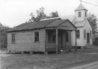
House associated with Francis Brown Methodist Church, on site affected by the construction of Interstate 26 (I-26). Surveyor notations on back of photo: "Dkt.: 10.490. Property owner: Francis Brown Meth. Church. Tract: 52. Station: 5800+20 Lt. Line 'F'. Date: September 12, 1962. Proximity to rear." [See collection description for explanation of surveyor notations.]
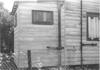
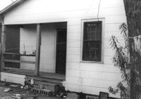
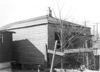
Exterior wall of house on site affected by the construction of Interstate 26 (I-26). Surveyor notations on back of photo: "Dkt.: 10.490. Property owner: William Parineau, et al. Tract: 54. Station: 5800+80 Lt. Line 'F'. Date: September 12, 1962. In R/W - Bought." [See collection description for explanation of surveyor notations.]
House on site affected by the construction of Interstate 26 (I-26). Surveyor notations on back of photo: "Dkt.: 10.490. Property owner: Lillian Ferguson. Tract: 43. Station: 5799+00 Rt. Line 'G.' Date: September 12, 1962. In R/W - Bought." [See collection description for explanation of surveyor notations.]
House on site affected by the construction of Interstate 26 (I-26). Surveyor notations on back of photo: "Dkt.: 10.490. Property owner: Nathaniel Phoenix. Tract: 46. Station: 5800+00 Rt. Line 'G'. Date: September 11, 1962. In R/W - Bought." [See collection description for explanation of surveyor notations.]
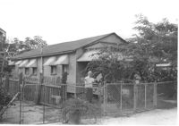
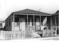
House on Coming Street near Sheppard Street, on site affected by the construction of Interstate 26 (I-26). Address: 276 Coming Street (L) and its neighbor, 274 Coming Street (R). Surveyor notations on back of photo: "Dkt.: 10.517. Property owner: William B. Hogan. Tract: 100. Station: 22+00 Rt. Northbound Lane Route 17. Date: March 5, 1963. Men on R/W (fence)." [See collection description for explanation of surveyor notations.]
House (rear view) on site affected by the construction of Interstate 26 (I-26). Address: 141 Cooper Street. (1951 Sanborn map indicates the address is 81 Cooper Street.) Surveyor notations on back of photo: "Dkt.: 10.517. Property owner: John D. Bendt Jr. Tract: 68. Station: 5958+70 Rt. - Line 4. Date: March 5, 1963. In R/W - Bought." [See collection description for explanation of surveyor notations.]
House (rear view) on site affected by the construction of Interstate 26 (I-26). Address: 143 Cooper Street. (1951 Sanborn map indicates the address is 93 Cooper Street) Surveyor notations on back of photo: "Dkt.: 10.517. Property owner: Annie L. Spell. Tract: 67. Station: 5958+80 Lt. - Line 3. Date: March 5, 1963. In R/W - Bought." [See collection description for explanation of surveyor notations.]
House on site affected by the construction of Interstate 26 (I-26). Address: 143 Cooper Street. (1951 Sanborn map indicates the address is 93 Cooper Street.) Surveyor notations on back of photo: "Dkt.: 10.517. Property owner: Annie L. Spell. Tract: 67. Station: 5958+80 Lt. - Line 3. Date: March 5, 1963. In R/W - Bought." [See collection description for explanation of surveyor notations.]
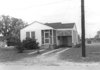
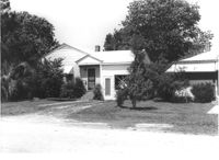
House on Dorchester Road, on site affected by the construction of Interstate 26 (I-26). Building address number 7. Surveyor notations on back of photo: "Dkt.: 10.480. Property owner: Fred M. Skipper. Tract: 179. Station: 132+90 Rt. (Route 642) [Dorchester Road]. Date: May 30, 1961. In R/W - Bought." [See collection description for explanation of surveyor notations.]
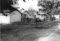
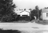
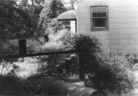
House on site affected by the construction of Interstate 26 (I-26). Partially obscured by trees. Garage (2-story) at end of driveway. Surveyor notations on back of photo: "Dkt.: 10.480. Property owner: Eugene J. Poteat. Tract: 201. Station: 5689+50 Lt. Date: May 31, 1961. In R/W - Bought." [See collection description for explanation of surveyor notations.]
House on Dorchester Road, on site affected by the construction of Interstate 26 (I-26). Building address number 7. Surveyor notations on back of photo: "Dkt.: 10.480. Property owner: Fred M. Skipper. Tract: 179. Station: 132+90 Rt. (Route 642) [Dorchester Road]. Date: May 30, 1961. In R/W - Bought." [See collection description for explanation of surveyor notations.]
House at curve in road, on site affected by the construction of Interstate 26 (I-26). Surveyor notations on back of photo: "Dkt.: 10.480. Property owner: Mrs. Hazel McSherley Barton. Tract: 185. Station: 5684+65± Rt. (Line D). Date: May 31, 1961. Damage to fence and loss of pine tree." [See collection description for explanation of surveyor notations.]
House on corner of Harvey Avenue, on site affected by the construction of Interstate 26 (I-26). Street sign for Harvey Ave. at right. Surveyor notations on back of photo: "Dkt.: 10.480. Property owner: Renkin Finance Co. Tract: 188. Station: 5686+00 Lt. Date: May 31, 1961. In R/W - Bought." [See collection description for explanation of surveyor notations.]
House on Dorchester Road, on site affected by the construction of Interstate 26 (I-26). Surveyor notations on back of photo: "Dkt.: 10.480. Property owner: Mrs. Margaret H. Patterson. Tract: 181. Station: 134+00 (Rt. (Route 642) [Dorchester Road]. Date: May 31, 1961. In R/W - Bought." [See collection description for explanation of surveyor notations.]
House on site affected by the construction of Interstate 26 (I-26). Partially obscured by trees. Surveyor notations on back of photo: "Dkt.: 10.480. Property owner: Sallie Mae Penninger. Tract: 198. Station: 5688+95 Lt. Date: May 31, 1961. In R/W - Bought." [See collection description for explanation of surveyor notations.]
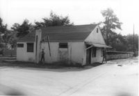
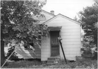
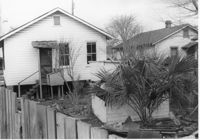
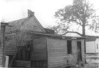
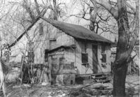
House in dilapidated condition (freedman's cottage) (rear view) on site affected by the construction of Interstate 26 (I-26). Address: 24 Poinsett Street. Surveyor notations on back of photo: "Dkt.: 10.503. Property owner: Frank Brown, Est. Tract: 104. Station: 5921+70 Rt. Date: Feb. 20, 1963. In R/W - Bought." [See collection description for explanation of surveyor notations.]
House (freedman's cottage) on site affected by the construction of Interstate 26 (I-26). Address: 21 Addison Street. Surveyor notations on back of photo: "Dkt.: 10.503. Property owner: Andrew R. Bland. Tract: 97. Station: 5919+90 Rt. Date: Feb. 20, 1963. In R/W - Bought." [See collection description for explanation of surveyor notations.]
House (rear view) on site affected by the construction of Interstate 26 (I-26). Address: 11 Maple Street. Surveyor notations on back of photo: "Dkt.: 10.503. Property owner: James L. Tyler. Tract: 54. Station: 5907+50 Rt. Date: Feb. 19, 1963. In R/W - Bought." [See collection description for explanation of surveyor notations.]
House on site affected by the construction of Interstate 26 (I-26). Address: 9 Maple Street. Surveyor notations on back of photo: "Dkt.: 10.503. Property owner: Kiki Zicoupolis, et al. Tract: 55. Station: 5907+45 CL. Date: Feb. 19, 1963. In R/W - Bought." [See collection description for explanation of surveyor notations.]
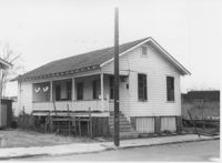
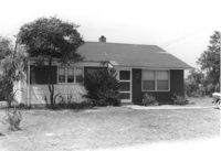
House on site affected by the construction of Interstate 26 (I-26). Building address number 109. Surveyor notations on back of photo: "Dkt.: 10.480. Property owner: Tujax, Inc. Tract: 283. Station: 5732+70 Lt. (Line B). Date: May 30, 1961. In R/W - Bought." [See collection description for explanation of surveyor notations.]
House (rear view) on site affected by the construction of Interstate 26 (I-26). Address: 5 Maple Street. Surveyor notations on back of photo: "Dkt.: 10.503. Property owner: Harry B. Chassereau. Tract: 57. Station: 5907+35 Lt. Date: Feb. 19, 1963." [See collection description for explanation of surveyor notations.]
House on site affected by the construction of Interstate 26 (I-26). Address: 7 Maple Street. Surveyor notations on back of photo: "Dkt.: 10.503. Property owner: James M. Knox. Tract: 56. Station: 5907+45 Lt. Date: Feb. 19, 1963. In R/W - Bought." [See collection description for explanation of surveyor notations.]
House on site affected by the construction of Interstate 26 (I-26). Address: 11 Maple Street. Surveyor notations on back of photo: "Dkt.: 10.503. Property owner: James L. Tyler. Tract: 54. Station: 5907+50 Rt. Date: Feb. 19, 1963. In R/W - Bought." [See collection description for explanation of surveyor notations.]
House on site affected by the construction of Interstate 26 (I-26).Address: 5 Maple Street. Surveyor notations on back of photo: "Dkt.: 10.503. Property owner: Harry B. Chassereau. Tract: 57. Station: 5907+35 Lt. Date: Feb. 19, 1963." [See collection description for explanation of surveyor notations.]
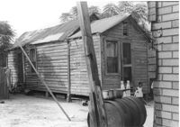
Dilapidated dwelling (rear view) on site affected by the construction of Interstate 26 (I-26). Address: 22½ Poinsett Street. Surveyor notations on back of photo: "Dkt.: 10.503. Property owner: J.W. Blanchard, Est. Tract: 102. Station: 5921+80 Lt. Date: Feb. 20, 1963. In R/W - Bought." [See collection description for explanation of surveyor notations.]
House on site affected by the construction of Interstate 26 (I-26). Building address number 191. Driveway leads to garage/shed. Surveyor notations on back of photo: "Dkt.: 10.480. Property owner: John S. Singleton. Tract: 132. Station: 5652+80 Rt. Date: May 1, 1961. In R/W - Bought." [See collection description for explanation of surveyor notations.]
Dilapidated dwelling on site affected by the construction of Interstate 26 (I-26). Address: 22½ Poinsett Street (rear). Surveyor notations on back of photo: "Dkt.: 10.503. Property owner: J.W. Blanchard, Est. Tract: 102. Station: 5921+00 Lt. Date: Feb. 20, 1963. In R/W - Bought." [See collection description for explanation of surveyor notations.]
Dilapidated dwelling on site affected by the construction of Interstate 26 (I-26). Address: 22½ Poinsett Street. Surveyor notations on back of photo: "Dkt.: 10.503. Property owner: J.W. Blanchard, Est. Tract: 102. Station: 5921+80 Lt. Date: Feb. 20, 1963. In R/W - Bought." [See collection description for explanation of surveyor notations.]
House (rear view) on site affected by the construction of Interstate 26 (I-26). Address: 22 Riker Street. Surveyor notations on back of photo: "Dkt.: 10.503. Property owner: Gibbs Mitchell, Est. Tract: 66. Station: 5910+50 Rt. Date: Feb. 20, 1963. In R/W - Bought." [See collection description for explanation of surveyor notations.]
House on site affected by the construction of Interstate 26 (I-26). Building address number 209. Surveyor notations on back of photo: "Dkt.: 10.480. Property owner: Donald L. Gibson, et al. Tract: 141. Station: 5658+30 Rt. Date: May 2, 1961. In R/W - Bought." [See collection description for explanation of surveyor notations.]
House on site affected by the construction of Interstate 26 (I-26). Address: 22 Riker Street. Surveyor notations on back of photo: "Dkt.: 10.503. Property owner: Gibbs Mitchell, Est. Tract: 66. Station: 5910+50 Rt. Date: Feb. 20, 1963. In R/W - Bought." [See collection description for explanation of surveyor notations.]
House on site affected by the construction of Interstate 26 (I-26). Neighboring church in background. Surveyor notations on back of photo: "Dkt.: 10.480. Property owner: Joseph Perry. Tract: 35. Station: 5507+40 Lt. Date: May 1, 1961. In R/W - Bought." [See collection description for explanation of surveyor notations.]
House (freedman's cottage) and neighboring structures (rear view) on site affected by the construction of Interstate 26 (I-26). Address: 146 Cooper Street. (1951 Sanborn map indicates the address is 94-92A Cooper Street.) Surveyor notations on back of photo: "Dkt.: 10.517. Property owner: Felix J. McKnight, et al. Tract: 65. Station: 5957+85 Lt. - Line 4. Date: March 5, 1963. All in R/W." [See collection description for explanation of surveyor notations.]
House (corner view, rear) on site affected by the construction of Interstate 26 (I-26). Address: 95 Lee Street. Surveyor notations on back of photo: "Dkt.: 10.517. Property owner: Church of God of Prophecy. Tract: 54. Station: 5955+00 CL. Date: February 21, 1963. In R/W - Bought." [See collection description for explanation of surveyor notations.]
House (rear view) on site affected by the construction of Interstate 26 (I-26). Surveyor notations on back of photo: "Dkt.: 10.480. Property owner: Eugene J. Poteat. Tract: 201. Station: 5689+50 Lt. Date: May 31, 1961. In R/W - Bought." [See collection description for explanation of surveyor notations.]
House (rear view) on site affected by the construction of Interstate 26 (I-26). Surveyor notations on back of photo: "Dkt.: 10.480. Property owner: Joseph A. Elsey. Tract: 200. Station: 5689+70 Rt. Date: May 31, 1961. In R/W - Bought." [See collection description for explanation of surveyor notations.]
House on site affected by the construction of Interstate 26 (I-26). Surveyor notations on back of photo: "Dkt.: 10.480. Property owner: Crider O. Murray. Tract: 202. Station: 5689+90 Lt. Date: May 31, 1961. In R/W - Bought." [See collection description for explanation of surveyor notations.]