Search
« Previous |
401 - 500 of 1,683
|
Next »
Search Results
Date:
1977-1983
Description:
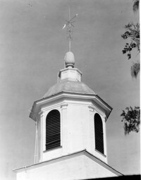
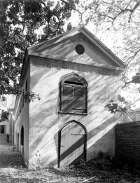
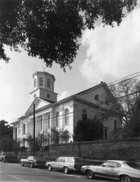
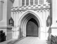
Charleston County, Edisto Island Presbyterian Church, ca. 1831. Church - Detail View of cupola. 4" x 5" B/W photo.
Date:
1977-1983
Description:
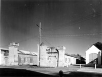
Camden Depot of the S.C.R.R., ca. 1845; South side of Ann Street between Meeting and King Streets. Attributed to E.B. White, architect. View of entry from the NW. 4" x 5" B/W photo.
Date:
1977-1983
Description:
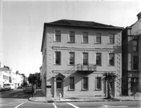
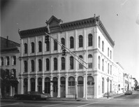
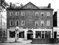
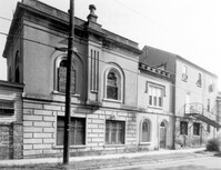
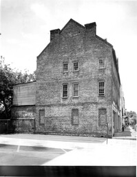
49 Broad Street, Benjamin Smith Building, ca. 1740. View of North (Front) elevation. 4" x 5" B/W photo.
Date:
1977-1983
Description:
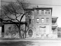
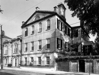
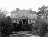
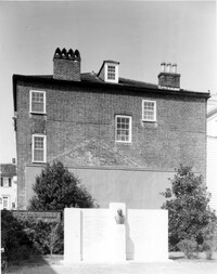
48 Elizabeth Street, Aiken-Rhett House, ca.1818. Main House - View of West (Side) elevation. 4" x 5" B/W photo.
Date:
1977-1983
Description:
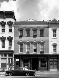
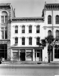
43, 45, 47 Broad Street, ca. 1855. View of NW (Front and Side) elevation. 4" x 5" B/W photo.
Date:
1977-1983
Description:
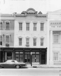
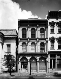
36 Broad Street, ca. 1803. View of North (Front) elevation. 4" x 5" B/W photo.
Date:
1977-1983
Description:
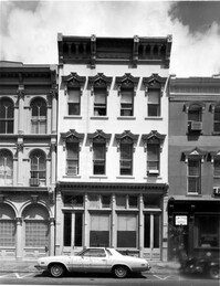
38 Broad Street, ca. 1801. View of South (Front) elevation. 4" x 5" B/W photo.
Date:
1977-1983
Description:
37 Broad Street, ca. 1794. View of North (Front) elevation. 4" x 5" B/W photo.
Date:
1977-1983
Description:
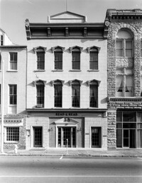
41 Broad Street, ca. 1835. View of North (Front) elevation. 4" x 5" B/W photo.
Date:
1977-1983
Description:
42 Broad Street, ca. 1797. View of South (Front) elevation. 4" x 5" B/W photo.
Date:
1977-1983
Description:
40 Broad Street, ca. 1740. View of South (Front) elevation. 4" x 5" B/W photo.
Date:
1977-1983
Description:
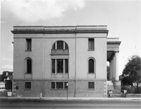
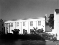
100 Meeting Street, Fireproof Building, ca. 1822. View of West (Side) elevation 4" x 5" B/W photo.
Date:
1977-1983
Description:
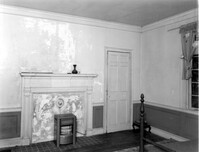
Orangeburg County, Rocks Plantation (The Rocks), ca. 1805. Main House - Interior View. 2nd Floor - NW Room, South wall. 4" x 5" B/W photo.
Date:
1977-1983
Description:
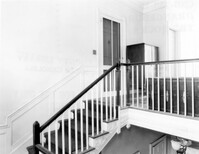
Orangeburg County, Rocks Plantation (The Rocks), ca. 1805. Main House - Interior View. 2nd Floor - Stair Landing. 4" x 5" B/W photo.
Date:
1977-1983
Description:
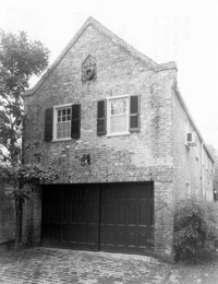
32 South Battery, Colonel John Ashe House, ca. 1762. Carriage House - View of South (Front) elevation. 4" x 5" B/W photo.
Date:
1977-1983
Description:
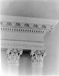
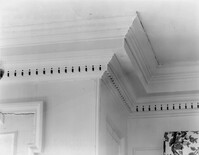
286 Meeting Street, Noyer-Wildhagen House, ca. 1807. Detail View of Console and Cornice. 4" x 5" B/W photo.
Date:
1977-1983
Description:
85 - 87 Broad Street, Josiah Smith Tenement, ca. 1795. View of North (Front) elevation. 4" x 5" B/W photo.
Date:
1977-1983
Description:
85 - 87 Broad Street, Josiah Smith Tenement, ca. 1795. View of South (Rear) elevation. 4" x 5" B/W photo.
Date:
1977-1983
Description:
68 Spring Street, Karpeles Manuscript Library Museum (St. James United Methodist Church), ca. 1858. Interior View - Detail of balcony railing and supporting cast column. 4" x 5" B/W photo.
Date:
1977-1983
Description:
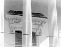
68 Spring Street, Karpeles Manuscript Library Museum (St. James United Methodist Church), ca. 1858. Detail View of column cap and cornice, South (Front) elevation. 4" x 5" B/W photo.
Date:
1977-1983
Description:
68 Spring Street, Karpeles Manuscript Library Museum (St. James United Methodist Church), ca. 1858. Interior View - Detail of reredos entablature and column cap. 4" x 5" B/W photo.
Date:
1977-1983
Description:
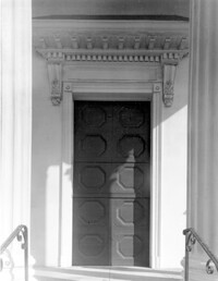
68 Spring Street, Karpeles Manuscript Library Museum (St. James United Methodist Church), ca. 1858. Detail View of door and frontispiece, South (Front) elevation. 4" x 5" B/W photo.
Date:
1977-1983
Description:
68 Spring Street, Karpeles Manuscript Library Museum (St. James United Methodist Church), ca. 1858. Detail View of door entablature, South (Front) elevation. 4" x 5" B/W photo.
Date:
1977-1983
Description:
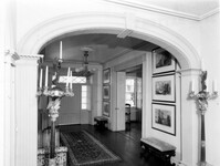
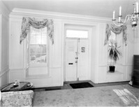
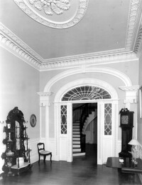
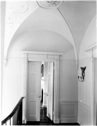
21 East Battery, Edmonston-Alston House, ca. 1828. Main House - Interior View. Ground Floor - East and South Hall intersection, North elevation. 4" x 5" B/W photo.
Date:
1977-1983
Description:
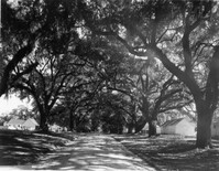
Georgetown County, Mansfield Plantation, ca. 1718. View of Oak Allee. 4" x 5" B/W photo.
Date:
1977-1983
Description:
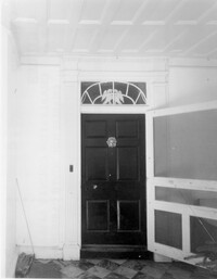
6 Gibbes Street, Parker-Drayton House, ca.1806. Detail View of Ground Floor East end entry, South (Front) elevation. 4" x 5" B/W photo.
Date:
1977-1983
Description:
60 Wentworth Street, Centenary Methodist Church, ca. 1842. View of NE (Side and Rear) elevation. 4" x 5" B/W photo.
Date:
1977-1983
Description:
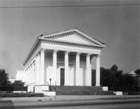
100 Wentworth Street, Grace Episcopal Church, ca. 1847. View of West (Side) elevation. 4" x 5" B/W photo.
Date:
1977-1983
Description:
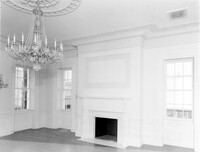
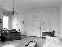
456 King Street, William Aiken House, ca. 1811. Main House - Interior View. 1st Floor - West Room, North wall. 4" x 5" B/W photo.
Date:
1977-1983
Description:
456 King Street, William Aiken House, ca. 1811. Main House - Interior View. 1st Floor - Ballroom, looking SE 4" x 5" B/W photo.
Date:
1977-1983
Description:
14 George Street, Middleton-Pinckney House, ca. 1796. Interior View - 2nd Floor. Detail of door from NW room to hall. 4" x 5" B/W photo.
Date:
1977-1983
Description:
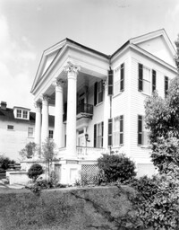
21 East Battery, Edmonston-Alston House, ca. 1828. Main House - View of East (Front) elevation. 4" x 5" B/W photo.
Date:
1977-1983
Description:
9 East Battery, Roper House, ca. 1842. Detail View of entry, East (Front) elevation. 4" x 5" B/W photo.
Date:
1977-1983
Description:
274 Calhoun Street, Daniel Cannon House, ca. 1802. View of SW (Front and Side) elevation. 4" x 5" B/W photo.
Date:
1977-1983
Description:
48 Elizabeth Street, Aiken-Rhett House, ca.1818. Courtyard - View of South elevation from North side of Main House. 4" x 5" B/W photo.
Date:
1977-1983
Description:
172 Rutledge Avenue, Ashley Hall, ca. 1802. Carriage House - View of NE (Rear and Side) elevation. 4" x 5" B/W photo.
Date:
1977-1983
Description:
172 Rutledge Avenue, Ashley Hall, ca. 1802. Main House - View of NW (Rear and Side) elevation. 4" x 5" B/W photo.
Date:
1977-1983
Description:
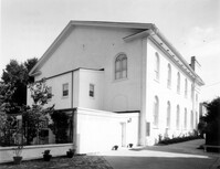
172 Rutledge Avenue, Ashley Hall, ca. 1802. 4" x 5" B/W photo.
Date:
1977-1983
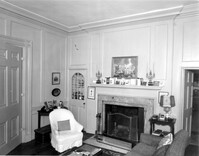
Description:
69 Barre Street, Gov. Thomas Bennett House, ca. 1822. Main House - Interior View. 1st Floor - Hall, looking South 4" x 5" B/W photo.
Date:
1977-1983
Description:
9 East Battery, Roper House, ca. 1842. Detail View of balcony and cornice. 2nd Floor, East (Front) elevation. 4" x 5" B/W photo.
Date:
1977-1983
Description:
64 South Battery, William Gibbes House, ca. 1772. Main House - View of North (Rear) elevation. 4" x 5" B/W photo.
Date:
1977-1983
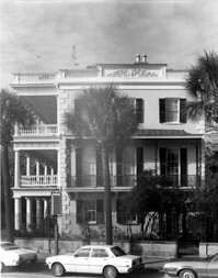
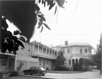
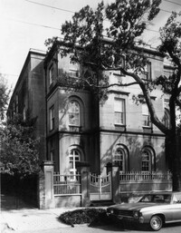
Description:
26 South Battery, Colonel John Algernon Sydney Ashe House, ca. 1853. Main House and Dependencies - North elevation (Rear of House, Front of Dependencies). 4" x 5" B/W photo.
Date:
1977-1983
Description:
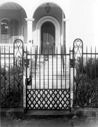
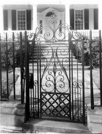
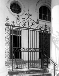
26 South Battery, Colonel John Algernon Sydney Ashe House, ca. 1853. Main House - Detail View of entry gate, South (Front) elevation. 4" x 5" B/W photo.
Date:
1977-1983
Description:
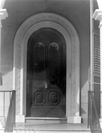
26 South Battery, Colonel John Algernon Sydney Ashe House, ca. 1853. Main House - Detail View of front entry, South (Front) elevation. 4" x 5" B/W photo.
Date:
1977-1983
Description:
342 Meeting Street, Second Presbyterian Church, ca. 1811. View of SE (Rear and Side) elevation. 4" x 5" B/W photo.
Date:
1977-1983
Description:
275 Meeting Street, Trinity Methodist Church, ca. 1848. View of East (Front) elevation. 4" x 5" B/W photo.
Date:
1977-1983
Description:
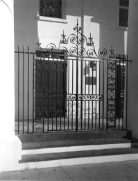
32 South Battery, Colonel John Ashe House, ca. 1762. Main House - Detail View of entry gate, South (Front) elevation. 4" x 5" B/W photo.
Date:
1977-1983
Description:
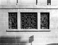
100 Meeting Street, Fireproof Building, ca. 1822. Detail View of Ground Floor window guard, West (Side) elevation 4" x 5" B/W photo.
Date:
1977-1983
Description:
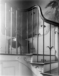
64 South Battery, William Gibbes House, ca. 1772. Main House - Interior. 1st Floor - Hall, Detail of stair landing easement. 4" x 5" B/W photo.
Date:
1977-1983
Description:
2 - 4 Court House Square, Daniel Blake Tenements, ca. 1760. Interior View - 2nd Floor. SW Room, Detail view of cornice. 4" x 5" B/W photo.
Date:
1977-1983
Description:
2 - 4 Court House Square, Daniel Blake Tenements, ca. 1760. Interior View - 1st Floor. SW Room, North elevation. 4" x 5" B/W photo.
Date:
1977-1983
Description:
2 - 4 Court House Square, Daniel Blake Tenements, ca. 1760. Interior View - 1st Floor. SW Room, South elevation. 4" x 5" B/W photo.
Date:
1977-1983
Description:
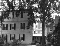
26 Meeting Street, William Mason Smith House, ca. 1819. View of NW (Front and Side) elevation. 4" x 5" B/W photo.
Date:
1977-1983
Description:
85 - 87 Broad Street, Josiah Smith Tenement, ca. 1795. View of East (Side) elevation. 4" x 5" B/W photo.
Date:
1977-1983
Description:
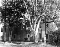
Berkley County, Lewisfield, ca. 1744. View of South (Side) elevation. 4" x 5" B/W photo.
Date:
1977-1983
Description:
Berkley County, Lewisfield, ca. 1744. View of East (Front) elevation. 4" x 5" B/W photo.
Date:
1977-1983
Description:
110 Broad Street, William Harvey House, ca. 1728. Main House - View of East (Side) elevation. 4" x 5" B/W photo.
Date:
1977-1983
Description:
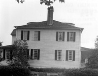
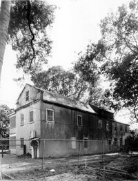
Charleston County, William Seabrook-Dodge Plantation, ca. 1810. View of North (Rear) elevation. 4" x 5" B/W photo.
Date:
1977-1983
Description:
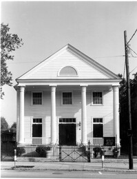
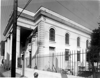
222 Calhoun Street, Old Bethel Methodist Church, ca. 1797. View of South (Front) elevation. 4" x 5" B/W photo.
Date:
1977-1983
Description:
60 - 64 Broad Street, The Confederate Home, ca. 1800. Detail View of portico entry, South (Front) elevation. 4" x 5" B/W photo.
Date:
1977-1983
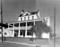
Description:
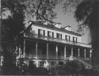
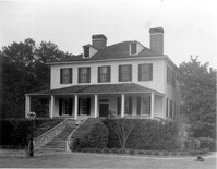
69 Barre Street, Gov. Thomas Bennett House, ca. 1822. Main House - View of NE (Front and Side) elevation. 4" x 5" B/W photo.
Date:
1977-1983
Description:
69 Barre Street, Gov. Thomas Bennett House, ca. 1822. Dependency - View of NE (Front and Side) elevation. 4" x 5" B/W photo.
Date:
1977-1983
Description:
69 Barre Street, Gov. Thomas Bennett House, ca. 1822. Dependency - View of NW (Front and Side) elevation. 4" x 5" B/W photo.
Date:
1886
Description:
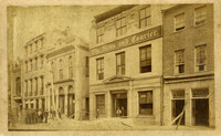
Charleston Earthquake scene. Written on front, at bottom: 'Broad St.' Image shows The News and Courier. Charleston city directory for 1886 lists it at 19 Broad Street.
Date:
1886
Description:
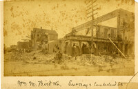
Charleston Earthquake scene. Written on front, at bottom: 'Wm M. Bird & Co. East Bay & Cumberland St.' Sign on building reads: '205, Wm. M. Bird & Co' and '203, Wm E. Holmes.'
Date:
1977-1983
Description:
89 Hasell Street, St. Mary's Roman Catholic Church, ca. 1840. Detail View of wrought iron entry gates, North (Front) elevation. 4" x 5" B/W photo.
Date:
1977-1983
Description:
48 Hasell Street, St. Johannes Lutheran Church, ca. 1842. Detail View of wrought iron gates, East (Front) elevation. 4" x 5" B/W photo.
Date:
1977-1983
Description:
89 Hasell Street, St. Mary's Roman Catholic Church, ca. 1840. View of NW (Front and Side) elevation. 4" x 5" B/W photo.
Date:
1977-1983
Description:
89 Hasell Street, St. Mary's Roman Catholic Church, ca. 1840. View of North (Front) elevation. 4" x 5" B/W photo.
Date:
1977-1983
Description:
48 Hasell Street, St. Johannes Lutheran Church, ca. 1842. View of South (Side) elevation. 4" x 5" B/W photo.
Date:
1977-1983
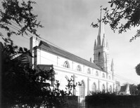
Description:
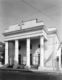
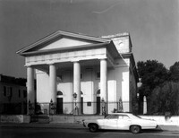
61 Church Street, First Baptist Church, ca. 1822. View of East (Front) elevation. 4" x 5" B/W photo.
Date:
1977-1983
Description:
61 Church Street, First Baptist Church, ca. 1822. View of SW (Rear and Side) elevation. 4" x 5" B/W photo.
Date:
1977-1983
Description:
172 Tradd Street, Chisolm-Alston House, ca. 1836. Detail View of porch, SE (Front and Side) elevation. 4" x 5" B/W photo.
Date:
1977-1983
Description:
106 Tradd Street, Colonel John Stuart House, ca. 1772. Carriage House - View of South (Front) elevation. 4" x 5" B/W photo.
Date:
1977-1983
Description:
Charleston County, William Seabrook-Dodge Plantation, ca. 1810. Detail View of main entry on 1st Floor, South (Front) elevation. 4" x 5" B/W photo.
Date:
1977-1983
Description:
Charleston County, William Seabrook-Dodge Plantation, ca. 1810. Detail View of portico (1st Floor) cornice, South (Front) elevation. 4" x 5" B/W photo.
Date:
1977-1983
Description:
172 Rutledge Avenue, Ashley Hall, ca. 1802. Main House - Interior View. 1st Floor - View of West Double Room, oval East wall and South end of room. 4" x 5" B/W photo.
Date:
1977-1983
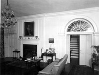
Description:
69 Barre Street, Gov. Thomas Bennett House, ca. 1822. Main House - Interior View. 1st Floor - Hall, looking North. 4" x 5" B/W photo.
Date:
1977-1983
Description:
100 Wentworth Street, Grace Episcopal Church, ca. 1847. Detail View of entry, South (Front) elevation. 4" x 5" B/W photo.
Date:
1977-1983
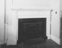
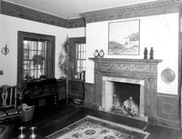
Description:
286 Calhoun Street, Jonathan Lucas House, ca. 1809. Main House - Interior View. 1st Floor - SE Room, Detail of mantle. 4" x 5" B/W photo.
Date:
1977-1983
Description:
100 Wentworth Street, Grace Episcopal Church, ca. 1847. View of SE (Front and Side) elevation. 4" x 5" B/W photo.
Date:
1977-1983
Description:
100 Wentworth Street, Grace Episcopal Church, ca. 1847. View of NW (Side and Rear) elevation. 4" x 5" B/W photo.
Date:
1977-1983
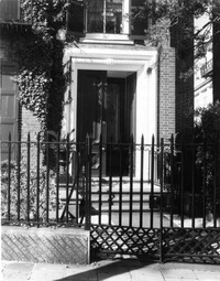
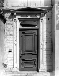
Description:
70 Tradd Street, Judge Robert Pringle House, ca. 1774. Main House - Detail View of Entry, South (Front) elevation. 4" x 5" B/W photo.
Date:
1977-1983
Description:
70 Tradd Street, Judge Robert Pringle House, ca. 1774. Kitchen Building - View of NW (Front and Side) elevation. 4" x 5" B/W photo.
Date:
1977-1983
Description:
192 Ashley Avenue, Wickenberg House, ca. 1859. Detail View of 1st Floor door and window cornices, West (Front) elevation. 4" x 5" B/W photo.
Date:
1977-1983
Description:
69 Barre Street, Gov. Thomas Bennett House, ca. 1822. Main House - Detail View of front staircase, North elevation. 4" x 5" B/W photo.
Date:
1977-1983
Description:
69 Barre Street, Gov. Thomas Bennett House, ca. 1822. Main House - Detail View of piazza entry, East (Front) elevation. 4" x 5" B/W photo.
Date:
1977-1983
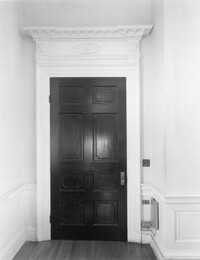
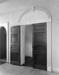
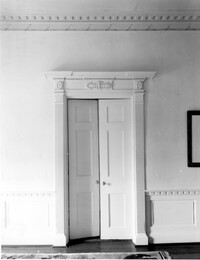
Description:
14 George Street, Middleton-Pinckney House, ca. 1796. Interior View - 1st Floor. Detail of double doors. 4" x 5" B/W photo.
Date:
1977-1983
Description:
2 Amherst Street, Christopher Belser House, ca. 1804. Interior View - Ground Floor, West wall. 4" x 5" B/W photo.
Date:
1977-1983
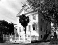
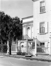
Description:
2 Amherst Street, Christopher Belser House, ca. 1804. View of South (Front) elevation. 4" x 5" B/W photo.
Date:
1977-1983
Description:
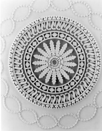
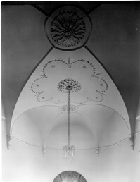
10 Archdale Street, Saint John's Lutheran Church, ca. 1816. Interior View - Detail of ceiling medallion B. 4" x 5" B/W photo.
Date:
1977-1983
Description:
19 Archdale Street, Philip Porcher House, ca. 1765. Interior View - 1st Floor. NE Room, North elevation. 4" x 5" B/W photo.
Date:
1977-1983
Description:
19 Archdale Street, Philip Porcher House, ca. 1765. Interior View - 1st Floor. SE Room, North elevation. 4" x 5" B/W photo.
Date:
1977-1983
Description:
19 Archdale Street, Philip Porcher House, ca. 1765. Detail View of Staircase, SW (Rear and Side) elevation. 4" x 5" B/W photo.
Date:
1977-1983
Description:
2 - 4 Court House Square, Daniel Blake Tenements, ca. 1760. View of East (Side) elevation. 4" x 5" B/W photo.
Date:
1977-1983
Description:
18 Bull Street, William Blacklock House, ca. 1800. Main House - Interior View. 2nd Floor - Stair Hall, Detail of ceiling from South Center Room. 4" x 5" B/W photo.
Date:
1977-1983
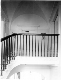
Description:
18 Bull Street, William Blacklock House, ca. 1800. Main House - Interior View. 2nd Floor - Stair Hall, Detail of landing frieze and balustrade. 4" x 5" B/W photo.
Date:
1977-1983
Description:
18 Bull Street, William Blacklock House, ca. 1800. Main House - Interior View. 2nd Floor - Center Room, Detail of door to SW Room. 4" x 5" B/W photo.
Date:
1977-1983
Description:
18 Bull Street, William Blacklock House, ca. 1800. Main House - Interior View. 2nd Floor - Stair Hall, looking West. 4" x 5" B/W photo.
Date:
1977-1983
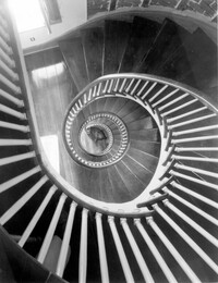
Description:
2 Amherst Street, Christopher Belser House, ca. 1804. Interior View - Stair Tower, Detail of spiral stair from attic. 4" x 5" B/W photo.