Search
« Previous |
1,601 - 1,650 of 1,683
|
Next »
Search Results
Date:
1977-1983
Description:
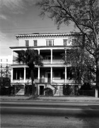
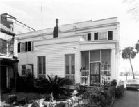
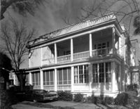
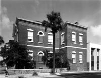
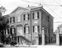
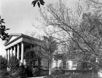
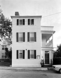
286 Calhoun Street, Jonathan Lucas House, ca. 1809. Main House - View of South (Front) elevation. 4" x 5" B/W photo.
Date:
1977-1983
Description:
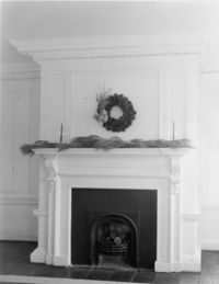
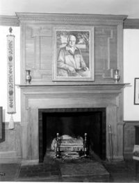
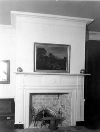
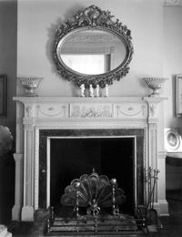
2 - 4 Court House Square, Daniel Blake Tenements, ca. 1760. Interior View - 2nd Floor. SE Room - Detail of mantle, East elevation. 4" x 5" B/W photo.
Date:
1977-1983
Description:
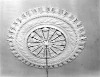
69 Barre Street, Gov. Thomas Bennett House, ca. 1822. Main House - Interior View. 1st Floor - SE Room; Detail of ceiling medallion. 4" x 5" B/W photo.
Date:
1977-1983
Description:
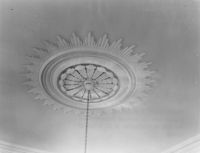
69 Barre Street, Gov. Thomas Bennett House, ca. 1822. Main House - Interior View. 1st Floor - SW Room; Detail of ceiling medallion. 4" x 5" B/W photo.
Date:
1977-1983
Description:
2 - 4 Court House Square, Daniel Blake Tenements, ca. 1760. Interior View - 1st Floor. NE Room, North elevation. 4" x 5" B/W photo.
Date:
1977-1983
Description:
2 - 4 Court House Square, Daniel Blake Tenements, ca. 1760. Interior View - 1st Floor. NW Room, West elevation. 4" x 5" B/W photo.
Date:
1977-1983
Description:
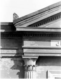
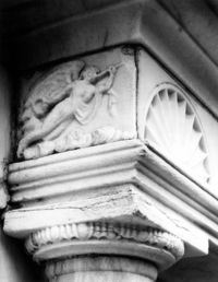
126 Coming Street, Cathedral Church of St. Luke and St. Paul, ca. 1816. Cemetery - Johnson mausoleum. Detail View of entablature and column cap detail, South (Front) elevation. 4" x 5" B/W photo.
Date:
1977-1983
Description:
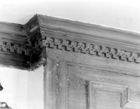
Berkley County, Lewisfield, ca. 1744. Interior View. 1st Floor - SE Room, West wall. Detail of cornice. 4" x 5" B/W photo.
Date:
1977-1983
Description:
Berkley County, Lewisfield, ca. 1744. Interior View. 1st Floor - SE Room, West wall. Detail of mantle. 4" x 5" B/W photo.
Date:
1977-1983
Description:
Berkley County, Lewisfield, ca. 1744. Interior View. 1st Floor - NE Room, West wall. Detail of mantle. 4" x 5" B/W photo.
Date:
1977-1983
Description:
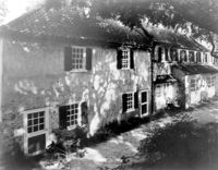
Berkley County, Lewisfield, ca. 1744. Interior View. 1st Floor - SE Room, North and East walls. 4" x 5" B/W photo.
Date:
1977-1983
Description:
108 Beaufain Street, John Steinmeyer House, ca. 1840. View of North (Rear) elevation. 4" x 5" B/W photo.
Date:
1977-1983
Description:
108 Beaufain Street, John Steinmeyer House, ca. 1840. View of West (Side) elevation. 4" x 5" B/W photo.
Date:
1977-1983
Description:
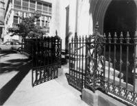
136 Church Street, French Protestant (Huguenot) Church, ca. 1844. Detail View of wrought iron gate and fence, West (Front) elevation. 4" x 5" B/W photo.
Date:
1977-1983
Description:
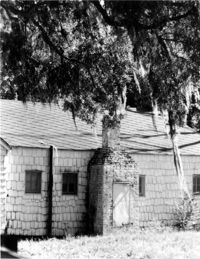
Georgetown County, Mansfield Plantation, ca. 1780. Slave Quarters - Detail View of chimney. 4" x 5" B/W photo.
Date:
1977-1983
Description:
136 Church Street, French Protestant (Huguenot) Church, ca. 1844. Detail View of central window, West (front) elevation. 4" x 5" B/W photo.
Date:
1977-1983
Description:
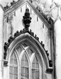
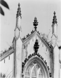
136 Church Street, French Protestant (Huguenot) Church, ca. 1844. Detail View of central gable, West (front) elevation. 4" x 5" B/W photo.
Date:
1977-1983
Description:
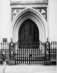
136 Church Street, French Protestant (Huguenot) Church, ca. 1844. Detail View of entry, West (Front) elevation. 4" x 5" B/W photo.
Date:
1977-1983
Description:
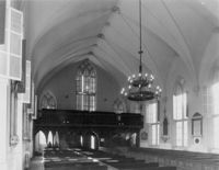
136 Church Street, French Protestant (Huguenot) Church, ca. 1844. Interior View, West (Front) elevation 4" x 5" B/W photo.
Date:
1977-1983
Description:
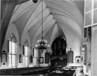
136 Church Street, French Protestant (Huguenot) Church, ca. 1844. Interior View, East (Rear) elevation 4" x 5" B/W photo.
Date:
1977-1983
Description:
50 Broad Street, Bank of South Carolina Building, ca. 1797. View of East (Side) elevation. 4" x 5" B/W photo.
Date:
1977-1983
Description:
89 Beaufain Street, William G. Steele House, ca. 1815. View of entry, NW (Front and Side) elevation. 4" x 5" B/W photo.
Date:
1977-1983
Description:
89 Beaufain Street, William G. Steele House, ca. 1815. View of entry, North (Front) elevation. 4" x 5" B/W photo.
Date:
1977-1983
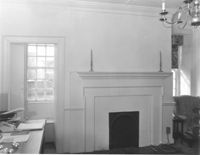
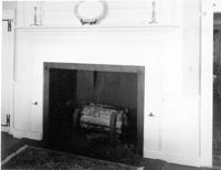
Description:
Berkley County, Loch Dhu, ca. 1812. Main House - Interior View. 1st Floor - SE Room, North wall. Detail of chimneypiece and mantel. 4" x 5" B/W photo.
Date:
1977-1983
Description:
Georgetown County, Beneventum Plantation, ca. 1746. Interior View - 1st Floor. SW Room, Detail of mantle. 4" x 5" B/W photo.
Date:
1977-1983
Description:
Georgetown County, Beneventum Plantation, ca. 1746. Interior View - 1st Floor. NE Room, South elevation. 4" x 5" B/W photo.
Date:
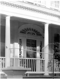
1977-1983
Description:
32 South Battery, Magwood-Moreland House, ca. 1827. Detail View of portico door, West (Side) elevation. 4" x 5" B/W photo.
Date:
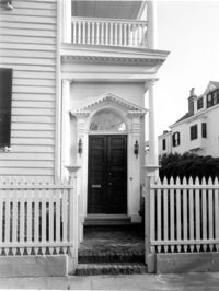
1977-1983
Description:
32 South Battery, Magwood-Moreland House, ca. 1827. Detail View of entry, North (Front) elevation. 4" x 5" B/W photo.
Date:
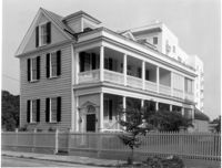
1977-1983
Description:
32 South Battery, Magwood-Moreland House, ca. 1827. View of NW (Front and Side) elevation. 4" x 5" B/W photo.
Date:
1977-1983
Description:
18 Bull Street, William Blacklock House, ca. 1800. Main House - View of SE (Front and Side) elevation 4" x 5" B/W photo.
Date:
1977-1983
Description:
18 Bull Street, William Blacklock House, ca. 1800. Main House - View of West (Side) elevation 4" x 5" B/W photo.
Date:
1977-1983
Description:
32 South Battery, Magwood-Moreland House, ca. 1827. View of North (Front) elevation. 4" x 5" B/W photo.
Date:
1977-1983
Description:
68 South Battery, Harth-Middleton House, ca. 1797. Main House - Interior View. 2nd Floor - SE Drawing Room, Detail of mantle. 4" x 5" B/W photo.
Date:
1977-1983
Description:
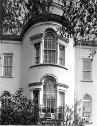
94 Rutledge Avenue, Isaac Jenkins Mikell House, ca. 1851. Main House - View of South (Side) elevation, looking west. 4" x 5" B/W photo.
Date:
1977-1983
Description:
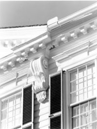
64 South Battery, William Gibbes House, ca. 1772. Main House - Detail View of main cornice and console, South (Front) elevation. 4" x 5" B/W photo.
Date:
1977-1983
Description:
64 South Battery, William Gibbes House, ca. 1772. Dependency - View of NE (Front and Side) elevation. 4" x 5" B/W photo.
Date:
1977-1983
Description:
64 South Battery, William Gibbes House, ca. 1772. Dependency - View of SE (Front and Side) elevation. 4" x 5" B/W photo.
Date:
1977-1983
Description:
49 South Battery, Colonel James English House, ca. 1795. View of North (Front) elevation. 4" x 5" B/W photo.
Date:
1977-1983
Description:
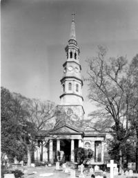
146 Church Street, St. Philip's Episcopal Church, ca. 1836. View of West (Front) elevation. 4" x 5" B/W photo.
Date:
1977-1983
Description:
80 Broad Street, Charleston City Hall, ca. 1800. Detail view of Ground Floor entry cornice, South (Front) elevation. 4" x 5" B/W photo.
Date:
1977-1983
Description:
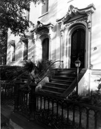
101 - 107 Bull Street, Bee's Row, ca. 1853. Detail View of entries to 101 and 103, North (Front) elevation. 4" x 5" B/W photo.
Date:
1977-1983
Description:
80 Broad Street, Charleston City Hall, ca. 1800. Detail View of bay windows, North (Rear) elevation. 4" x 5" B/W photo.
Date:
1977-1983
Description:
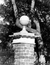
51 Meeting Street, Nathaniel Russell House, ca. 1808. Detail View of front entry gate pier, East (Front) elevation. 4" x 5" B/W photo.
Date:
1977-1983
Description:
14 Legare Street, Simmons-Edwards House, ca. 1800. Stable and Carriage House - View of SW (Front and Side) elevation. 4" x 5" B/W photo.
Date:
1968-06
Description:
152 Gordon Street, view of Guest Room. Charleston, S.C. Originals are 35mm color slides.
Date:
1977-1983
Description:
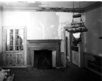
4 Orange Street, Samuel Carne House, ca. 1770. Main House - Interior View. 1st Floor - West Room, North wall. 4" x 5" B/W photo.
Date:
1977-1983
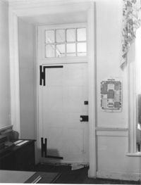
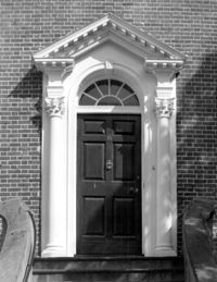
Description:
6 Glebe Street, St. Philip's Parsonage House (Bishop Robert Smith House), ca. 1770. Detail View of entry, South (Front) elevation. 4" x 5" B/W photo.
Date:
1977-1983
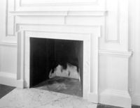
Description:
6 Glebe Street, St. Philip's Parsonage House (Bishop Robert Smith House), ca. 1770. Interior View - Detail of mantle. 4" x 5" B/W photo.
Date:
1977-1983
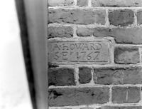
Description:
Berkeley County, St. Stephen's Church, ca. 1767. Detail View of plaque bearing architect/builder's name (A. Howard), South (Side) elevation (located at SE corner). 4" x 5" B/W photo.
Date:
1977-1983
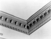
Description:
Berkeley County, St. Stephen's Church, ca. 1767. Detail View of cornice (between flat and cove ceilings). 4" x 5" B/W photo.