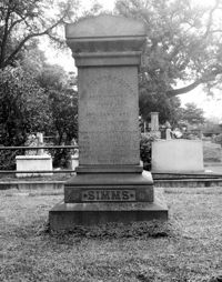
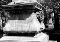
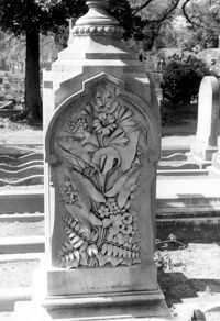
Magnolia Cemetery, Huguenin Avenue and Algonquin Road. Tombstone of William Gilmore Simms. Charleston, S.C.;10" x 8" B/W photo. Box 5, Folder 2-1-3. One copy.
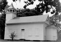
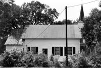
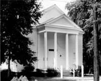
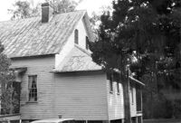
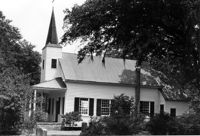
Church of the Redeemer (Pineville Chapel), Matilda Circle. View of SE (Front and Side) elevation. Pineville Historic District. Pineville, SC.;6.5" x 9.5" B/W photo. Box 3, Folder 1-9-1 (I). One copy.
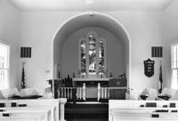
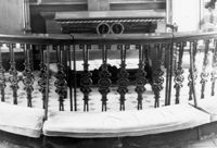
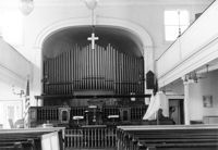
Christ Church Episcopal - Adams Run, State Highway 174. View of Interior. West (Front) elevation. Hollywood, S.C.;6.5" x 10" B/W photo. Box 16, Folder 2-11-12. Three copies.
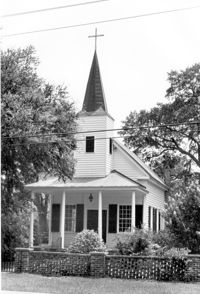
Christ Church Episcopal - Adams Run, State Highway 174. View of North (Side) elevation. Hollywood, S.C.;6.5" x 10" B/W photo. Box 16, Folder 2-11-12. Three copies.
Christ Church Episcopal - Adams Run, State Highway 174. View of West (Front) elevation. Hollywood, S.C.;10" x 6.5" B/W photo. Box 16, Folder 2-11-12. Three copies.
Christ Church Episcopal - Adams Run, State Highway 174. View of South (Side) elevation. Hollywood, S.C.;8" x 10" B/W photo. Box 16, Folder 2-11-12. One copy.
Mount Pleasant Presbyterian Church, 302 Hibben Street (NE corner of Hibben and Church Street). View of SE (Front) elevation. Mount Pleasant, S.C.;6.5" x 10" (and 8" x 10") B/W photo. Box 13, Folder 2-8-6. Two copies.
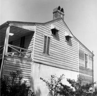
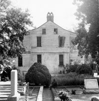
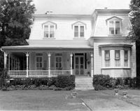
Captain Peter Lewis House, 206 Live Oak Drive. View of South (Front) elevation. Mount Pleasant, S.C.;6.5" x 10" B/W photo. Box 13, Folder 2-8-12. One copy.
Captain Peter Lewis House, 206 Live Oak Drive. View of South (Front) elevation. Mount Pleasant, S.C.;8" x 10" B/W photo. Box 13, Folder 2-8-12. Three copies.
Old Rectory (Gourdin House). View of NNE (Front and Side) elevation. Pineville Historic District. St. Stephen, SC.;6.5" x 9.5" B/W photo. Box 3, Folder 1-9-1 (I). One copy.
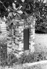
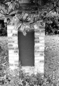
Quarter House Fort & Tavern Site, Success Street (between Meeting Street Road and Rivers Avenue). Detail View of Tavern Entrance Post and Historical Marker. Front and Side elevation. North Charleston, S.C.;10" x 6.5" B/W photo. Box 5, Folder 2-1-10. One copy.
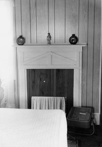
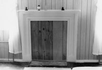
Mary Lesesne House (B.C. Cox House), ca. 1790. Interior View - 2nd Floor, Central Room. Detail of Mantel. Cainhoy, S.C.;9.5" x 6.5" B/W photo. Box 4, Folder 1-12-3. One copy.
Mary Lesesne House (B.C. Cox House), ca. 1790. Interior View - 1st Floor, East Room. Detail of Mantel. Cainhoy, S.C.;6.5" x 9.5" B/W photo. Box 4, Folder 1-12-3. One copy.
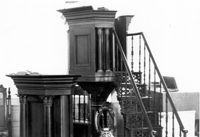
St. Andrews Episcopal Church (Old St. Andrews Parish Church), 2604 Ashley River Road. Interior View - Detail of Pulpit and Lectern. West elevation. Charleston, S.C.;6.5" x 10" B/W photo. Box 14, Folder 2-9-7. One copy.
St. Andrews Episcopal Church (Old St. Andrews Parish Church), 2604 Ashley River Road. Interior View - Detail of Altar Kneelers. East elevation. Charleston, S.C.;6.5" x 10" B/W photo. Box 14, Folder 2-9-7. One copy.
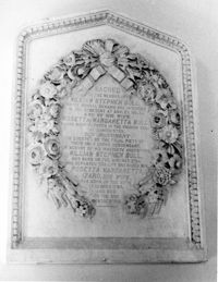
St. Andrews Episcopal Church (Old St. Andrews Parish Church), 2604 Ashley River Road. Interior View - Detail of Altar Plaque. South elevation. Charleston, S.C.;10" x 8" B/W photo. Box 14, Folder 2-9-7. One copy.
St. Andrews Episcopal Church (Old St. Andrews Parish Church), 2604 Ashley River Road. Interior View - Front Entrance. West elevation. Charleston, S.C.;6.5" x 10" B/W photo. Box 14, Folder 2-9-7. One copy.
Quarter House Fort & Tavern Site, Success Street (between Meeting Street Road and Rivers Avenue). Detail View of Tavern Entrance Post and Historical Marker. Front elevation. North Charleston, S.C.;10" x 6.5" B/W photo. Box 5, Folder 2-1-10. One copy.
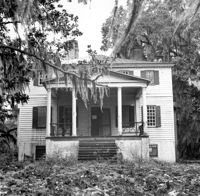
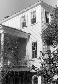
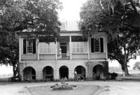
Peter's Point Plantation, off S.C. Hwy 174 on County Road 764 (Peters Point Road). View of SE (Rear) elevation. Edisto Island, S.C.;6.5" x 10" B/W photo. Box 11, Folder 2-3-17. One copy.
McCrady's Tavern and Long Room, 153 East Bay Street. View of South (Front) elevation (looking West from East Bay Street). Charleston, S.C.;10" x 6.5" B/W photo. Box 6, Folder 2-1-31. One copy.
Isaac Porcher House - Main House. View of SE (Side and Rear) elevation. Pinopolis Historic District North. Pinopolis, S.C.;6.5" x 9.5" B/W photo. Box 4, Folder 1-10-1 (III). Two copies.
Isaac Porcher House - Main House. View of SW (Side and Rear) elevation. Pinopolis Historic District North. Pinopolis, S.C.;6.5" x 9.5" B/W photo. Box 4, Folder 1-10-1 (III). Two copies.
Dr. Morton Waring House - Main House. View of North (Front) elevation. Pinopolis Historic District South. Pinopolis, S.C.;6.5" x 9.5" B/W photo. Box 4, Folder 1-10-1 (III). Two copies.
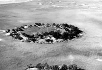
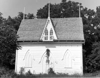
Bleak Hall Plantation, S.C. Hwy. 174. Ice House - View of East (Front) elevation. Edisto Island, S.C.;8" x 10" B/W photo. Box 10, Folder 2-3-2. Two copies.
Old Bethel Methodist Church, 222 Calhoun Street. Interior View - Detail of Chancel and Ceiling. North (Front) elevation. Charleston, S.C.;6.5" x 10" B/W photo. Box 7, Folder 2-1-43. One copy.
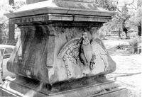
Magnolia Cemetery, Huguenin Avenue and Algonquin Road. Tombstone of Elizabeth DeSaussure Tucker. Charleston, S.C.;10" x 8" B/W photo. Box 5, Folder 2-1-3. One copy.
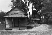
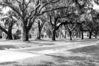
Boone Hall Plantation, Oak Avenue. Slave Cabins - General View of NW (Front and Side) elevation. Mount Pleasant, S.C.;6.5" x 10" B/W photo. Box 10, Folder 2-2-5. One copy.
Old Rectory (Gourdin House). View of Kitchen Addition - West (Side) elevation. Pineville Historic District. St. Stephen, SC.;6.5" x 9.5" B/W photo. Box 3, Folder 1-9-1 (I). One copy.
Old Rectory (Gourdin House). View of NNE (Side and Front) elevation. Pineville Historic District. St. Stephen, SC.;6.5" x 9.5" B/W photo. Box 3, Folder 1-9-1 (I). One copy.
Old Rectory (Gourdin House). View of SW (Rear and Side) elevation. Pineville Historic District. St. Stephen, SC.;6.5" x 9.5" B/W photo. Box 3, Folder 1-9-1 (I). One copy.
Jonathan Lucas Rice Mill, Located along the Cooper River. Contact Sheet 9 - Multiple Views. Berkeley County, S.C.;1.5" x 1" B/W photo. Box 20, Folder: Miscellaneous Photos: Scanned Contact Sheets. One copy.
Library Society Building. View of North (Front) elevation. Pineville Historic District. St. Stephen, SC.;6.5" x 9.5" B/W photo. Box 3, Folder 1-9-1 (I). One copy.
Peachtree Plantation, Located along the South Santee River. Contact Sheet 9 - Multiple Views. McClellenville, S.C.;6" x 1" B/W photo. Box 20, Folder: Miscellaneous Photos: Scanned Contact Sheets. One copy.
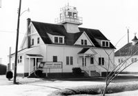
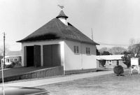
U.S. Coast Guard Historical District, I'on Avenue. Administration Building - View of North (Front) elevation. Sullivans Island, S.C.;6.5" x 10" (and 3.5" x 5") B/W photo. Box 16, Folder 2-13-1. Two copies.
U.S. Coast Guard Historical District, I'on Avenue. Boat House - View of NW (Side and Front) elevation. Sullivans Island, S.C.;6.5" x 10" (and 3.5" x 5") B/W photo. Box 16, Folder 2-13-1. Two copies.
U.S. Coast Guard Historical District, I'on Avenue. Boat House - View of SE (Side and Rear) elevation. Sullivans Island, S.C.;6.5" x 10" (and 3.5" x 5") B/W photo. Box 16, Folder 2-13-1. Two copies.
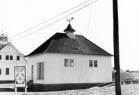
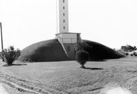
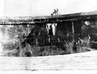
U.S. Coast Guard Historical District, I'on Avenue. Bunker - View of North (Front) elevation. Sullivans Island, S.C.;6.5" x 10" (and 3.5" x 5") B/W photo. Box 16, Folder 2-13-1. Two copies.
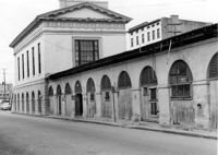
City Market - Market Hall and First Section of Sheds. View of SE (Side and Rear) elevation. Charleston, S.C.;8" x 10" B/W photo. Box 6, Folder 2-1-14. One copy.
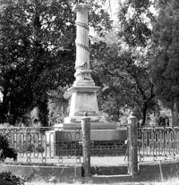
Magnolia Cemetery, Huguenin Avenue and Algonquin Road. Monument of Colonel William Washington. View of South elevation. Charleston, S.C.;8" x 8" B/W photo. Box 5, Folder 2-1-3. One copy.
Halidon Hill Plantation (Quinby Plantation), Approximately 0.5 mile SE from Halidon Hill Lane and Cainhoy Road (S.C. Hwy 98). Main House - View of East (Front) elevation. Huger, S.C.;8" x 10" B/W photo. Box 4, Folder 1-12-6. One copy.
Halidon Hill Plantation (Quinby Plantation), Approximately 0.5 mile SE from Halidon Hill Lane and Cainhoy Road (S.C. Hwy 98). Main House - View of East (Front) elevation. Huger, S.C.;8" x 10" B/W photo. Box 4, Folder 1-12-6. One copy.
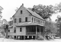
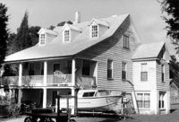
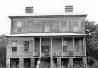
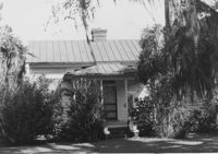
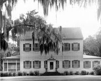
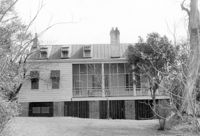
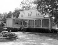
Stiles Point Plantation (Stiles-Hinson-Thompson House), 940 Paul Revere Drive. View of South (Rear) elevation. Charleston S.C.;6.5" x 10" B/W photo. Box 12, Folder 2-4-7. One copy.
Cathedral of St. Luke and St. Paul, 126 Coming Street. Contact Sheet 7 - Views of Rear and Sides elevations. Charleston, S.C.;1" x 9" B/W photo. Box 20, Folder: Miscellaneous Photos: Scanned Contact Sheets. One copy.
Cathedral of St. Luke and St. Paul, 126 Coming Street. Contact Sheet 7 - Views of Interior. Charleston, S.C.;1" x 4.5" B/W photo. Box 20, Folder: Miscellaneous Photos: Scanned Contact Sheets. One copy.
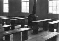
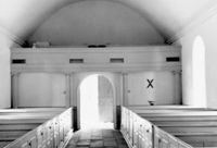
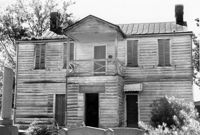
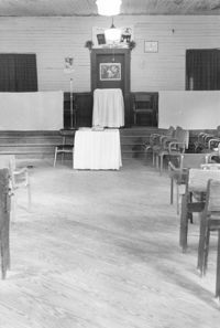
Old Lincolnville Town Hall (Williams Graded School), near intersection of East Randolph Street and East Pinckney Street. View of interior. Lincolnville, S.C.;10" x 6.5" B/W photo. Box 17, Folder 2-15-2. Three copies.
Christ Church Episcopal - Adams Run, State Highway 174. View of South (Side) elevation. Hollywood, S.C.;6.5" x 10" B/W photo. Box 16, Folder 2-11-12. Three copies.
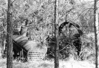
Fairlawn Plantation (Hugh Rose Plantation), Off of Guerins Bridge Road, adjacent to the Francis Marion National Forest. Detail View of Steam Engine for Rice Mill.;6.5" x 10" B/W photo. Box 19, Folder: Charleston County: Christ Church: Fairlawn Plantation. One copy.
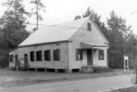
Old Lincolnville Town Hall (Williams Graded School), near intersection of East Randolph Street and East Pinckney Street. View of SW (Front and Side) elevation. Lincolnville, S.C.;6.5" x 10" B/W photo. Box 17, Folder 2-15-2. Two copies.
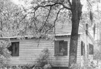
Old Lincolnville Town Hall (Williams Graded School), near intersection of East Randolph Street and East Pinckney Street. View of North (Rear) elevation. Lincolnville, S.C.;6.5" x 10" B/W photo. Box 17, Folder 2-15-2. Three copies.
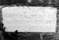
Old Lincolnville Town Hall (Williams Graded School), near intersection of East Randolph Street and East Pinckney Street. Detail View of cornerstone. Lincolnville, S.C.;6.5" x 10" B/W photo. Box 17, Folder 2-15-2. Three copies.
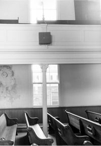
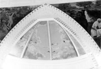
Central Baptist Church, 26 Radcliffe Street. Interior View - Detail of Balcony in Gable. South elevation. Charleston, S.C.;6.5" x 10" B/W photo. Box 9, Folder 2-1-156. One copy.
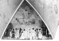
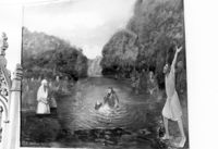
Central Baptist Church, 26 Radcliffe Street. Interior View - Detail of Mural in Apse. South elevation. Charleston, S.C.;6.5" x 10" B/W photo. Box 9, Folder 2-1-156. One copy.
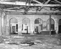
S.C. Railroad Car Shop (AAA Downtown Storage), 44 Line Street. Interior View. Charleston, S.C.;8" x 10" B/W photo. Box 18, Folder: Charleston: 44 Line Street, South Carolina Car Shop. One copy.
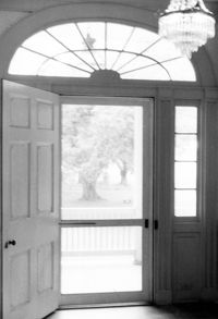
The Grove Plantation (Ernest F. Hollings ACE Basin National Wildlife Refuge). Interior View - 2nd Floor. Detail of Front Door. Adams Run, S.C.;10" x 6.5" B/W photo. Box 15, Folder 2-11-1. One copy.
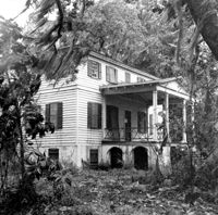
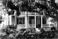
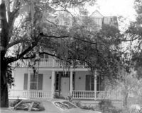
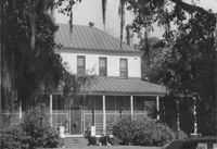
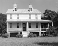
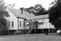
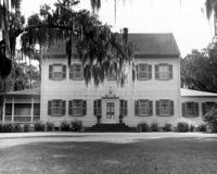
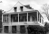
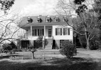
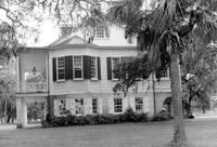
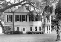
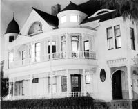
The Grove Plantation (Ernest F. Hollings ACE Basin National Wildlife Refuge). View of the North (Rear) elevation. Adams Run, S.C.;6.5" x 10" B/W photo. Box 15, Folder 2-11-1. One copy.
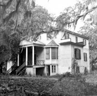
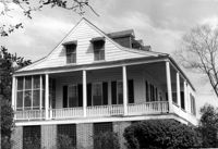
The Grove Plantation (Ernest F. Hollings ACE Basin National Wildlife Refuge). View of East (Side) elevation. Adams Run, S.C.;6.5" x 10" B/W photo. Box 15, Folder 2-11-1. One copy.
The Grove Plantation (Ernest F. Hollings ACE Basin National Wildlife Refuge). View of West (Side) elevation. Adams Run, S.C.;6.5" x 10" B/W photo. Box 15, Folder 2-11-1. One copy.
Cathedral of St. Luke and St. Paul, 126 Coming Street. Contact Sheet 8 - Views of Educational Building and Church. Charleston, S.C.;1" x 6" B/W photo. Box 20, Folder: Miscellaneous Photos: Scanned Contact Sheets. One copy.
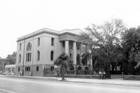
Fireproof Building (South Carolina Historical Society), 100 Meeting Street. View of SW (Side and Front) elevation. Charleston, S.C.;3.5" x 5" B/W photo. Box 5, Folder 2-1-1. One copy.
Fireproof Building (South Carolina Historical Society), 100 Meeting Street. View of SW (Front and Side) elevation. Charleston, S.C.;3.5" x 5" B/W photo. Box 5, Folder 2-1-1. One copy.
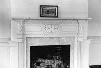
The Grove Plantation (Ernest F. Hollings ACE Basin National Wildlife Refuge). Interior View - 2nd Floor. Detail of Mantle in West Rear Room. Adams Run, S.C.;6.5" x 10" B/W photo. Box 15, Folder 2-11-1. One copy.
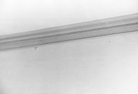
The Grove Plantation (Ernest F. Hollings ACE Basin National Wildlife Refuge). Interior View - 2nd Floor. Detail of Cornice in Front Room. Adams Run, S.C.;6.5" x 10" B/W photo. Box 15, Folder 2-11-1. One copy.
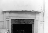
The Grove Plantation (Ernest F. Hollings ACE Basin National Wildlife Refuge). Interior View - 2nd Floor. Detail of Mantle in Front Room. Adams Run, S.C.;6.5" x 10" B/W photo. Box 15, Folder 2-11-1. One copy.
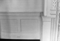
The Grove Plantation (Ernest F. Hollings ACE Basin National Wildlife Refuge). Interior View - 2nd Floor. Detail of Front Room Wainscot. Adams Run, S.C.;6.5" x 10" B/W photo. Box 15, Folder 2-11-1. One copy.
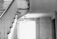
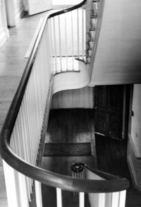
The Grove Plantation (Ernest F. Hollings ACE Basin National Wildlife Refuge). Interior View - 1st Floor. Detail of Stairs and Back Door. Adams Run, S.C.;6.5" x 10" B/W photo. Box 15, Folder 2-11-1. One copy.
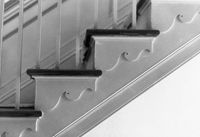
The Grove Plantation (Ernest F. Hollings ACE Basin National Wildlife Refuge). Interior View - 2nd Floor. Detail of Staircase trim. Adams Run, S.C.;6.5" x 10" B/W photo. Box 15, Folder 2-11-1. One copy.
The Grove Plantation (Ernest F. Hollings ACE Basin National Wildlife Refuge). Interior View - 2nd Floor. Detail of Stairwell. Adams Run, S.C.;10" x 6.5" B/W photo. Box 15, Folder 2-11-1. Four copies.
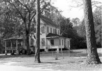
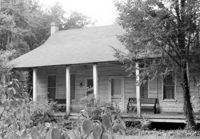
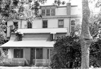
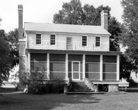
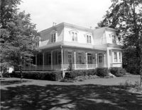
Johns Island Presbyterian Church, 2550 Bohicket Road. Manse - Front elevation. Johns Island, S.C.;6.5" x 10" B/W photo. Box 12, Folder 2-5-4. Two copies.