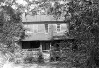
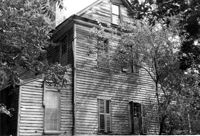
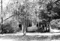
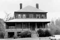
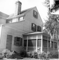
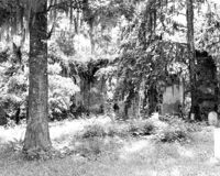
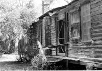
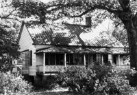
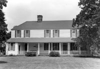
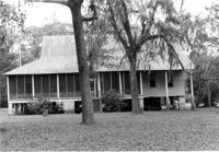
Lucas House, ca. 1835 - Pivotal to Historic District. View of North (Rear) elevation, showing wings and outbuildings. Pinopolis Historic District North. Pinopolis, S.C.;5" x 7" B/W photo. Box 3, Folder 1-10-1 (II). One copy.
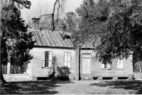
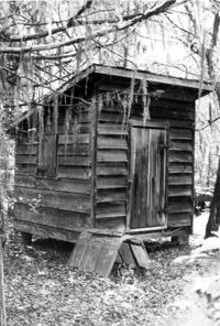
Old Rectory - Outbuilding #2, ca. 1855 - Pivotal to Historic District. View of Front elevation. Pinopolis Historic District South. Pinopolis, S.C.;5" x 7" B/W photo. Box 3, Folder 1-10-1 (II). One copy.
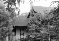
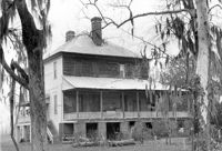
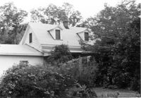
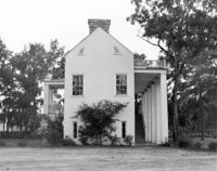
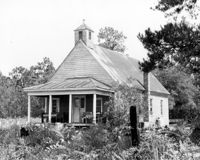
Samuel Porcher Stoney House, ca. 1890 - Pivotal to Historic District. View of Front and Side elevations. Pinopolis, S.C.;5" x 7" B/W photo. Box 3, Folder 1-10-1 (II). Three copies.
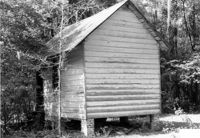
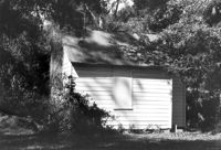
Old Rectory - Outbuilding #1, ca. 1855 - Pivotal to Historic District. View of Front elevation. Pinopolis Historic District South. Pinopolis, S.C.;5" x 7" B/W photo. Box 3, Folder 1-10-1 (II). One copy.
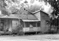
Harriet C. Wilson House, ca. 1905 - Pivotal to Historic District. View of Front elevation. Pinopolis Historic District South. Pinopolis, S.C.;5" x 7" B/W photo. Box 3, Folder 1-10-1 (II). One copy.
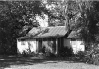
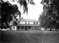
Lucas House, ca. 1835 - Pivotal to Historic District. View of South (Front) elevation. Pinopolis Historic District North. Pinopolis, S.C.;5" x 7" B/W photo. Box 3, Folder 1-10-1 (II). One copy.
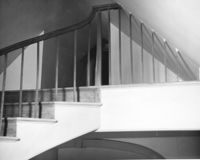
Old Rectory (Gourdin House). Interior View - Detail of Newel Post. WSW elevation. Pineville Historic District. St. Stephen, SC.;6.5" x 9.5" B/W photo. Box 3, Folder 1-9-1 (I). One copy.
William Cain House - Main House. Detail View of Rear Door and Windows, South (Rear) elevation. Pinopolis Historic District North. Pinopolis, S.C.;6.5" x 9.5" B/W photo. Box 4, Folder 1-10-1 (III). Two copies.
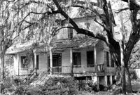
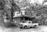
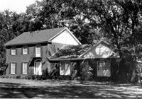
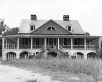
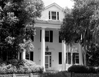
Halidon Hill Plantation (Quinby Plantation), Approximately 0.5 mile SE from Halidon Hill Lane and Cainhoy Road (S.C. Hwy 98). Main House - View of SW (Side and Front) elevation. Huger, S.C.;8" x 10" B/W photo. Box 4, Folder 1-12-6. One copy.
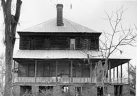
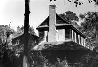
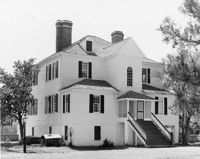
Dr. Morton Waring House - Main House. View of North (Front) elevation, West end of house. Pinopolis Historic District South. Pinopolis, S.C.;6.5" x 9.5" B/W photo. Box 4, Folder 1-10-1 (III). Two copies.
William Cain House - Office. View of NW (Side and Front) elevation. Pinopolis Historic District North. Pinopolis, S.C.;6.5" x 9.5" B/W photo. Box 4, Folder 1-10-1 (III). Two copies.
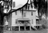
William Robertson House - Main House (Wampee Plantation Summer House). View of NW (Front and Side) elevation. Pinopolis, S.C.;6.5" x 9.5" B/W photo. Box 4, Folder 1-10-1 (III). Two copies.
William Robertson House - Main House (Wampee Plantation Summer House). View of North (Front) elevation. Pinopolis, S.C.;6.5" x 9.5" B/W photo. Box 4, Folder 1-10-1 (III). Two copies.
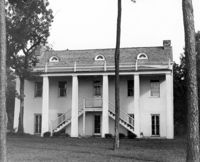
Dr. Morton Waring House - Main House. View of West (Side) elevation. Pinopolis Historic District South. Pinopolis, S.C.;6.5" x 9.5" B/W photo. Box 4, Folder 1-10-1 (III). Two copies.
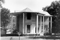
Isaac Porcher House - Main House. View of West (Side) elevation. Pinopolis Historic District North. Pinopolis, S.C.;6.5" x 9.5" B/W photo. Box 4, Folder 1-10-1 (III). Two copies.
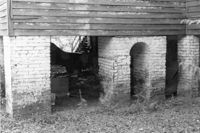
Old Rectory - Main Building. Detail View of Foundation, SW (Side and Rear) elevation. Pinopolis, S.C.;6.5" x 9.5" B/W photo. Box 4, Folder 1-10-1 (III). Two copies.
Old Rectory - Main Building. Detail View of SE (Side and Rear) elevation. Pinopolis, S.C.;6.5" x 9.5" B/W photo. Box 4, Folder 1-10-1 (III). Two copies.
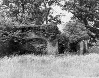
Dean Hall Plantation - Overseers House. Detail View of chimney. Oakley, SC. NOTE: Property relocated to Moncks Corner, S.C.;10" x 8" B/W photo. Box 2, Folder 1-8-9. One copy.
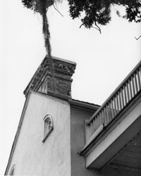
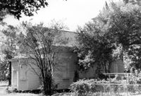
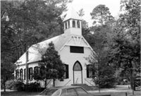
Tavou Church (Taveau Church), Strawberry Ferry Road (S.C. State Road 44). View of Side elevation. Moncks Corner, SC.;6.5" x 9.5" B/W photo. Box 2, Folder 1-3-12. One copy.
Halidon Hill Plantation (Quinby Plantation), Approximately 0.5 mile SE from Halidon Hill Lane and Cainhoy Road (S.C. Hwy 98). Main House, Interior View - Stair Landing leading to Attic. SW elevation. Huger, S.C.;8" x 10" B/W photo. Box 4, Folder 1-12-6. One copy.
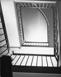
Halidon Hill Plantation (Quinby Plantation), Approximately 0.5 mile SE from Halidon Hill Lane and Cainhoy Road (S.C. Hwy 98). Main House, Interior View - Staircase, looking up. Huger, S.C.;8" x 10" B/W photo. Box 4, Folder 1-12-6. One copy.
Halidon Hill Plantation (Quinby Plantation), Approximately 0.5 mile SE from Halidon Hill Lane and Cainhoy Road (S.C. Hwy 98). Main House - View of NW (Side and Rear) elevation. Huger, S.C.;8" x 8" B/W photo. Box 4, Folder 1-12-6. One copy.
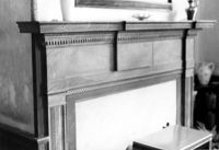
Halidon Hill Plantation (Quinby Plantation), Approximately 0.5 mile SE from Halidon Hill Lane and Cainhoy Road (S.C. Hwy 98). Main House, Interior View - Mantle. Huger, S.C.;8" x 8" B/W photo. Box 4, Folder 1-12-6. One copy.
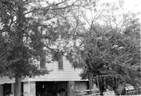
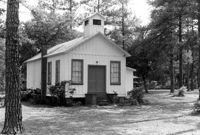
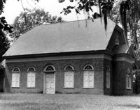
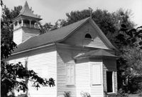
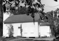
Guild Hall (Church of the Holy Family) - Barrows Historic District. View of Front. Moncks Corner, S.C.;6.5" x 9.5" B/W photo. Box 2, Folder 1-1-1. Three copies.
How Tavern, ca. 1744. View of North (Front) elevation. Cainhoy (Huger vicinity, Lewisville, Louisville), S.C.;8" x 10" B/W photo. Box 4, Folder 1-12-3. One copy.
Church of the Redeemer (Pineville Chapel), Matilda Circle. View of SE (Rear and Side) elevation. Pineville Historic District. Pineville, SC.;6.5" x 9.5" B/W photo. Box 3, Folder 1-9-1 (I). One copy.
Church of the Redeemer (Pineville Chapel), Matilda Circle. View of SE (Side and Rear) elevation. Pineville Historic District. Pineville, SC.;6.5" x 9.5" B/W photo. Box 3, Folder 1-9-1 (I). One copy.
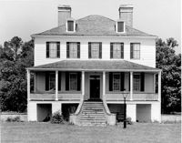
Dr. Morton Waring House - Main House. View of South (Rear) elevation, looking East. Pinopolis Historic District South. Pinopolis, S.C.;6.5" x 9.5" B/W photo. Box 4, Folder 1-10-1 (III). Two copies.
Dr. Morton Waring House - Main House. View of NW (Front and Side) elevation. Pinopolis Historic District South. Pinopolis, S.C.;6.5" x 9.5" B/W photo. Box 4, Folder 1-10-1 (III). Two copies.
William Cain House - Main House. Detail View of Rear Door and Windows, South (Rear) elevation, looking East. Pinopolis Historic District North. Pinopolis, S.C.;6.5" x 9.5" B/W photo. Box 4, Folder 1-10-1 (III). Two copies.
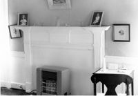
Old Rectory (Gourdin House). Interior View - Detail of Mantle on West Side, 2nd Floor. WNW elevation. Pineville Historic District. St. Stephen, SC.;6.5" x 9.5" B/W photo. Box 3, Folder 1-9-1 (I). One copy.
Unidentified House, ca. Mid 20th century - Non-contributory to Historic District. Front and Side elevations. Pinopolis, S.C.;5" x 7" B/W photo. Box 3, Folder 1-10-1 (II). One copy.
John Grant House, ca. 1901 - Pivotal to Historic District. View of front and Side elevations. Pinopolis Historic District South. Pinopolis, S.C.;5" x 7" B/W photo. Box 3, Folder 1-10-1 (II). One copy.
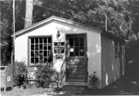
Post Office Building, ca. 1970 - Non-contributory to Historic District. Front and Side elevations. Pinopolis, S.C.;5" x 7" B/W photo. Box 3, Folder 1-10-1 (II). One copy.
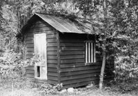
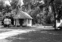
Isaac Porcher Office, ca. 1844 - Pivotal to Historic District. View of Side elevation. Pinopolis, S.C.;5" x 7" B/W photo. Box 3, Folder 1-10-1 (II). One copy.
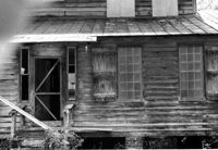
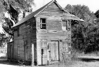
William Cain House, ca. 1834 - Pivotal to Historic District. View of Side and Front elevations. Pinopolis Historic District North. Pinopolis, S.C.;5" x 7" B/W photo. Box 3, Folder 1-10-1 (II). One copy.
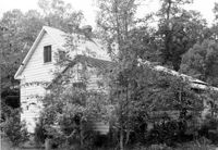
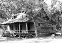
Unidentified House, ca. Early 20th century - Contributory to Historic District. Front elevation. Pinopolis, S.C.;5" x 7" B/W photo. Box 3, Folder 1-10-1 (II). One copy.
Unidentified House, ca. 1910 - Contributory to Historic District. Front elevation. Pinopolis Historic District South. Pinopolis, S.C.;5" x 7" B/W photo. Box 3, Folder 1-10-1 (II). One copy.
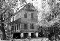
Dean Hall Plantation - Main House. View of NW (Front) elevation. Oakley, SC. NOTE: Property relocated to Beaufort County in 1971.;8" x 10" B/W photo. Box 2, Folder 1-8-8. One copy.
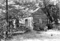
Middleburg Plantation, Middleburg Lane. Commissary - View of Front and Side elevation. Huger, S.C.;6.5" x 9.5" B/W photo. Box 4, Folder 1-12-4. One copy.
William Robertson House - Office (Wampee Plantation Summer House). View of SW (Front and Side) elevation. Pinopolis, S.C.;9.5" x 6.5" B/W photo. Box 4, Folder 1-10-1 (III). Two copies.
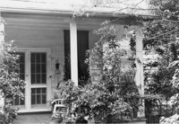
Dr. Morton Waring House - Lodge. Detail View of Front Porch, East (Front) elevation. Pinopolis Historic District South. Pinopolis, S.C.;6.5" x 9.5" B/W photo. Box 4, Folder 1-10-1 (III). Two copies.
Dr. Morton Waring House - Outbuilding. View of NE (Side and Front) elevation. Pinopolis Historic District South. Pinopolis, S.C.;6.5" x 9.5" B/W photo. Box 4, Folder 1-10-1 (III). Two copies.
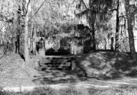
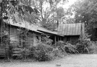
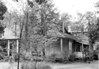
Dean Hall Plantation - Overseers House. View of East (Front) elevation. Oakley, SC. NOTE: Property relocated to Moncks Corner, S.C.;8" x 10" B/W photo. Box 2, Folder 1-8-9. One copy.
Dr. Morton Waring House - Office. View of SE (Front and Side) elevation. Pinopolis Historic District South. Pinopolis, S.C.;6.5" x 9.5" B/W photo. Box 4, Folder 1-10-1 (III). Two copies.
Dr. Morton Waring House - Lodge. View of NW (Side and Rear) elevation. Pinopolis Historic District South. Pinopolis, S.C.;6.5" x 9.5" B/W photo. Box 4, Folder 1-10-1 (III). Two copies.
Dr. Morton Waring House - Lodge. View of East (Front) elevation. Pinopolis Historic District South. Pinopolis, S.C.;6.5" x 9.5" B/W photo. Box 4, Folder 1-10-1 (III). Two copies.
Isaac Porcher House - Main House. View of North (Front) elevation. Pinopolis Historic District North. Pinopolis, S.C.;6.5" x 9.5" B/W photo. Box 4, Folder 1-10-1 (III). Two copies.
Dean Hall Plantation - Overseers House. View of North (Side) elevation. Oakley, SC. NOTE: Property relocated to Moncks Corner, S.C.;8" x 10" B/W photo. Box 2, Folder 1-8-9. One copy.
Church of the Redeemer (Pineville Chapel), Matilda Circle. View of SE (Side and Rear) elevation. Pineville Historic District. Pineville, SC.;6.5" x 9.5" B/W photo. Box 3, Folder 1-9-1 (I). One copy.
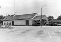
Moncks Corner Railroad Station. View of West (Front) elevation - taken from the NE. Moncks Corner, SC.;6.5" x 9.5" B/W photo. Box 2, Folder 1-8-15. Three copies.
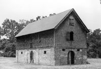
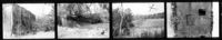
Comingtee Rice Barn (Mill), Located along the Western branch of the Cooper River. Contact Sheet 9 - Multiple Views. Berkeley County, S.C.;6" x 1" B/W photo. Box 20, Folder: Miscellaneous Photos: Scanned Contact Sheets. One copy.
Old Rectory (Gourdin House). Interior View - Detail of Mantle on East Side, 2nd Floor. ENE elevation. Pineville Historic District. St. Stephen, SC.;6.5" x 9.5" B/W photo. Box 3, Folder 1-9-1 (I). One copy.
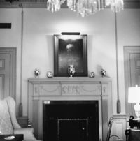
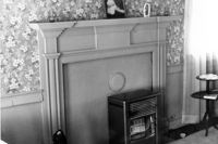
Lawson's Pond Plantation, Lawson Pond Lane. Interior View - Detail of mantle in East Front Room. NW elevation. Cross, SC.;6.5" x 9.5" B/W photo. Box 2, Folder 1-4-3. One copy.