Search
« Previous |
151 - 200 of 5,461
|
Next »
Search Results
Date:
1977-1983
Description:
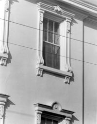
93 Rutledge Avenue, Seabrook-Trenholm House, ca. 1819. Detail View of 2nd Floor windows, East (Front) elevation. 4" x 5" B/W photo.
Date:
1977-1983
Description:
81 Rutledge Avenue, Glover-Sottile House, ca. 1826. Detail View of 1st Floor window, East (Front) elevation. 4" x 5" B/W photo.
Date:
1977-1983
Description:
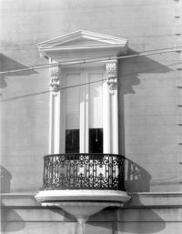
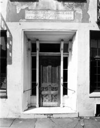
64 South Battery, William Gibbes House, ca. 1772. Main House - Detail View of 1st Floor entry, South (Front) elevation. 4" x 5" B/W photo.
Date:
1977-1983
Description:
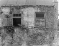
10 Judith Street, John Robinson House, ca. 1814. Kitchen House - Detail View of windows, East (Side) elevation. 4" x 5" B/W photo.
Date:
1977-1983
Description:
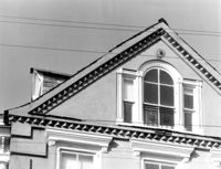
95 Rutledge Avenue, Grimke-Seabrook House, ca. 1819. Detail View of Pediment, East (Front) elevation. 4" x 5" B/W photo.
Date:
1977-1983
Description:
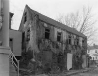
10 Judith Street, John Robinson House, ca. 1814. Kitchen House - View of SE (Rear and Side) elevation. 4" x 5" B/W photo.
Date:
1977-1983
Description:
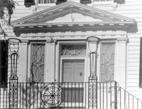
14 George Street, Middleton-Pinckney House, ca. 1796. Detail View of entry, South (Front) elevation. 4" x 5" B/W photo.
Date:
1977-1983
Description:
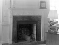
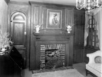
2 - 4 Court House Square, Daniel Blake Tenements, ca. 1760. Interior View - 1st Floor. SW Room - Detail of mantle, West elevation. 4" x 5" B/W photo.
Date:
1977-1983
Description:
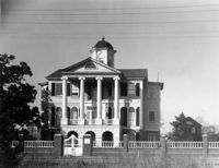
60 - 64 Broad Street, The Confederate Home, ca. 1800. Detail View of main entry, South (Front) elevation. 4" x 5" B/W photo.
Date:
1977-1983
Description:
10 Judith Street, John Robinson House, ca. 1814. Kitchen House - View of North (Side) elevation. 4" x 5" B/W photo.
Date:
1977-1983
Description:
68 Broad Street, Daniel Ravenel House, ca. 1796. Dependency, View of NW (Side and Front) elevation. 4" x 5" B/W photo.
Date:
1863
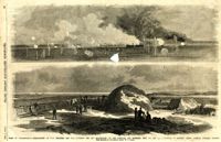
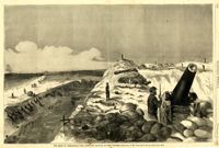
Description:
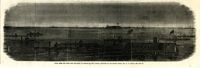
Caption: 'Siege of Charleston--1.Bombardment of Fort Moultrie and the Batteries Bee and Beauregard, by the monitors and ironsides, Sept. 7th and 8th.--2. Interior of Battery Gregg, looking towards Wagner. From sketches by our Special Artist, W.T. Crane.' [full date October 3, 1863.]
Date:
1863
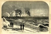
Description:
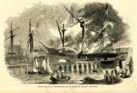
Caption: 'The Siege of Charleston--bombardment of Fort Moultrie by the iron-clads, September 8, 1863.--sketched by Mr. Theodore R. Davis.--[see page 621.] Also identified in the image: Moultrieville, Fort Moultrie and Moultrie House. [full date September 26, 1863.]
Date:
1863
Description:
Caption: 'Night after the fight--the iron clads at anchor off Fort Sumter.--sketched by our Special Artist, Mr. W.T. Crane.--see page 81.' [full date May 2, 1863.]
Date:
1886-1916
Description:
8.4 x 8.5 cm photographic print
Date:
1886-1916
Description:
7.3 x 8.7 cm photographic print
Date:
1865
Description:
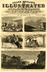
Main caption: 'The present appearance of Charleston, S.C., showing the effects of the Federal bombardment.--from recent sketches by our special artist.' Caption top left: 'Nos.165, 167 and 169 Meeting Street, Charleston, S.C.' Caption top right: 'East Bay Street, looking south.' Caption middle left: 'Kitchen attached to 53 Wentworth Street--effect of two shells.' Caption middle right: 'Gentleman's ordinary, Charleston Hotel.' Caption bottom: 'Vendue Range.' [full date March 25, 1865.]
Date:
1863
Description:
Caption: 'The siege of Charleston--View from the sea-face of Fort Wagner.--sketched by Mr. Theodore R. Davis.--[See Page 621.]' [full date September 26, 1863.]
Date:
1875
Description:
Caption: 'Sketches in Charleston, South Carolina. 1.Cotton Day. 2. A Limb of the Law. 3. Gossips. 4.Light-wood cart. 5. "A Relic". 6. Milk Girl.7. In the Market-Poultry Dealer. 8."Horse" Car.' [full date July 17, 1875.]
Date:
1861
Description:
Caption: 'Scene on the Floating Battery in Charleston Harbor, S.C., during the bombardment of Fort Sumpter (sic).--from a sketch by an Officer.--see page 355.' [full date April 27, 1861.]
Date:
1887
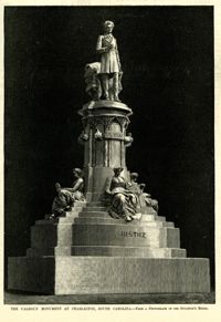
Description:
Caption: 'The Calhoun Monument at Charleston, South Carolina.--from a photograph of the sculptor's model.' [full date March 12, 1887.]
Date:
1887
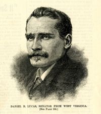
Description:
Caption: 'Daniel B. Lucas, Senator from West Virginia. [See page 183.]' [full date March 12, 1887.]
Date:
1889-1895
Description:
17.9 x 21.8 cm photographic print
Date:
1852
Description:
Caption: 'View of the fire at Charlestown, and the burning of the ship "Bell Rock."' [full date June 19, 1852.]
Date:
1901-1902
Description:
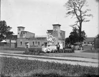
Lighthouse Exibit Near Post Office, South Carolina Interstate and West Indian Exposition
Date:
1901-1902
Description:
Venice in America Restaurant, South Carolina Interstate and West Indian Exposition
Date:
1901-1902
Description:
Louisiana Purchase Exposition Building, South Carolina Interstate and West Indian Exposition
Date:
1901-1902
Description:
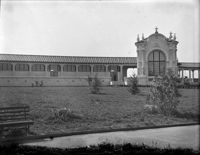
Machinery Hall and Bridge, South Carolina Interstate and West Indian Exposition
Date:
1892-1916
Description:
4.2 x 2.5 cm photographic print
Date:
1977-1983
Description:
64 South Battery, William Gibbes House, ca. 1772. Main House - Interior. 1st Floor - SW Room, Detail of cornice. 4" x 5" B/W photo.
Date:
1977-1983
Description:
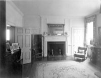
64 South Battery, William Gibbes House, ca. 1772. Main House - Interior. 1st Floor - SE Room, North elevation. 4" x 5" B/W photo.
Date:
1977-1983
Description:
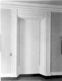
64 South Battery, William Gibbes House, ca. 1772. Main House - Interior. 1st Floor - NW Room, South elevation. 4" x 5" B/W photo.
Date:
1977-1983
Description:
105 Meeting Street, Hibernian Society Hall, ca. 1840. Interior View. Ground Floor - Meeting Room, Detail of window (with shutters closed). 4" x 5" B/W photo.
Date:
1977-1983
Description:
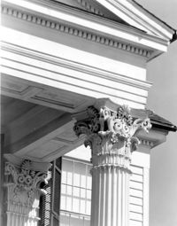
172 Tradd Street, Chisolm-Alston House, ca. 1836. Detail View of portico column, capitals and cornice, South (Front) elevation. 4" x 5" B/W photo.
Date:
1977-1983
Description:
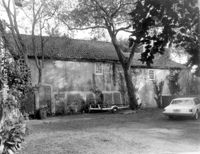
26 South Battery, Colonel John Algernon Sydney Ashe House, ca. 1853. Dependencies - East (Front) elevation. 4" x 5" B/W photo.
Date:
1977-1983
Description:
64 South Battery, William Gibbes House, ca. 1772. Dependency - View of West (Rear) elevation, South end. 4" x 5" B/W photo.
Date:
1977-1983
Description:
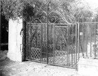
32 South Battery, Colonel John Ashe House, ca. 1762. Main House - Detail View of carriage gates. 4" x 5" B/W photo.
Date:
1977-1983
Description:
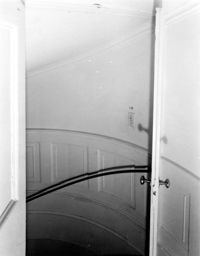
18 Bull Street, William Blacklock House, ca. 1800. Main House - Interior View. 1st Floor - Stair Hall, stairwell. 4" x 5" B/W photo.
Date:
1977-1983
Description:
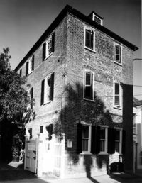
35 Church Street, Young-Johnson House, ca. 1770. View of SE (Front and Side) elevation. 4" x 5" B/W photo.
Date:
1977-1983
Description:
37 Church Street, George Matthews House, ca. 1743. View of SE (Front and Side) elevation. 4" x 5" B/W photo.
Date:
1889-1895
Description:
17.6 x 20.5 cm photographic print
Date:
1977-1983
Description:
39 Church Street, George Everleigh House, ca. 1743. View of South (Front) elevation. 4" x 5" B/W photo.
Date:
circa 1920s-1940s
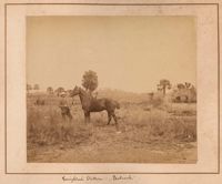
Description:
Unidentified boy dressed in shorts and jacket, sitting on a pony.
Date:
1977-1983
Description:
Charleston County (2695 Laurel Hill Road), Prospect Hill Plantation, ca. 1861. View of NW (Side and Rear) elevation. 4" x 5" B/W photo.
Date:
1977-1983
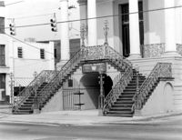
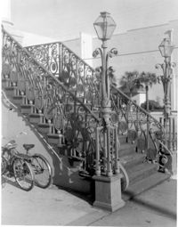
Description:
188 Meeting Street, Market Hall, ca. 1841. Main Hall - Detail View of stairs, SW (Front and Side) elevation. 4" x 5" B/W photo.
Date:
1977-1983
Description:
188 Meeting Street, Market Hall, ca. 1841. Main Hall - Detail View of stairs, West (Front) elevation. 4" x 5" B/W photo.
Date:
1977-1983
Description:
54 Queen Street, Thomas Elfe House, ca. 1760. Interior View - 1st Floor. South Room, East wall. 4" x 5" B/W photo.
Date:
1977-1983
Description:
635 East Bay Street, Faber-Ward House, ca. 1832. Main House and Complex - View of East (Front) elevation 4" x 5" B/W photo.
Date:
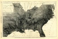
1863
Description:
Caption: 'Map of the Southern states, showing the relative proportion of slaves in the different localities.--[see page 142.]' [full date February 28, 1863.]
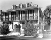
Date:
1977-1983
Description:
56 South Battery, Osborn-McCrady House, ca. 1770. View of South (Front) elevation. 4" x 5" B/W photo.