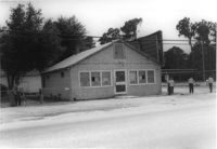
Building (former bar, with Miller High Life signs on windows), on site affected by the widening of State Road 13 (Remount Road). Surveyor notations on back of photo: "Dkt.: 10.562. Property owner: Fannie Lou Owens. Tract: 32. Date: Jul. 12, 1967." [See collection description for explanation of surveyor notations.]
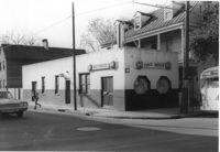
Carl's House (corner view) on site affected by the construction of the Crosstown. Address: 493 Rutledge Avenue. View of street corner. Surveyor notations on back of photo: "Dkt.: 10.524. Property owner: Elise C. Goldberg, et al. Tract: 105. Station: 84+40 Rt. Date: Dec. 1, 1964. In R/W - Bought." [See collection description for explanation of surveyor notations.]
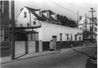
Carl's House (rear and side view) on site affected by the construction of the Crosstown. Address: 493 Rutledge Avenue. Looking towards street corner. Surveyor notations on back of photo: "Dkt.: 10.524. Property owner: Elise C. Goldberg, et al. Tract: 105. Station: 84+40 Rt. Date: Dec. 1, 1964. In R/W - Bought." [See collection description for explanation of surveyor notations.]
Right of way--South Carolina--Charleston County, Highway planning--South Carolina--Charleston County, Commercial buildings--South Carolina--Charleston County, Vernacular architecture--South Carolina--Charleston County, Lost architecture--South Carolina--Charleston County, Bars (Drinking establishments)--South Carolina--Charleston County✖[remove]3
Charleston County (S.C.)--Buildings, structures, etc.✖[remove]3