Wood-sided building on site affected by the construction of Interstate 26 (I-26). Building address number 4804. Neon sign for a Drive In (__MANER'S) (name partly illegible) in front. Billboard for First National Homes (4800 Rivers Ave.) next to building. Possibly on Rivers Avenue. Surveyor notations on back of photo: "Dkt.: 10.486. Property owner: Redding F. Moore. Tract: 23, 24, 25. Station: 15+50 Rt. (Line C). Date: May 30, 1961. In R/W - Bought." [See collection description for explanation of surveyor notations.]
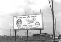
Pure Firebird Gasoline billboard on lot on site affected by the construction of Interstate 26 (I-26). On Meeting Street/Meeting Street Road. Surveyor notations on back of photo: "Dkt.: 10.510. Property owner: Geo. Fabian, Jr. Tract: 67. Station: 5803±50 on CL Line D. Date: Sept. 12, 1962. To be moved by owner." [See collection description for explanation of surveyor notations.]
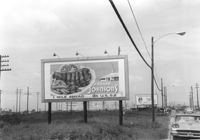
Howard Johnsons billboard on lot on site affected by the construction of Interstate 26 (I-26). Pure Firebird Gasoline billboard in background. On Meeting Street/Meeting Street Road. Surveyor notations on back of photo: "Dkt.: 10.510. Property owner: Geo. Fabian, Jr. Tract: 67. Station: 5805+77 Rt. Line D. Date: Sept. 12, 1962. To be moved by owner." [See collection description for explanation of surveyor notations.]
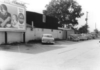
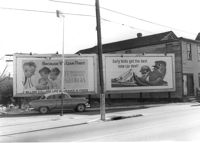
Dorchester Electric Service (side view) on site affected by the construction of Interstate 26 (I-26). Building address number 3640 [possibly Dorchester Road]. Billboard for Swift's Premium Meats for Babies on side of building. Surveyor notations on back of photo: "Dkt.: 10.480. Property owner: Laura B. Beaufort. Tract: 167. Station: 5681+40 Lt. Date: May 30, 1961. In R/W - Bought." [See collection description for explanation of surveyor notations.]
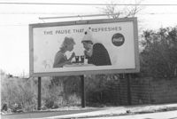
Lot on site affected by the construction of the Crosstown, with billboard for Coca-Cola (The Pause that Refreshes). Address: 67 Lee Street. Surveyor notations on back of photo: "Dkt.: 10.518. Property owner: Edward Washington. Tract: 36. Station: 43+00 Lt. S.B. lane Route 17. Date: Mar. 6, 1963. Sign. [See collection description for explanation of surveyor notations.]
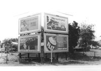
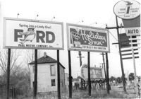
Billboards on lot, on site affected by the construction of Interstate 26 (I-26). Life Insurance Company of Georgia, Sprite, Phillips 66, and FLIT. Surveyor notations on back of photo: "Dkt.: 10.480. Property owner: William C. Minter. Tract: 279. Station: [unknown/unidentified]. Date: May 31, 1961. For information only." [See collection description for explanation of surveyor notations.]
Lot with billboards on site affected by the construction of the Crosstown. Address: 53 Lee Street. Surveyor notations on back of photo: "Dkt.: 10.518. Property owner: Turner Advertising Co. Tract: 50. Station: 46+00 Rt. N.B. lane Route 17. Date: Mar. 6, 1963. In R/W." [See collection description for explanation of surveyor notations.]
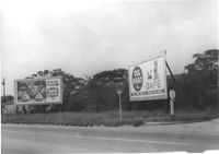
Swift's Ice Cream and "Oil Heat is Safe" billboards on lot on Spruill Avenue at Irving Avenue, on site affected by the construction of Interstate 26 (I-26). Surveyor notations on back of photo: "Dkt.: 10.490. Property owner: Arabelle Simmons, Est. Tract: 28. Date: September 12, 1962. To be moved by owner." [See collection description for explanation of surveyor notations.]
Billboards on lot, on site affected by the construction of the Crosstown. Address: corner of Lee Street and America Street (SW corner). Surveyor notations on back of photo: "Dkt.: 10.518. Property owner: Turner Advertising Co. Tract: 57. Station: 49+30 Rt. S.B. lane Route 17. Date: Mar. 7, 1963. Signs." [See collection description for explanation of surveyor notations.]
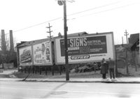
Billboards on lot, on site affected by the construction of the Crosstown. Address: 34-36 Lee Street. Surveyor notations on back of photo: "Dkt.: 10.518. Property owner: Turner Advertising. Tract: 65. Station: 51±45 Rt. & Lt. N.B. lane Route 17. Date: Mar. 7, 1963. Signs. [See collection description for explanation of surveyor notations.]