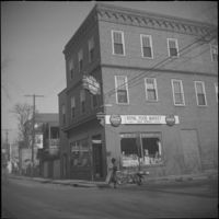
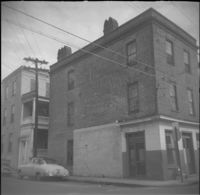
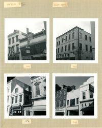
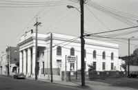
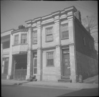
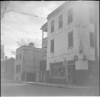
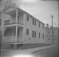
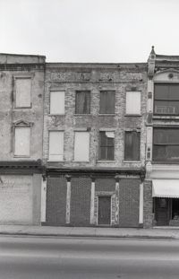
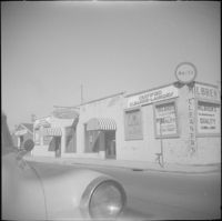
Businesses located at the northeast corner of East Bay Street and Vernon Street: Milbren's Laundry and Dry Cleaning (334 East Bay Street) and Fort Sumter Paper Co. (336 East Bay Street), since demolished.
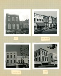
Four B&W photographs of buildings on the east side of King Street: Top left: 220 King Street (Dumas); Top right: 218 King Street (Sharnoff's Uniform Shop); Bottom left (212-218): 212 King Street, 214 King Street (Fabric Center), 216 King Street, and edge of 218 King Street; Bottom right (208-214): 208 King Street (Gatlin Opticians), 212 King Street (La Scaltro Antiques), and 214 King Street (Fabric Center).
Four B&W photographs of buildings on the west side of King Street: Top left (181-183): 181 King Street (Jack Patla Antiques) and 183 King Street (The Art Shop); Top right (175-179): 175 King Street, 177 King Street, and 179 King Street (Fralix & Sons); Bottom left (169-173): 169 King Street (R.M. McGillivray's) and 171-173 King Street; Bottom right (165-169); 165 King Street and 169 King Street (R.M. McGillivray's).
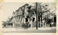
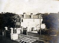
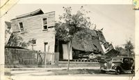
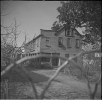
Photograph of a house on Fishburne Street demolished by the tornado of 1938. Neighboring house in view at left. (Both houses would have been on the north side of the 200 block of Fishburne Street.) Handwritten on back of photo: "2nd tornado on Fishburne Street near President Street. Demolished about 60 houses here. This 2nd tornado damage about $6,000,000. 300 houses condemned. Sept. 29, '38."
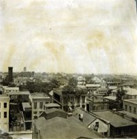
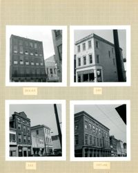
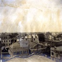
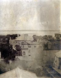
View of Charleston from rooftop in the vicinity of northeast corner of Meeting and Wentworth Streets, facing northeast. Page 4, Photo 2 of collection. 3.5" x 3.5" B/W photograph.
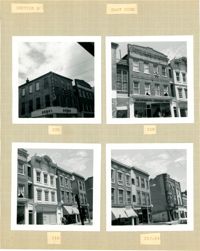
Four B&W photographs of buildings on the east side of King Street: Top left (368-370): 368 King Street (Club 400) (demolished for parking lot) and 270 King Street (World Finance Corp.); Top right: 362-364 King Street (Kaybee); Bottom left (354-356): 354 King Street and 356 King Street (White House Grocery); Bottom right (344-348): 344 King Street (Clark Clothier), 346 King Street, and 348 King Street (American Arcade - American Mortgage Co.)
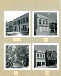
Four B&W photographs of buildings on the west side of King Street, including 213 King and 215 King, demolished for the construction of Majestic Square: Top left (211-215): 211-213 King (Palmetto Hotel) and 215 King Street (Stephan's); Top right: 197 King Street; Bottom left 193-197: 193 King Street (Colonial Antique Shop), 195 King Street, and 197 King Street; Bottom right (191-197): 191 King Street (Birlant Antiques), 193 King Street, 195 King Street, 197 King Street.
Three B&W photographs of buildings on the west side of King Street, demolished for the construction of Majestic Square: Top left: 223 King Street (Ocean Grill); Top right: 221 King Street (photograph is missing); Bottom left (219-223): 219 King Street (Rice Bros.), 221 King Street, and 223 King Street (Ocean Grill); Bottom right (217-219): 217 King Street and 219 King Street (Rice Bros.).
Two B&W photographs of buildings on the east side of King Street, both demolished for the construction of Charleston Place: Left (224-226): 224 King Street and 226 King Street (Ritz Hotel); Right: 222 King Street (Copa Lounge) (northeast corner of King and Market).
Four B&W photographs of buildings on the east side of King Street: Top left (178-184): 178 King Street (W.K. Prause Co.), 180 King Street, 182 King Street, and 184 King Street; Top right: 174 King Street; Bottom left: 164 King Street (Charleston Library Society) [labeled 168 on album page]; Bottom right (160-162): 160 King Street and 162 King Street.
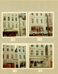
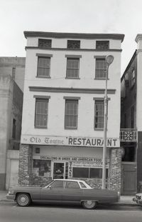
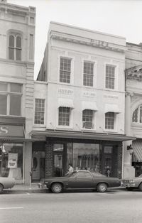
Four color photographs of buildings on the west side of King Street: Top left: 235 King Street (Interiors); Top right: 233 King Street; Bottom left: 231 King Street (The Tiki); Bottom right: 229 King Street (Old Towne Restaurant)
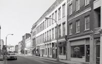
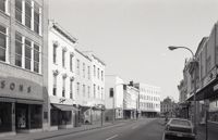
Black-and-white photograph of the view north on King Street showing the east side of King Street from 190 King Street (Home Appliance & Service Co.). Kerrison's building in background.
Black-and-white photograph of the view east on Hasell Street from the C. B. Prentiss & Co. Customer Parking Lot and 95 Hasell Street (St. Mary’s Roman Catholic Church). 87 Hasell and 85 Hasell also in view at left.
Black-and-white photograph of the view from the parking lot of First Citizens Bank (182 Meeting) to the northwest corner of Meeting and Market. South elevation of Market Hall at right.
Black-and-white photograph of the view south on King Street from 260 King Street (Kerrison's building) down to approximately 240 King. Snelgrove’s dress shop (258 King) and Daisy Bogin dress shop (256 King), and the corner of Hasell Street are also in view.
Black-and-white photograph of 254 King Street (Moses Levy Building), southwest corner of building. Signage on building for HFC Loans / Household Finance. Located at the northeast corner of Meeting Street and Hasell Street.
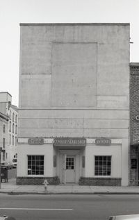
Black-and-white photograph of 252 King Street, street (front) elevation, showing the southeast corner of King Street and Hasell Street. Signage on building for The Connoisseur Shop Interior Design Antiques.
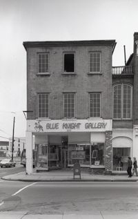
Black-and-white photograph of 220 King Street (Nathan Hart Building), street (front) elevation, with signage for Blue Knight Gallery. Also shows view of street corner (Market Street and King Street).
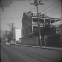
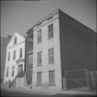
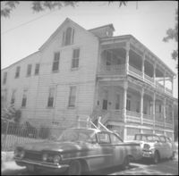
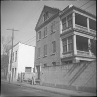
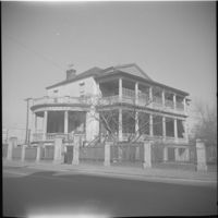
South side of Society street from the corner of Anson Street. Features 49 Society Street (center) and partial views of 60 Anson Street (left edge), 59 Anson Street (Society Street elevation) (adjacent and to the left of 49 Society), and partial view of 51 Society Street (right edge).
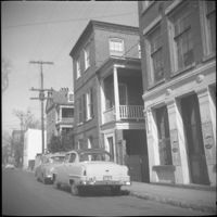
56 Society Street (Dr. Joseph Johnson House). Also in view to the right of 56 Society are 54 Society Street (George Black House) and 52 Society Street (James M. Stocker House).
Photograph of the wreckage of the Calvary Baptist Church, an African-American church demolished by the tornado of September 29, 1938. Located at the corner of Sumter Street and Ashley Avenue; address may have been 387 Sumter Street. Handwritten on back of photo: "Old Negro church on Sumter Street, corner of Ashley Avenue. This was done by second tornado that hit 2 miles from the other one. Sept. 29, 1938."
Photograph of the ruins of a building on King Street after the tornadoes of September 29, 1938. Shows the debris of a completely demolished structure and the damaged roof of the neighboring building. Based on newspaper accounts, this is probably the site of the Rectory of the Church of the Sacred Heart at King and Huger Streets. Three men stand on the sidewalk facing the debris; other men are standing on a pile of debris.
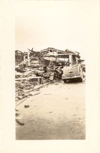
Looking east on Market Street after the tornadoes of September 29, 1938, showing the Market Sheds in ruins. A damaged car is parked along side of the debris. The Old Church of the Redeemer can be seen in the background.
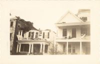
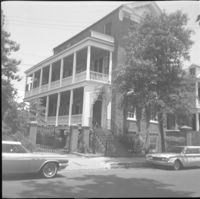
Photograph of 38 South Battery and 40 South Battery [Frederick Heinz Houses] and a portion of 42 South Battery, after the tornadoes of September 29, 1938, showing the damage done to the houses.
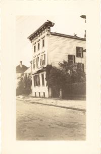
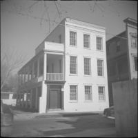
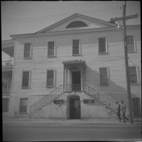
Photograph 19 King Street [Thomas Lamboll House] after the tornadoes of September 29, 1938, showing the damage done to the house. King Street elevation.
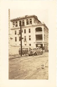
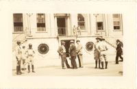
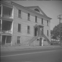
Photograph of the Timrod Hotel [ca. 101 Meeting Street], after the tornadoes of September 29, 1938, showing the damage done to the building. View of the hotel looking north on Meeting Street (southeast elevation). Infantry patrolmen stand on sidewalk by a car. Signage for Byars Drug Store is on the south elevation. [Note: The hotel was later demolished in the 1960s.]
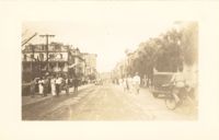
Photograph of Broad Street, looking east at the 60 block, showing the scene on the street after the tornadoes of September 29, 1938. The Daniel Ravenel House (68 Broad Street), the Confederate Home, and the People's Building can be seen at the right; the Old Exchange Building is visible in the background. Onlookers, cars, and a person riding a bicycle are on the street.
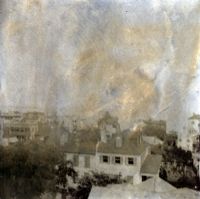
View of Charleston from rooftop at northeast corner of Wentworth and Meeting Streets, facing northwest. Page 22, Photo 2 of collection. 3.5" x 3.5" B/W photograph.
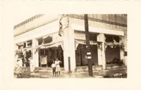
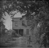
Photograph showing several dwellings in Fiddlers Green damaged or destroyed by the tornado of 1938. Handwritten on back of photo: "1st tornado hit Fiddlers Green, Negro section by Ashley Bridge, Hilly Street [should be Lilly Street], Sept. 29, '38."
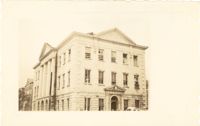
Photograph of the Charleston County Courthouse after the tornadoes of September 29, 1938, showing the damage done to the building. View of the corner elevation (Meeting Street and Broad Street). People who are standing inside the building at the second and third story windows can be seen. To the left of the Courthouse, the Hebrew Orphanage (88 Broad Street) is also in view.
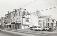
Photograph of a commercial building on a Church Street corner after the tornadoes of September 29, 1938, showing the damage done to the building. Probably located at the corner of Church and North Market Street or South Market Street. Onlookers stand on sidewalk.
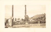
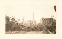
Photograph of Washington Square Park after the tornadoes of September 29, 1938, showing debris and fallen trees in the foreground; Washington Light Infantry monument in the middle; and the Meeting Street fire tower and Chalmers Street buildings in the background.
Photograph of City Hall after the tornadoes of September 29, 1938, showing the damage done to the building. Infantry patrolmen and other men stand in front of building.
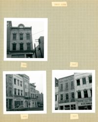
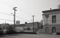
Black-and-white photograph of the east side of the 240 block of Meeting Street, from a parking lot at the corner of Meeting and Hasell Streets and showing 246 Meeting Street (Anderson Electric Co.). 248 Meeting, 250 Meeting, and 252 Meeting. Southwest elevations of 66 Hasell Street and 64 Hasell Street visible at right. (246-250 Meeting is currently a parking lot.)
Black-and-white photograph of the northwest elevation of 235 Meeting Street. Shows the corner of Meeting and Hasell Streets and the north elevation of the building that extends west on Hasell Street. "Picture Framing" signage over window. Also shows neighboring buildings to the south in the view down Meeting. (Currently the site of Sticky Fingers Restaurant.)
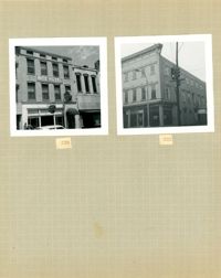
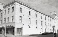
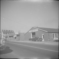
Black-and-white photograph of the Heart of Charleston Motor Hotel at 200 Meeting Street, between Hayne Street and Pinckney Street. Corner view of building (northeast elevation) and view of the southeast corner of Meeting and Pinckney. (Previously the site of The Charleston Hotel (1838-1960) and currently the site of the Bank of America Building.)
Black-and-white photograph of Market Hall (188 Meeting Street) and the view east on South Market Street showing the Market sheds. Corner of North Market Street also in view.

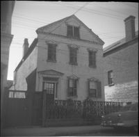
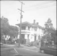
![116 Anson Street [now at 39 Laurens Street]](https://iiif.library.cofc.edu/iiif/2/48431/full/200,/0/default.jpg)