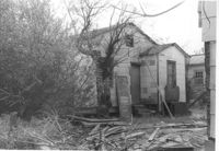
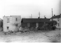
House on Spruill Avenue (rear view) on site affected by the construction of Interstate 26 (I-26). Surveyor notations on back of photo: "Dkt.: 10.490. Property owner: Julia M. Pritchard. Tract: 28-B. Station: 49+20 Rt. (Spruill Ave.) Date: November 4, 1965. Rear view of residence that is partially in R/W. Range poles on new R/W." [See collection description for explanation of surveyor notations.]
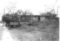
House on Spruill Avenue on site affected by the construction of Interstate 26 (I-26). Surveyor notations on back of photo: "Dkt.: 10.490. Property owner: Julia M. Pritchard. Tract: 28-B. Station: 48+80 Rt. (Spruill Ave.) Date: November 4, 1965. South side of residence that is partially in R/W. Range poles on new R/W." [See collection description for explanation of surveyor notations.]
House on Spruill Avenue on site affected by the construction of Interstate 26 (I-26). [Intersection of Hugo Avenue.] Surveyor notations on back of photo: "Dkt.: 10.490. Property owner: Julia M. Pritchard. Tract: 28-B. Station: 48+80 Rt. (Spruill Ave.) Date: November 4, 1965. Range poles on new R/W. Building partially in R/W." [See collection description for explanation of surveyor notations.]
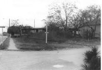
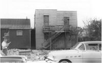
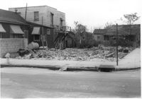
Lot on Spruill Avenue at intersection of Hugo Avenue, on site affected by the construction of Interstate 26 (I-26). View of street corner. House in photo 1103 in background. Surveyor notations on back of photo: "Dkt.: 10.490. Property owner: Bunch Realty Co. Tract: 28-D. Station: 48+00 Rt. (Spruill Ave.) Date: November 4, 1965. Take includes entire lot. Range poles on new R/W." [See collection description for explanation of surveyor notations.]
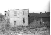
House on site affected by the construction of the Crosstown. On Cooper Street; address unknown. Surveyor notations on back of photo: "Dkt.: 10.518. Property owner: Louise McLead Drayton. Tract: 30-B. Station: 14+60 Lt. (Cooper Street). 41+70 Rt. (U.S. Rt. 17). Date: Apr. 20, 1965. Partially in R/W." [See collection description for explanation of surveyor notations.]
House (side view) on site affected by the construction of the Crosstown. On Cooper Street; address unknown. Surveyor notations on back of photo: "Dkt.: 10.518. Property owner: Louise McLead Drayton. Tract: 30-B. Station: 14+60 Lt. (Cooper Street). 41+70 Rt. (U.S. Rt. 17). Date: Apr. 20, 1965. Partially in R/W." [See collection description for explanation of surveyor notations.]
House (side view) on site affected by the construction of the Crosstown. On Cooper Street; address unknown. Surveyor notations on back of photo: "Dkt.: 10.518. Property owner: Louise McLead Drayton. Tract: 30-B. Station: 14+60 Lt. (Cooper Street). 41+70 Rt. (U.S. Rt. 17). Date: Apr. 20, 1965. Partially in R/W." [See collection description for explanation of surveyor notations.]
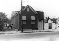
House (corner view, street elevation) and lot on site affected by the construction of the Crosstown. On Cooper Street; address unknown. View of street corner. Surveyor notations on back of photo: "Dkt.: 10.518. Property owner: Louise McLead Drayton. Tract: 30-B. Station: 14+60 Lt. (Cooper Street). 41+70 Rt. (U.S. Rt. 17). Date: Apr. 20, 1965. Partially in R/W." [See collection description for explanation of surveyor notations.]
House (side view) on site affected by the construction of the Crosstown. On Cooper Street; address unknown. Surveyor notations on back of photo: "Dkt.: 10.518. Property owner: Louise McLead Drayton. Tract: 30-B. Station: 14+60 Lt. (Cooper Street). 41+70 Rt. (U.S. Rt. 17). Date: Apr. 20, 1965. Partially in R/W." [See collection description for explanation of surveyor notations.]
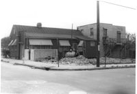
Lot and house on corner, on site affected by the construction of the Crosstown. On Cooper Street; address unknown. View of street corner. Surveyor notations on back of photo: "Dkt.: 10.518. Property owner: Louise McLead Drayton. Tract: 30-B. Station: 14+60 Lt. (Cooper Street). 41+70 Rt. (U.S. Rt. 17). Date: Apr. 20, 1965. Partially in R/W." [See collection description for explanation of surveyor notations.]
Right of way--South Carolina--Charleston County, Highway planning--South Carolina--Charleston County, Vernacular architecture--South Carolina--Charleston County, Lost architecture--South Carolina--Charleston County, Dwellings--South Carolina--Charleston County✖[remove]58