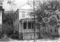
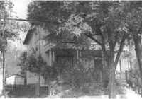
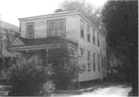
House on site affected by the construction of Interstate 26 (I-26). Address: 82 Fishburne Street. Surveyor notations on back of photo: "Dkt.: 10.517. Property owner: Ernest And Mabel Garner. Tract: 125. Station: 23+75 Lt. & Rt. (Line "1" survey). Date: November 4, 1965. Subject building and entire lot entirely in R/W. Bought." [See collection description for explanation of surveyor notations.]
House (side view towards rear) on site affected by the construction of Interstate 26 (I-26). Address: 82 Fishburne Street. Surveyor notations on back of photo: "Dkt.: 10.517. Property owner: Ernest And Mabel Garner. Tract: 125. Station: 23+50 Rt. (Line "1" survey). Date: November 4, 1965. Side view of subject building entirely in R/W. Bought." [See collection description for explanation of surveyor notations.]
House (front and side view) on site affected by the construction of Interstate 26 (I-26). (Presumably where the Crosstown is today or the vicinity.) Address number 82. Surveyor notations on back of photo: "Dkt.: 10.517. Property owner: Ernest And Mabel Garner. Tract: 125. Station: 23+75 Rt. (Line "1" survey). Date: November 4, 1965. Side view of subject building entirely in R/W. Bought." [See collection description for explanation of surveyor notations.]
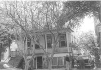
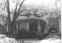
House on site affected by the construction of Interstate 26 (I-26). Address: 84 Fishburne Street. Surveyor notations on back of photo: "Dkt.: 10.517. Property owner: Miss Fannie A. Patrick. Tract: 126. Station: 23+50 Rt. (Line "1" survey). Date: November 4, 1965. Subject building and lot entirely in R/W. Condemned." [See collection description for explanation of surveyor notations.]
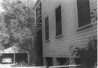
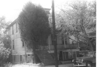
House (front and side view) on site affected by the construction of Interstate 26 (I-26). Address: 84 Fishburne Street. Surveyor notations on back of photo: "Dkt.: 10.517. Property owner: Miss Fannie A. Patrick. Tract: 126. Station: 23+50 Rt. (Line "1" survey). Date: November 4, 1965. Side view of building and showing garage in rear, all in R/W. Condemned." [See collection description for explanation of surveyor notations.]
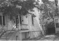
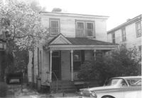
House on site affected by the construction of Interstate 26 (I-26). Address: 7 Carolina Street. Surveyor notations on back of photo: "Dkt.: 10.517. Property owner: Carrie M. Leaphart. Tract: 127. Station: 22+20 Rt. (Line "1" survey). Date: November 4, 1965. Front view of residence. Entire building and lot in R/W." [See collection description for explanation of surveyor notations.]
House (front and side view) on site affected by the construction of Interstate 26 (I-26). Address: 7 Carolina Street. Surveyor notations on back of photo: "Dkt.: 10.517. Property owner: Carrie M. Leaphart. Tract: 127. Station: 22+20 Rt. (Line "1"). Date: November 4, 1965. Side view of building and lot that is entirely in R/W." [See collection description for explanation of surveyor notations.]
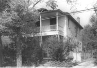
House on site affected by the construction of Interstate 26 (I-26). Address: 5 Carolina Street. Surveyor notations on back of photo: "Dkt.: 10.517. Property owner: I.S. Keith Ellsworth, Sr. Tract: 128. Station: 22+00 Rt. (Line "1"). Date: November 4, 1965. Front and side view of residence and property entirely in R/W." [See collection description for explanation of surveyor notations.]
House on site affected by the construction of Interstate 26 (I-26). Address: 5 Carolina Street. Surveyor notations on back of photo: "Dkt.: 10.517. Property owner: I.S. Keith Ellsworth, Sr. Tract: 128. Station: 22+00 Rt. (Line "1"). Date: November 4, 1965. View of subject building and lot entirely in R/W." [See collection description for explanation of surveyor notations.]
House on site affected by the construction of Interstate 26 (I-26). Address: 3 Carolina Street. Surveyor notations on back of photo: "Dkt.: 10.517. Property owner: Benjamin J. Finklea. Tract: 129. Station: 21+65 Rt. (Line "1"). Date: November 4, 1965. Subject residence and lot entirely in R/W." [See collection description for explanation of surveyor notations.]
Right of way--South Carolina--Charleston County, Highway planning--South Carolina--Charleston County, Vernacular architecture--South Carolina--Charleston County, Lost architecture--South Carolina--Charleston County, Dwellings--South Carolina--Charleston County✖[remove]58