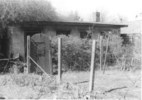
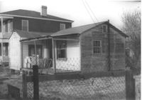
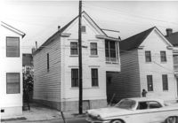
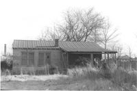
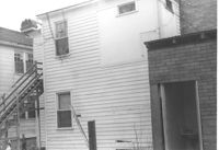
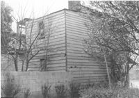
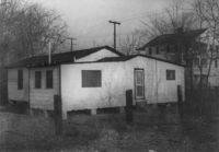
Backyard and structure on site affected by the construction of Interstate 26 (I-26). Address: 1201 King Street. Surveyor notations on back of photo: "Dkt.: 10.503. Property owner: Gladys Hardy. Tract: 18. Station: 5895+00 Rt. Date: Feb. 19, 1963. In R/W - Bought." [See collection description for explanation of surveyor notations.]
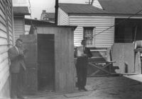
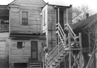
House (rear view) on site affected by the construction of the Crosstown. Address: 72 Cooper Street. Outhouse in foreground. Surveyor notations on back of photo: "Dkt.: 10.518. Property owner: Otis Williams. Tract: 22. Station: 40+55 Rt. N.B. lane Route 17. Date: Mar. 6, 1963." [See collection description for explanation of surveyor notations.]
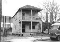
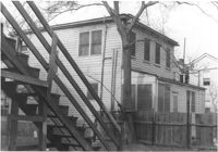
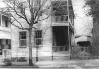
House on site affected by the construction of Interstate 26 (I-26). Address: 79 Cooper Street. Surveyor notations on back of photo: "Dkt.: 10.517. Property owner: John D. Bendt Jr. Tract: 69. Station: 5959+00 Rt. - Line 4. Date: March 5, 1963. In R/W - Bought." [See collection description for explanation of surveyor notations.]
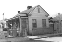
House on St. Phillip Street at the corner of Sheppard Street, on site affected by the construction of Interstate 26 (I-26). Address: 270 St. Philip Street. Surveyor notations on back of photo: "Dkt.: 10.517. Property owner: Hattie Givens. Tract: 90. Station: 24+80 Lt. Northbound Lane Route 17. Date: March 5, 1963. In R/W - Bought." [See collection description for explanation of surveyor notations.]
House (rear view) on site affected by the construction of the Crosstown. Address: 118 America Street. Surveyor notations on back of photo: "Dkt.: 10.518. Property owner: Thelma Brown. Tract: 61. Station: 50+75 Rt. N.B. lane Route 17. Date: Mar. 7, 1963. In R/W - Bought." [See collection description for explanation of surveyor notations.]
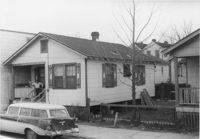
House on site affected by the construction of the Crosstown. Address: 122 America Street. Surveyor notations on back of photo: "Dkt.: 10.518. Property owner: H.B. Lasaine, et al. Tract: 63. Station: 50+70 Lt. N.B. lane Route 17. Date: Mar. 7, 1963. In R/W - Bought." [See collection description for explanation of surveyor notations.]
House on site affected by the construction of the Crosstown. Address: 118 America Street. Surveyor notations on back of photo: "Dkt.: 10.518. Property owner: Thelma Brown. Tract: 61. Station: 50+75 Rt. N.B. lane Route 17. Date: Mar. 7, 1963. In R/W - Bought." [See collection description for explanation of surveyor notations.]
Billboards on lot, on site affected by the construction of the Crosstown. Address: 34-36 Lee Street. Surveyor notations on back of photo: "Dkt.: 10.518. Property owner: Turner Advertising. Tract: 65. Station: 51±45 Rt. & Lt. N.B. lane Route 17. Date: Mar. 7, 1963. Signs. [See collection description for explanation of surveyor notations.]
House (rear view) on site affected by the construction of Interstate 26 (I-26). Address: 83 Fishburne Street. Surveyor notations on back of photo: "Dkt.: 10.517. Property owner: Georgette H. Gilchrist. Tract: 108. Station: 23+75 Lt. Southbound Lane Route 17. Date: March 5, 1963. In R/W - Bought." [See collection description for explanation of surveyor notations.]
House (corner view, rear) on site affected by the construction of Interstate 26 (I-26). Address: 3 A Street (now 3 Walnut Street). Surveyor notations on back of photo: "Dkt.: 10.517. Property owner: Theresa H. Walker. Tract: 48. Station: 5952+70 Lt. - Line 6. Date: February 21, 1963. In R/W - Bought." [See collection description for explanation of surveyor notations.]
House (corner view, rear) on site affected by the construction of Interstate 26 (I-26). Address: 1 A Street (now 11 Walnut Street). Surveyor notations on back of photo: "Dkt.: 10.517. Property owner: Theresa H. Walker. Tract: 49. Station: 5953+15 Lt. - Line 6. Date: February 21, 1963. In R/W - Bought." [See collection description for explanation of surveyor notations.]
House on site affected by the construction of Interstate 26 (I-26). Address: 7½ A Street (now 7½ Walnut Street), at corner of C Street. Surveyor notations on back of photo: "Dkt.: 10.517. Property owner: H.B. Hogg, Est. Tract: 47. Station: 5951+85 Rt. - Line 6. Date: February 21, 1963. In R/W - Bought." [See collection description for explanation of surveyor notations.]
House on site affected by the construction of Interstate 26 (I-26). Address: 92 Lee Street (rear). Surveyor notations on back of photo: "Dkt.: 10.517. Property owner: Robert L. Chamberlain, et al. Tract: 51. Station: 5953+60 CL - Line 6. Date: February 21, 1963. In R/W - Bought." [See collection description for explanation of surveyor notations.]
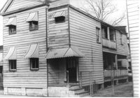
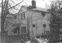
House (rear view) on site affected by the construction of the Crosstown. Address: 176 Nassau Street. Surveyor notations on back of photo: "Dkt.: 10.518. Property owner: Carole B. Priester. Tract: 32. Station: 42+35 Lt. N.B. lane Route 17. Date: Mar. 6, 1963. In R/W - Bought. [See collection description for explanation of surveyor notations.]
House (rear view) on site affected by the construction of the Crosstown. Address: 176 Nassau Street. Surveyor notations on back of photo: "Dkt.: 10.518. Property owner: Carole B. Priester. Tract: 32. Station: 42+05 Lt. N.B. lane Route 17. Date: Mar. 6, 1963. In R/W - Bought. [See collection description for explanation of surveyor notations.]
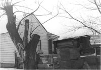
House (rear view) on site affected by the construction of the Crosstown. Address: 61 Lee Street. Surveyor notations on back of photo: "Dkt.: 10.518. Property owner: Sabrina Frost, Est. Tract: 39. Station: 44+00 CL S.B. lane Route 17. Date: Mar. 6, 1963. In R/W - Bought. [See collection description for explanation of surveyor notations.]
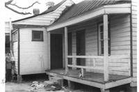
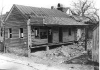
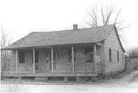
Freedman's cottage on site affected by the construction of the Crosstown. Address: 169 Nassau Street. Surveyor notations on back of photo: "Dkt.: 10.518. Property owner: R.F. Momier. Tract: 23. Station: 40+85 Rt. N.B. lane Route 17. Date: Mar. 6, 1963. In R/W - Bought. [See collection description for explanation of surveyor notations.]
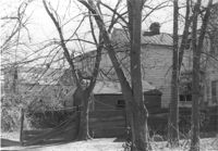
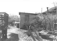
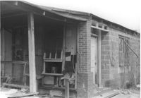
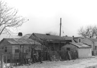
"Junk lot" behind houses on site affected by the construction of the Crosstown. Address: 171 Nassau Street. Surveyor notations on back of photo: "Dkt.: 10.518. Property owner: Samuel J. Lloyd. Tract: 24. Station: 40+70 CL N.B. lane Route 17. Date: Mar. 6, 1963. In R/W - Bought. [See collection description for explanation of surveyor notations.]
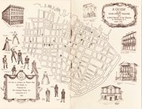
This illustrated pamphlet gives a brief history of the Dock Street Theatre in Charleston, South Carolina and provides rich physical details about the building, including photographs, floor plans and cross sections. Also included is a list of historic personalities identified with Charleston theatres and major theatrical events in city history. The front and back covers unfold into a map of peninsular Charleston showing the locales of past and current theatres (guide to map on page 14). 15 pages. Full text.
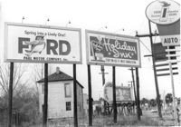
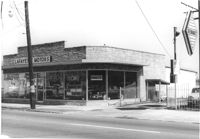
Lafayette Motors, on site affected by the construction of Interstate 26 (I-26). Address: 680 King Street. Surveyor notations on back of photo: "Dkt.: 10.517. Property owner: Raymond A. Wittschen. Tract: 122. Station: 28+35 Lt. Southbound Lane Route 17. Date: March 5, 1963. Proximity." [See collection description for explanation of surveyor notations.]
House on Coming Street near the corner of Sheppard Street, on site affected by the construction of Interstate 26 (I-26). Address: 278 Coming Street. Surveyor notations on back of photo: "Dkt.: 10.517. Property owner: Isaac Perry, et al. Tract: 99. Station: 22+00 Rt. Northbound Lane Route 17. Date: March 5, 1963. In R/W - Bought." [See collection description for explanation of surveyor notations.]
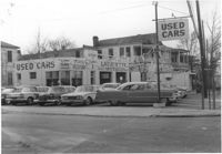
Lafayette Motors (Used Cars), on site affected by the construction of Interstate 26 (I-26). Address: 683 King Street. View of street corner (King Street and Fishburne Street. Surveyor notations on back of photo: "Dkt.: 10.517. Property owner: Hewitt Oil Co. Tract: 118. Station: 27+09 Lt. Southbound Lane Route 17. Date: March 5, 1963. Proximity." [See collection description for explanation of surveyor notations.]
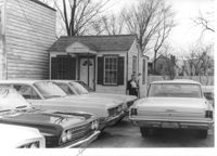
Small office structure, with parked cars in foreground, on site affected by the construction of Interstate 26 (I-26). Address: 665 King Street. Surveyor notations on back of photo: "Dkt.: 10.517. Property owner: Palace Realty Co. Tract: 81. Station: 27±00 Rt. Northbound Lane Route 17. Date: March 5, 1963. In R/W - Bought." [See collection description for explanation of surveyor notations.]
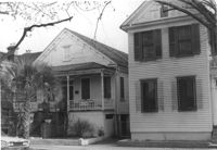
Houses near the corner of Sheppard Street, on site affected by the construction of Interstate 26 (I-26). Addresses: 280 Coming Street (L) and 278 Coming Street (R). Surveyor notations on back of photo: "Dkt.: 10.517. Property owner: Jessica P. Brown. Tract: 98. Station: 22+00 Rt. Northbound Lane Route 17. Date: March 5, 1963. In R/W - Bought." [See collection description for explanation of surveyor notations.]
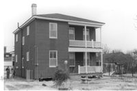
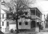
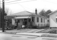
House (corner view, piazza side) on site affected by the construction of Interstate 26 (I-26). Address: 286 Coming Street. Surveyor notations on back of photo: "Dkt.: 10.517. Property owner: Wilhelmina J. Fields, Est. Tract: 104. Station: 22+60 Lt. Southbound Lane Route 17. Date: March 5, 1963. In R/W - Bought." [See collection description for explanation of surveyor notations.]
House (freedman's cottage) (rear view) on site affected by the construction of Interstate 26 (I-26). Address: 20 C Street. (1951 Sanborn map indicates the address is 14 C Street.) Surveyor notations on back of photo: "Dkt.: 10.517. Property owner: Edward Gallashaw, et al. Tract: 31. Station: 5948+50 Lt. - Line 6. Date: February 21, 1963. In R/W - Bought." [See collection description for explanation of surveyor notations.]
House in dilapidated condition (freedman's cottage?) on site affected by the construction of Interstate 26 (I-26). Address: 6 C Street. Number 14 painted on brick by front door. Surveyor notations on back of photo: "Dkt.: 10.517. Property owner: Mary Wayman. Tract: 30. Station: 5948+20 Lt. - Line 6. Date: February 21, 1963. In R/W - Bought." [See collection description for explanation of surveyor notations.]
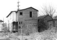
Structure in grassy lot, that looks like a dwelling but has Body Shop painted on side of building, on site affected by the construction of Interstate 26 (I-26). Address: 91 Lee Street (rear). Surveyor notations on back of photo: "Dkt.: 10.517. Property owner: W.H. Yon. Tract: 56. Station: 34+40 Rt. - Route 17. Date: February 21, 1963." [See collection description for explanation of surveyor notations.]
House (corner view, rear) on site affected by the construction of Interstate 26 (I-26). Address: 69 Fishburne Street. Surveyor notations on back of photo: "Dkt.: 10.517. Property owner: Ben F. Yancy, et al. Tract: 116. Station: 26+30 CL Southbound Lane Route 17. Date: March 5, 1963. In R/W - Bought." [See collection description for explanation of surveyor notations.]
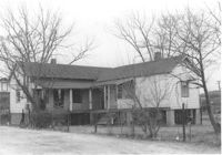
House on site affected by the construction of Interstate 26 (I-26). Address: 85 Fishburne Street and its neighbor, 87 Fishburne Street. Surveyor notations on back of photo: "Dkt.: 10.517. Property owner: Thelma G. Carter. Tract: 107. Station: 23+30 Lt. Southbound Lane Route 17. Date: March 5, 1963. In R/W - Bought." [See collection description for explanation of surveyor notations.]
House near the corner of Sheppard Street, on site affected by the construction of Interstate 26 (I-26). Address: 280 Coming Street. Surveyor notations on back of photo: "Dkt.: 10.517. Property owner: Jessica P. Brown. Tract: 98. Station: 22+00 Rt. Northbound Lane Route 17. Date: March 5, 1963. In R/W - Bought." [See collection description for explanation of surveyor notations.]
House (rear view) on site affected by the construction of Interstate 26 (I-26). Address: 270 St. Philip Street. Surveyor notations on back of photo: "Dkt.: 10.517. Property owner: William H. Steedley. Tract: 114. Station: 25+40 Rt. Southbound Lane Route 17. Date: March 5, 1963. In R/W - Bought." [See collection description for explanation of surveyor notations.]
House on site affected by the construction of Interstate 26 (I-26). Address: 284 Coming Street. Surveyor notations on back of photo: "Dkt.: 10.517. Property owner: M.J. Christine Butt, Est. Tract: 103. Station: 22+40 Rt. Southbound Lane Route 17. Date: March 5, 1963. In R/W - Bought." [See collection description for explanation of surveyor notations.]
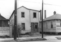
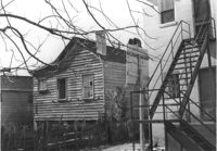
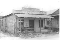
Dilapidated structure (possibly had commercial use) on site affected by the construction of Interstate 26 (I-26). Address: 3 C Street. "Saw Filing" sign posted on rail. Front facade has stepped parapet. Surveyor notations on back of photo: "Dkt.: 10.517. Property owner: J.W. Prescott. Tract: 43. Station: 5950+60 CL Line 2. Date: February 21, 1963. In R/W - Bought." [See collection description for explanation of surveyor notations.]
Dilapidated dwelling on site affected by the construction of Interstate 26 (I-26).Address: 6 D Street. Surveyor notations on back of photo: "Dkt.: 10.517. Property owner: Lawrence Felder, et al., Est. Tract: 15. Station: 5945+60 Lt. Date: February 21, 1963. In R/W - Bought." [See collection description for explanation of surveyor notations.]
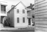
House (rear view) on site affected by the construction of Interstate 26 (I-26). Address: 18 D Street. Surveyor notations on back of photo: "Dkt.: 10.517. Property owner: Annie Marie Brown. Tract: 7. Station: 5944+15 CL - Line 6. Date: February 21, 1963. In R/W - Bought." [See collection description for explanation of surveyor notations.]
Dwelling on site affected by the construction of Interstate 26 (I-26). Address: 3 C Street. Surveyor notations on back of photo: "Dkt.: 10.517. Property owner: J.W. Prescott. Tract: 43. Station: 5950+60 CL Line 2. Date: February 21, 1963. In R/W - Bought." [See collection description for explanation of surveyor notations.]
House on site affected by the construction of Interstate 26 (I-26). Address: 1 C Street. Surveyor notations on back of photo: "Dkt.: 10.517. Property owner: Ernie C. Swack. Tract: 44. Station: 5951+10 Lt. - Line 2. Date: February 21, 1963. In R/W - Bought." [See collection description for explanation of surveyor notations.]
Dilapidated structure (rear view) on site affected by the construction of Interstate 26 (I-26). Address: 3 C Street. Surveyor notations on back of photo: "Dkt.: 10.517. Property owner: J.W. Prescott. Tract: 43. Station: 5950+60 CL - Line 2. Date: February 21, 1963. In R/W - Bought." [See collection description for explanation of surveyor notations.]
House in dilapidated condition (freedman's cottage) on site affected by the construction of Interstate 26 (I-26). Address: 22 Poinsett Street. Surveyor notations on back of photo: "Dkt.: 10.503. Property owner: Emma J. Marjen Hoff, Est. Tract: 103. Station: 5921+70 CL. Date: Feb. 20, 1963. In R/W - Bought." [See collection description for explanation of surveyor notations.]
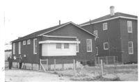
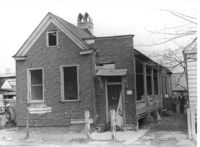
Free Kindergarten (corner view, rear) on site affected by the construction of Interstate 26 (I-26). Address: 20 Huger Street. Surveyor notations on back of photo: "Dkt.: 10.503. Property owner: Free Kindergarten Assoc. of Chas. Tract: 113. Station: 5936+50 Rt. CL. Date: Feb. 20, 1963. In R/W - Bought." [See collection description for explanation of surveyor notations.]
Lot (and rear view of neighboring houses and structures) on site affected by the construction of Interstate 26 (I-26). Address: 26 Addison Street. Surveyor notations on back of photo: "Dkt.: 10.503. Property owner: Alice Campbell Johnson. Tract: 96. Station: 5919+00 Rt. Date: Feb. 20, 1963. In R/W - Bought." [See collection description for explanation of surveyor notations.]
House (freedman's cottage) and shed (rear view) on site affected by the construction of Interstate 26 (I-26). Address: 24 Addison Street. Surveyor notations on back of photo: "Dkt.: 10.503. Property owner: Beatrice Scott. Tract: 93. Station: 5918+80 CL. Date: Feb. 20, 1963. In R/W - Bought." [See collection description for explanation of surveyor notations.]
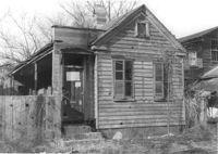
House (freedman's cottage) on site affected by the construction of Interstate 26 (I-26). Address: 7 Brigade Street. Surveyor notations on back of photo: "Dkt.: 10.503. Property owner: Idella C. Calvin. Tract: 45. Station: 5905+20 Lt. Date: Feb. 19, 1963. In R/W - Bought." [See collection description for explanation of surveyor notations.]
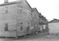
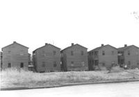
Row of houses (rear view) on site affected by the construction of Interstate 26 (I-26). Address: 16-18 J Place [between Lenox and Brigade]. (See Sheet 1 of 1951 Sanborn Map.) Surveyor notations on back of photo: "Dkt.: 10.503. Property owner: Gussie Feldman. Tract: 41. Station: 5903+50 Rt. & Lt. In R/W - Bought." [See collection description for explanation of surveyor notations.]
Row of houses on Brigade Street, on site affected by the construction of Interstate 26 (I-26). Address: 10-18 J Place [between Lenox and Brigade]. (See Sheet 1 of 1951 Sanborn Map.) Surveyor notations on back of photo: "Dkt.: 10.503. Property owner: Gussie Feldman. Tract: 41. Station: 5903+50 Rt. & Lt. In R/W - Bought." [See collection description for explanation of surveyor notations.]
House (rear view) on site by the construction of Interstate 26 (I-26). Address: 1211 King Street. Surveyor notations on back of photo: "Dkt.: 10.503. Property owner: Albert M. Jones, et al. Tract: 17. Station: 5895+00 Lt. Date: Feb. 19, 1963. In R/W - Bought." [See collection description for explanation of surveyor notations.]
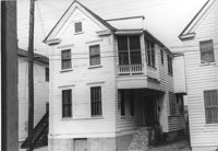
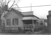
House on site by the construction of Interstate 26 (I-26). Address: 1213 King Street. Surveyor notations on back of photo: "Dkt.: 10.503. Property owner: Robert C. Benke, et al. Tract: 16. Station: 5894+90 Lt. Date: Feb. 19, 1963. In R/W - Bought." [See collection description for explanation of surveyor notations.]
House on site by the construction of Interstate 26 (I-26). Address: 1211 King Street. Surveyor notations on back of photo: "Dkt.: 10.503. Property owner: Albert M. Jones, et al. Tract: 17. Station: 5895+00 Lt. Date: Feb. 19, 1963. In R/W - Bought." [See collection description for explanation of surveyor notations.]