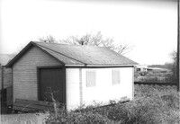
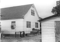
Shed (railroad building) on site affected by the construction of Interstate 26 (I-26). Address: 19½ Poinsett Street (rear). Surveyor notations on back of photo: "Dkt.: 10.503. Property owner: S.A.L.R.R. Tract: 105. Station: 5924+25 Rt. Date: Feb. 20, 1963." [See collection description for explanation of surveyor notations.]
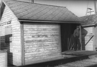
Shed (railroad building) along railroad tracks, on site affected by the construction of Interstate 26 (I-26). Address: 19½ Poinsett Street (rear). Surveyor notations on back of photo: "Dkt.: 10.503. Property owner: S.A.L.R.R. Tract: 105. Station: 5924+40 Lt. Date: Feb. 20, 1963." [See collection description for explanation of surveyor notations.]
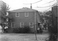
Dwelling (rear view) on site affected by the construction of Interstate 26 (I-26). Address: 39-43 Mount Pleasant Street. Surveyor notations on back of photo: "Dkt.: 10.503. Property owner: Mary Ellen Long Way. Tract: 4. Station: 5891+80 Lt. Date: Feb. 19, 1963. In R/W - Bought." [See collection description for explanation of surveyor notations.]
House (rear view) on site affected by the construction of Interstate 26 (I-26). Address: 166-168 Laurel Avenue. Surveyor notations on back of photo: "Dkt.: 10.503. Property owner: J.W. Johnson, Jr. Tract: 10. Station: 5894+00 Rt. Date: Feb. 19, 1963. In R/W - Bought." [See collection description for explanation of surveyor notations.]
House (rear view) on site affected by the construction of Interstate 26 (I-26). Address: 162 Laurel Avenue. Surveyor notations on back of photo: "Dkt.: 10.503. Property owner: David E. O'Brien. Tract: 9. Station: 5894+15 Rt. Date: Feb. 19, 1963. In R/W - Bought." [See collection description for explanation of surveyor notations.]
House (rear view) on site affected by the construction of Interstate 26 (I-26). Address: 164 Laurel Avenue. Surveyor notations on back of photo: "Dkt.: 10.503. Property owner: J.W. Johnson, Jr. Tract: 10. Station: 5894+00 Rt. Date: Feb. 19, 1963. In R/W - Bought." [See collection description for explanation of surveyor notations.]
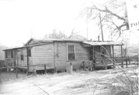
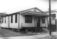
House on site affected by the construction of Interstate 26 (I-26). Address: 169 Laurel Avenue. Surveyor notations on back of photo: "Dkt.: 10.503. Property owner: Ernestine L. Captain. Tract: 5. Station: 5892+10 Rt. Date: Feb. 19, 1963. In R/W - Bought." [See collection description for explanation of surveyor notations.]
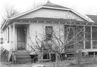
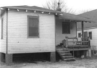
Dilapidated dwelling (corner view, rear) on site affected by the construction of Interstate 26 (I-26). Address; 19½ Poinsett Street. Surveyor notations on back of photo: "Dkt.: 10.503. Property owner: S.A.L.R.R. Tract: 105. Station: 5922+65 CL. Date: Feb. 20, 1963. In R/W - Bought." [See collection description for explanation of surveyor notations.]
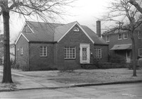
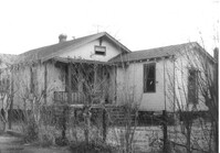
House on site affected by the construction of Interstate 26 (I-26). Address: 92 Lee Street. Surveyor notations on back of photo: "Dkt.: 10.517. Property owner: Robert L. Chamberlain, et al. Tract: 51. Station: 5954+15 CL - Line 5. Date: February 21, 1963. In R/W - Bought." [See collection description for explanation of surveyor notations.]
House (rear view) on site affected by the construction of Interstate 26 (I-26). Address: 96 Lee Street. Surveyor notations on back of photo: "Dkt.: 10.517. Property owner: Maude D. Scott. Tract: 53. Station: 5954+00 CL. Date: February 21, 1963. In R/W - Bought." [See collection description for explanation of surveyor notations.]