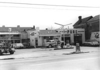
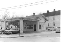
Pure Gas Station: and neighboring house, on site affected by the construction of the Crosstown. Address: 522 Meeting Street. Surveyor notations on back of photo: "Dkt.: 10.518. Property owner: Pure Oil Co. Tract: 1. Station: 38+40 on CL S.B. lane Route 17. Date: Mar. 6, 1963. In R/W - Bought. [See collection description for explanation of surveyor notations.]
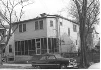
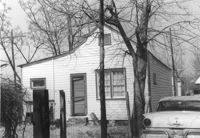
House (review view) on site affected by the construction of the Crosstown. Address: 76 Cooper Street. Surveyor notations on back of photo: "Dkt.: 10.518. Property owner: Lewis Rosen. Tract: 11. Station: 5965+10 CL Line 3, S.B. lane Route 17. Date: Mar. 6, 1963. In R/W - Bought. [See collection description for explanation of surveyor notations.]
Houses on site affected by the construction of the Crosstown. Address: 74½ Cooper Street [74 Cooper Street]. Surveyor notations on back of photo: "Dkt.: 10.518. Property owner: Beatrice Hayward. Tract: 12. Station: 5965+30 Rt. Line 3, S.B. lane of Route 17. Date: Mar. 6, 1963. In R/W - Bought. [See collection description for explanation of surveyor notations.]
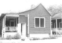
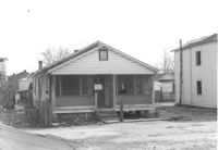
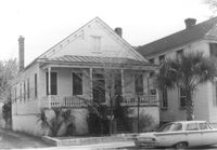
Street corner and houses on site affected by the construction of the Crosstown. Address: 100 Sheppard Street. Surveyor notations on back of photo: "Dkt.: 10.518. Property owner: M.J. Christine Butt, Est. Tract: 19. Station: 29+40 Lt. Sheppard Street. Date: Mar. 6, 1963. In R/W - Bought. [See collection description for explanation of surveyor notations.]
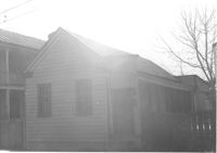
Building that may have previously been a gas station, on site affected by the construction of Interstate 26 (I-26). Address: 669 King Street. "No Money Down" painted on front window. Surveyor notations on back of photo: "Dkt.: 10.517. Property owner: The Texas Co. Tract: 83. Station: 27+40 Rt. Northbound Lane Route 17. Date: March 5, 1963. In R/W - Bought." [See collection description for explanation of surveyor notations.]
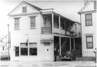
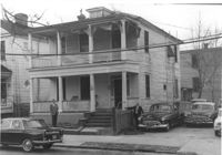
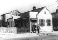
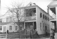
Building with ground-story business, Sunset Memorial Gardens, and second-story residence, on site affected by the construction of Interstate 26 (I-26). Address: 642 King Street. Surveyor notations on back of photo: "Dkt.: 10.517. Property owner: N.W. Cabell. Tract: 80. 29+00 Rt. Northbound Lane. Date: March 5, 1963. In R/W - Bought." [See collection description for explanation of surveyor notations.]
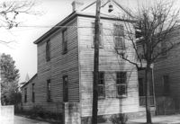
House (corner view, rear) on site affected by the construction of Interstate 26 (I-26). Address: 268 St. Philip Street. Surveyor notations on back of photo: "Dkt.: 10.517. Property owner: Sara Fox. Tract: 113. Station: 25+20 Rt. Southbound Lane Route 17. Date: March 5, 1963. In R/W - Bought." [See collection description for explanation of surveyor notations.]
House on site affected by the construction of Interstate 26 (I-26). Address: 270 St. Philip Street. Surveyor notations on back of photo: "Dkt.: 10.517. Property owner: William H. Steedley. Tract: 114. Station: 25+40 Rt. Southbound Lane Route 17. Date: March 5, 1963. In R/W - Bought." [See collection description for explanation of surveyor notations.]
House on site affected by the construction of Interstate 26 (I-26). Address: 69 Fishburne Street. Surveyor notations on back of photo: "Dkt.: 10.517. Property owner: Ben F. Yancy, et al. Tract: 116. Station: 26+30 CL Southbound Lane Route 17. Date: March 5, 1963. In R/W - Bought." [See collection description for explanation of surveyor notations.]
House on site affected by the construction of Interstate 26 (I-26). Address: 68 Fishburne Street. Surveyor notations on back of photo: "Dkt.: 10.517. Property owner: Annie F. Moessner. Tract: 117. Station: 26+55 Lt. Southbound Lane Route 17. Date: March 5, 1963. Proximity." [See collection description for explanation of surveyor notations.]
House (corner view, rear) on site affected by the construction of Interstate 26 (I-26). 7 Wood Street. Surveyor notations on back of photo: "Dkt.: 10.503. Property owner: Janie Washington. Tract: 34. Station: 5901+00 Lt. Date: Feb. 19, 1963. In R/W - Bought." [See collection description for explanation of surveyor notations.]
House (freedman's cottage) on site affected by the construction of Interstate 26 (I-26). Address: 19 Riker Street. (1951 Sanborn map indicates the address is 20 Riker Street.) Surveyor notations on back of photo: "Dkt.: 10.503. Property owner: E.L. Geunveur. Tract: 69. Station: 5911+40 Rt. & Lt. CL. Date: Feb. 20, 1963. In R/W - Bought." [See collection description for explanation of surveyor notations.]
House (freedman's cottage) on site affected by the construction of Interstate 26 (I-26). Address: 24 Riker Street. Surveyor notations on back of photo: "Dkt.: 10.503. Property owner: Ethel Middleton. Tract: 65. Station: 5910+55 Rt. Date: May 30, 1963. In R/W - Bought." [See collection description for explanation of surveyor notations.]
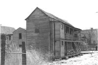
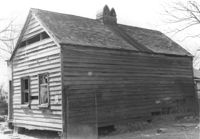
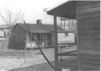
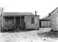
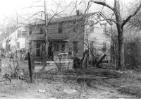
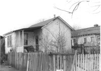
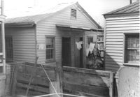
House (freedman's cottage) in dilapidated condition (rear view) on site affected by the construction of Interstate 26 (I-26). Address: 107½ Romney Street [107 Romney Street]. Surveyor notations on back of photo: "Dkt.: 10.503. Property owner: Louise W. Vaughan. Tract: 91. Station: 5916+40 on CL. Date: Feb. 20, 1963. In R/W - Bought." [See collection description for explanation of surveyor notations.]
House (rear view) on site affected by the construction of Interstate 26 (I-26). Address: 19 Riker Street. (1951 Sanborn map indicates the address is 20 Riker Street.) Surveyor notations on back of photo: "Dkt.: 10.503. Property owner: E.L. Geunveur. Tract: 69. Station: 5911+40 Rt. & Lt. CL. Date: Feb. 20, 1963. In R/W - Bought." [See collection description for explanation of surveyor notations.]
House on site affected by the construction of Interstate 26 (I-26). Address: 14 Wood Street. Surveyor notations on back of photo: "Dkt.: 10.503. Property owner: Walter K. Brown. Tract: 32. Station: 5900+10 Lt. Date: Feb. 19, 1963. In R/W - Bought." [See collection description for explanation of surveyor notations.]
House on site affected by the construction of Interstate 26 (I-26). Address: 9 Wood Street. Surveyor notations on back of photo: "Dkt.: 10.503. Property owner: Janie Washington. Tract: 34. Station: 5901+00 Lt. Date: Feb. 19, 1963. In R/W - Bought." [See collection description for explanation of surveyor notations.]
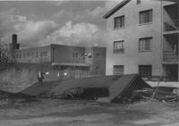
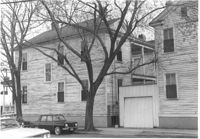
Construction debris and neighboring buildings on site affected by the construction of Interstate 26 (I-26). Address: 1220 King Street. Coca Cola Bottling Co. building (1129 Meeting Street) in background. Surveyor notations on back of photo: "Dkt.: 10.503. Property owner: House of God. Tract: 31. Station: 5900+30 Lt. Date: Feb. 19, 1963. In R/W - Bought." [See collection description for explanation of surveyor notations.]
House (rear view) on site affected by the construction of the Crosstown. Address: 20 Cooper Street (based on 1951 Sanborn Map, perhaps behind 22 Cooper Street). Elevated roadway (presumably the off-ramp of the Grace Memorial Bridge) in background. Surveyor notations on back of photo: "Dkt.: 10.518. Property owner: Toots Brown. Tract: 79. Station: 54+25 Rt. N.B. lane Route 17. Date: Mar. 7, 1963. In R/W - Bought." [See collection description for explanation of surveyor notations.]
House (freedman's cottage) on site affected by the construction of the Crosstown. Address: 28 Lee Street (28 1/3 Lee Street). Porch of neighboring house in foreground. Surveyor notations on back of photo: "Dkt.: 10.518. Property owner: Sara Johnson, et al. Tract: 81. Station: 53+45 Rt. N.B. lane Route 17. Date: Mar. 7, 1963." [See collection description for explanation of surveyor notations.]
House (freedman's cottage) on site affected by the construction of the Crosstown. Address: 2 Lee Street. Surveyor notations on back of photo: "Dkt.: 10.518. Property owner: Kate R. Rosen. Tract: 71. Station: 30+00 Rt. Lee St. survey. 53+30 CL N.B. lane Rt. 17. Date: Mar. 7, 1963. In R/W - Bought." [See collection description for explanation of surveyor notations.]
House (rear view) on site affected by the construction of Interstate 26 (I-26).Address: 7 D Street. Surveyor notations on back of photo: "Dkt.: 10.517. Property owner: Rebecca Finklestein. Tract: 16. Station: 5945+45 Lt. - Line 1. Date: February 21, 1963. In R/W - Bought." [See collection description for explanation of surveyor notations.]
House (freedman's cottage) on site affected by the construction of Interstate 26 (I-26). Address: 102 Romney Street. Surveyor notations on back of photo: "Dkt.: 10.503. Property owner: Mary G. Dawson. Tract: 86. Station: 5915+60 Lt. Date: Feb. 20, 1963. In R/W - Bought." [See collection description for explanation of surveyor notations.]
House (freedman's cottage) (rear view) on site affected by the construction of Interstate 26 (I-26). Address: 102 Romney Street. Surveyor notations on back of photo: "Dkt.: 10.503. Property owner: Mary G. Dawson. Tract: 86. Station: 5915+60 Lt. Date: Feb. 20, 1963. In R/W - Bought." [See collection description for explanation of surveyor notations.]
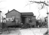
House (rear view) on site affected by the construction of Interstate 26 (I-26). Address: 9 Boyer Street. Surveyor notations on back of photo: "Dkt.: 10.503. Property owner: Atlantic Coast Life Ins. Co. Tract: 85. Station: 5914+95 Lt. Date: Feb. 20, 1963. In R/W - Bought." [See collection description for explanation of surveyor notations.]
House (freedman's cottage?) (rear view) on site affected by the construction of Interstate 26 (I-26). Address: 21 Addison Street. Surveyor notations on back of photo: "Dkt.: 10.503. Property owner: Andrew R. Bland. Tract: 97. Station: 5919+90 Rt. Date: Feb. 20, 1963. In R/W - Bought." [See collection description for explanation of surveyor notations.]
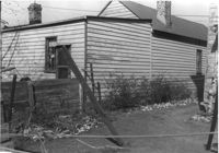
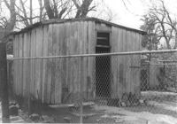
Shed or garage on site affected by the construction of Interstate 26 (I-26). Address: 17 Addison Street. Surveyor notations on back of photo: "Dkt.: 10.503. Property owner: Violet Chapman. Tract: 99. Station: 5920+70 Lt. Date: Feb. 20, 1963. In R/W - Bought." [See collection description for explanation of surveyor notations.]
House (corner view, rear) on street corner, on site affected by the construction of Interstate 26 (I-26). Address: 681 King Street. Surveyor notations on back of photo: "Dkt.: 10.517. Property owner: H.H. Rabens. Tract: 119 & 120. Station: 27+00 Rt. Southbound Lane Route 17. Date: March 5, 1963. In R/W - Bought." [See collection description for explanation of surveyor notations.]
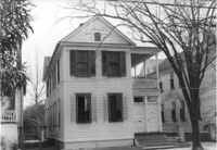
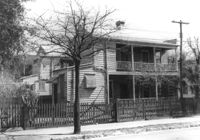
House (corner view) on site affected by the construction of Interstate 26 (I-26). Address: 284 Coming Street. Surveyor notations on back of photo: "Dkt.: 10.517. Property owner: M.J. Christine Butt, Est. Tract: 103. Station: 22+40 Rt. Southbound Lane Route 17. Date: March 5, 1963. In R/W - Bought." [See collection description for explanation of surveyor notations.]
House on site affected by the construction of Interstate 26 (I-26). Address: 87 Fishburne Street (and 87A Fishburne Street). Surveyor notations on back of photo: "Dkt.: 10.517. Property owner: Mona G. Sokol. Tract: 106. Station: 23+00 Lt. Southbound Lane Route 17. Date: March 5, 1963. In R/W - Bought." [See collection description for explanation of surveyor notations.]
House on site affected by the construction of Interstate 26 (I-26). Address: 87 Fishburne Street (and 87A Fishburne Street). Surveyor notations on back of photo: "Dkt.: 10.517. Property owner: Mona G. Sokol. Tract: 106. Station: 23+00 Lt. Southbound Lane Route 17. Date: March 5, 1963. In R/W - Bought." [See collection description for explanation of surveyor notations.]
House on site affected by the construction of Interstate 26 (I-26). Address: 91 Fishburne Street. Surveyor notations on back of photo: "Dkt.: 10.517. Property owner: Annie E. Stossen. Tract: 105. Station: 22+65 Lt. Southbound Lane Route 17. Date: March 5, 1963. In R/W - Bought." [See collection description for explanation of surveyor notations.]
House on site affected by the construction of Interstate 26 (I-26). Address: 85 Fishburne Street. Surveyor notations on back of photo: "Dkt.: 10.517. Property owner: Thelma G. Carter. Tract: 107. Station: 23+30 Lt. Southbound Lane Route 17. Date: March 5, 1963. In R/W - Bought." [See collection description for explanation of surveyor notations.]
House (rear view) on site affected by the construction of Interstate 26 (I-26). Address: 19 Addison Street. Surveyor notations on back of photo: "Dkt.: 10.503. Property owner: Ida Tobias Jackson. Tract: 98. Station: 5920+50 CL on Lt. Date: Feb. 20, 1963. In R/W - Bought." [See collection description for explanation of surveyor notations.]
House on St. Phillip Street at the corner of Sheppard Street (corner view, rear, Sheppard Street side), on site affected by the construction of Interstate 26 (I-26). Address: 277 St. Philip Street. View of Street corner. Surveyor notations on back of photo: "Dkt.: 10.517. Property owner: George A. Castens. Tract: 93. Station: 24+00 Lt. Northbound Lane Route 17. Date: March 5, 1963. In R/W - Bought." [See collection description for explanation of surveyor notations.]
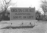
Sign for Orvin Court (Plantation) on lot, dwellings in background, on site affected by the construction of Interstate 26 (I-26). Address: 1204 King Street. Surveyor notations on back of photo: "Dkt.: 10.503. Property owner: Francis Hartnett. Tract: 24. Station: 5896+50 Lt. Date: Feb. 19, 1963. In R/W - Bought." [See collection description for explanation of surveyor notations.]
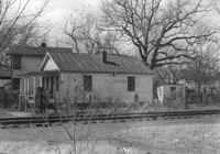
House (side view) on site affected by the construction of Interstate 26 (I-26). Address: 26 Sans Souci Street. Railroad tracks in foreground. Surveyor notations on back of photo: "Dkt.: 10.503. Property owner: Annie E. Koger. Tract: 26. Station: 5898+85 Rt. Date: Feb. 19, 1963. In R/W - Bought." [See collection description for explanation of surveyor notations.]
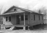
House (rear view) on site affected by the construction of Interstate 26 (I-26). Address: 87 Sheppard Street. Surveyor notations on back of photo: "Dkt.: 10.517. Property owner: Elsie B. Mappus. Tract: 87. Station: 26+00 CL Northbound Lane - Route 17. Date: March 5, 1963. In R/W - Bought." [See collection description for explanation of surveyor notations.]
House on site affected by the construction of the Crosstown. Address: 57 Lee Street. Surveyor notations on back of photo: "Dkt.: 10.518. Property owner: Augustus G. Purvis. Tract: 49. Station: 45+05 Lt. N.B. lane Route 17. Date: Mar. 6, 1963. In R/W - Bought." [See collection description for explanation of surveyor notations.]
House on site affected by the construction of the Crosstown. Address: 55 Lee Street. Surveyor notations on back of photo: "Dkt.: 10.518. Property owner: Augustus G. Purvis. Tract: 49. Station: 45+55 Lt. N.B. lane Route 17. Date: Mar. 6, 1963. In R/W - Bought." [See collection description for explanation of surveyor notations.]
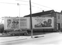
Lot with billboards on site affected by the construction of the Crosstown. Address: 53 Lee Street. Surveyor notations on back of photo: "Dkt.: 10.518. Property owner: Turner Advertising Co. Tract: 50. Station: 46+00 Rt. N.B. lane Route 17. Date: Mar. 6, 1963. In R/W." [See collection description for explanation of surveyor notations.]
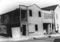
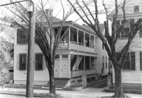
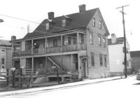
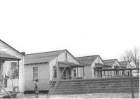
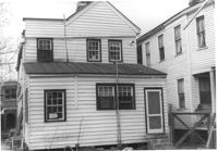
Lot with five dwellings, on site affected by the construction of Interstate 26 (I-26). Address 13-27 C Street. Appears to be a multi-family residence. Surveyor notations on back of photo: "Dkt.: 10.517. Property owner: J.W.C. Bischoff. Tract: 36, 37, 38, 39 & 40. Station: 5948+00 - 5949+70 Rt. & Lt. Date: February 21, 1963. In R/W - Bought." [See collection description for explanation of surveyor notations.]
House (freedman's cottage?) on site affected by the construction of Interstate 26 (I-26). Address: 7 C Street. Surveyor notations on back of photo: "Dkt.: 10.517. Property owner: Cora G. Kelly, Est. Tract: 41. Station: 5950+00 Lt. Line 2. Date: February 21, 1963. In R/W - Bought." [See collection description for explanation of surveyor notations.]
House (rear view) on site affected by the construction of Interstate 26 (I-26). Address: 89 Sheppard Street. Surveyor notations on back of photo: "Dkt.: 10.517. Property owner: Cecil Taylor, et al. Tract: 88. Station: 25+75 Lt. Northbound Lane - Route 17. Date: March 5, 1963. In R/W - Bought." [See collection description for explanation of surveyor notations.]
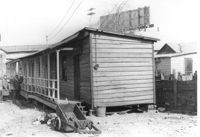
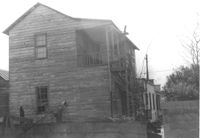
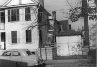
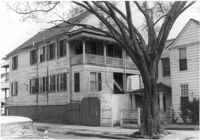
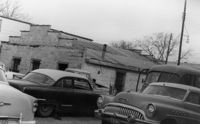
One-story building (rear view) and back lot on site affected by the construction of Interstate 26 (I-26). Address: 75 Cooper Street. Rear facade has stepped parapet. Several cars in back lot. Surveyor notations on back of photo: "Dkt.: 10.517. Property owner: S.E. Jenkins. Tract: 71. Station: 5959+75 CL - Line 4. Date: March 5, 1963. In R/W - Bought." [See collection description for explanation of surveyor notations.]
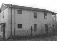
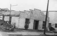
One-story building on site affected by the construction of Interstate 26 (I-26). Address: 75 Cooper Street. Front facade has stepped parapet. Sign for chain saws over doorway. Surveyor notations on back of photo: "Dkt.: 10.517. Property owner: S.E. Jenkins. Tract: 71. Station: 5959+75 CL - Line 4. Date: March 5, 1963. In R/W - Bought." [See collection description for explanation of surveyor notations.]
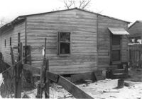
Freedman's cottage on site affected by the construction of the Crosstown. Address: 74½ Cooper Street [74 Cooper Street]. Surveyor notations on back of photo: "Dkt.: 10.518. Property owner: R.F. Momier. Tract: 23. Station: 40+45 Rt. N.B. lane Route 17. Date: Mar. 6, 1963. In R/W - Bought. [See collection description for explanation of surveyor notations.]
House on site affected by the construction of the Crosstown. Address: 100 Sheppard Street. Surveyor notations on back of photo: "Dkt.: 10.518. Property owner: M.J. Christine Butt, Est. Tract: 19. Station: 29+40 to 29+75 Lt. Sheppard Street. Date: Mar. 6, 1963. In R/W - Bought. [See collection description for explanation of surveyor notations.]
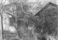
House (rear view) and structure (obscured by trees) on site affected by the construction of Interstate 26 (I-26). Address: 1200 King Street. Surveyor notations on back of photo: "Dkt.: 10.503. Property owner: William R. Nelson. Tract: 22. Station: 5897+40 Rt. Date: Feb. 19, 1963. In R/W - Bought." [See collection description for explanation of surveyor notations.]
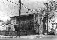
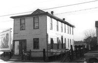
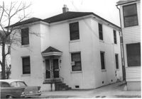
House (duplex) on site affected by the construction of Interstate 26 (I-26). Address: 103A-103B Sheppard Street. (1951 Sanborn map indicates the address is 99 Sheppard Street.) Surveyor notations on back of photo: "Dkt.: 10.517. Property owner: Hyman Karesh, Est. Tract: 97. Station: 22+35 CL Northbound Lane Route 17. Date: March 5, 1963. In R/W - Bought." [See collection description for explanation of surveyor notations.]