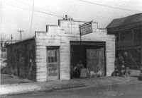
Building -- Simmons Garage -- on site affected by the construction of the Crosstown. Address: 76 Cooper Street or 78 Cooper Street. Front facade has stepped parapet. Surveyor notations on back of photo: "Dkt.: 10.518. Property owner: Helen Phillips Brown. Tract: 10. Station: 39+30 Rt. North Bound Survey of Route 17. Date: Mar. 6, 1963. In R/W - Bought. [See collection description for explanation of surveyor notations.]
Rear view of building -- Simmons Garage -- on site affected by the construction of the Crosstown. Address: 76 Cooper Street or 78 Cooper Street. Surveyor notations on back of photo: "Dkt.: 10.518. Property owner: Helen Phillips Brown. Tract: 10. Station: 39+30 Rt. North Bound Route 17 Lane. Date: Mar. 6, 1963. In R/W - Bought. [See collection description for explanation of surveyor notations.]
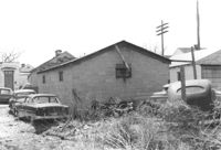
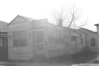
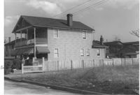
House-like structure (rear view) and neighboring structures on site affected by the construction of Interstate 26 (I-26). Address: 739 Meeting Street. Surveyor notations on back of photo: "Dkt.: 10.503. Property owner: George E. Williams. Tract: 60. Station: 5909+30 Rt. Date: Feb. 20, 1963. In R/W - Bought." [See collection description for explanation of surveyor notations.]
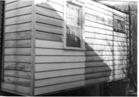
Exterior wall of freedman's cottage on site affected by the construction of Interstate 26 (I-26). Address: 23 Riker Street. Surveyor notations on back of photo: "Dkt.: 10.503. Property owner: Lucille Williams. Tract: 68. Station: 5911+35 Rt. Date: Feb. 20, 1963. In R/W - Bought." [See collection description for explanation of surveyor notations.]
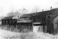
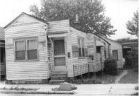
House (freedman's cottage) on site affected by the construction of Interstate 26 (I-26). Address: 23 Riker Street. Surveyor notations on back of photo: "Dkt.: 10.503. Property owner: Lucille Williams. Tract: 68. Station: 5911+35 Rt. Date: Feb. 20, 1963. In R/W - Bought." [See collection description for explanation of surveyor notations.]
House (freedman's cottage) on site affected by the construction of Interstate 26 (I-26). Address: 23 Riker Street. Surveyor notations on back of photo: "Dkt.: 10.503. Property owner: Lucille Williams. Tract: 68. Station: 5911+40 Rt. Date: May 30, 1963. In R/W - Bought." [See collection description for explanation of surveyor notations.]
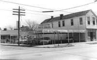
Corner of Meeting Street and Cooper Street. Charleston Auto Sales (510 Meeting Street) and Infinger's Shoe Store (508 Meeting Street), on site affected by the construction of the Crosstown. Surveyor notations on back of photo: "Dkt.: 10.518. Property owner: Robert L. Knoth. Tract: 14. Station: 5962+85 CL of Line 3 of the S.B. lane of Route 17. Date: Mar. 6, 1963. In R/W - Bought. [See collection description for explanation of surveyor notations.]
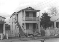
House on site affected by the construction of Interstate 26 (I-26). Address: 10 Lenox Street. Surveyor notations on back of photo: "Dkt.: 10.503. Property owner: Benjamin Thompson. Tract: 37. Station: 5901+50 Lt. Date: Feb. 19, 1963. In R/W - Bought." [See collection description for explanation of surveyor notations.]
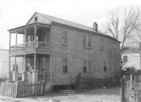
House on site affected by the construction of Interstate 26 (I-26). Address: 5 Lenox Street. Surveyor notations on back of photo: "Dkt.: 10.503. Property owner: Estelle Thompson. Tract: 40. Station: 5902+60 Lt. Date: Feb. 19, 1963. In R/W - Bought." [See collection description for explanation of surveyor notations.]
House on site affected by the construction of Interstate 26 (I-26). Address: 14 Lenox street. Surveyor notations on back of photo: "Dkt.: 10.503. Property owner: Harry Thompson. Tract: 38. Station: 5901+50 Rt. Date: Feb. 19, 1963. In R/W - Bought." [See collection description for explanation of surveyor notations.]