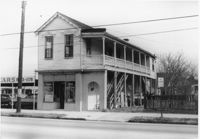
Infinger's Shoe Service on site affected by the construction of Interstate 26 (I-26). Address: 508 Meeting Street. Surveyor notations on back of photo: "Dkt.: 10.517. Property owner: Pandora Co. Tract: 63. Station: 5963+00 CL - Line 6. Date: March 5, 1963. Partially in R/W." [See collection description for explanation of surveyor notations.]
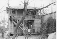
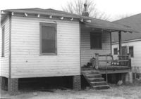
House (rear view) on site affected by the construction of Interstate 26 (I-26). Address: 86 Cooper Street. Surveyor notations on back of photo: "Dkt.: 10.517. Property owner: Nellie T. France. Tract: 62. Station: 5961+60 Rt. - Line 6. Date: March 5, 1963. In R/W - Bought." [See collection description for explanation of surveyor notations.]
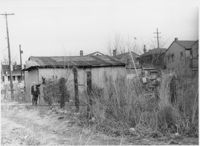
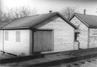
Wooden structure (shed or garage?) (rear view) on site affected by the construction of Interstate 26 (I-26). Address: 23 Jacobs Court. Surveyor notations on back of photo: "Dkt.: 10.517. Property owner: Furman G. Owens. Tract: 60-B. Station: 40+00 Lt. Northbound Lane, 5960+40 Lt. - Line 6. Date: March 5, 1963. In R/W - Bought." [See collection description for explanation of surveyor notations.]
House (side view) on site affected by the construction of Interstate 26 (I-26). Address: 15 Addison Street (rear). Surveyor notations on back of photo: "Dkt.: 10.503. Property owner: Maggie Tobias. Tract: 100-A. Station: 5920+45 Lt. Date: Feb. 20, 1963. Outside R/W bought." [See collection description for explanation of surveyor notations.]
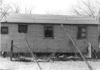
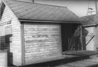
Shed (railroad building) along railroad tracks, on site affected by the construction of Interstate 26 (I-26). Address: 19½ Poinsett Street (rear). Surveyor notations on back of photo: "Dkt.: 10.503. Property owner: S.A.L.R.R. Tract: 105. Station: 5924+35 Rt. & Lt. Date: Feb. 20, 1963." [See collection description for explanation of surveyor notations.]
Shed (railroad building) on site affected by the construction of Interstate 26 (I-26). Address: 19½ Poinsett Street (rear). Surveyor notations on back of photo: "Dkt.: 10.503. Property owner: S.A.L.R.R. Tract: 105. Station: 5924+25 Rt. Date: Feb. 20, 1963." [See collection description for explanation of surveyor notations.]
Shed (railroad building) along railroad tracks, on site affected by the construction of Interstate 26 (I-26). Address: 19½ Poinsett Street (rear). Surveyor notations on back of photo: "Dkt.: 10.503. Property owner: S.A.L.R.R. Tract: 105. Station: 5924+40 Lt. Date: Feb. 20, 1963." [See collection description for explanation of surveyor notations.]
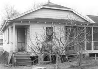
Dwelling (rear view) on site affected by the construction of Interstate 26 (I-26). Address: 39-43 Mount Pleasant Street. Surveyor notations on back of photo: "Dkt.: 10.503. Property owner: Mary Ellen Long Way. Tract: 4. Station: 5891+80 Lt. Date: Feb. 19, 1963. In R/W - Bought." [See collection description for explanation of surveyor notations.]
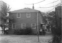
House (rear view) on site affected by the construction of Interstate 26 (I-26). Address: 166-168 Laurel Avenue. Surveyor notations on back of photo: "Dkt.: 10.503. Property owner: J.W. Johnson, Jr. Tract: 10. Station: 5894+00 Rt. Date: Feb. 19, 1963. In R/W - Bought." [See collection description for explanation of surveyor notations.]
House (rear view) on site affected by the construction of Interstate 26 (I-26). Address: 162 Laurel Avenue. Surveyor notations on back of photo: "Dkt.: 10.503. Property owner: David E. O'Brien. Tract: 9. Station: 5894+15 Rt. Date: Feb. 19, 1963. In R/W - Bought." [See collection description for explanation of surveyor notations.]