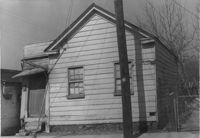
House (freedman's cottage?) on site affected by the construction of Interstate 26 (I-26). Address: 20 Addison Street. Surveyor notations on back of photo: "Dkt.: 10.503. Property owner: C.C. Scott. Tract: 94. Station: 5918+80 Lt. Date: Feb. 20, 1963. In R/W - Bought." [See collection description for explanation of surveyor notations.]
House (rear view) on site affected by the construction of Interstate 26 (I-26). 9 Wood Street. Surveyor notations on back of photo: "Dkt.: 10.503. Property owner: Janie Washington. Tract: 34. Station: 5901+00 Lt. Date: Feb. 19, 1963. In R/W - Bought." [See collection description for explanation of surveyor notations.]
House on site affected by the construction of Interstate 26 (I-26). Address: 7 Wood Street. Surveyor notations on back of photo: "Dkt.: 10.503. Property owner: Janie Washington. Tract: 34. Station: 5901+00 Lt. Date: Feb. 19, 1963. In R/W - Bought." [See collection description for explanation of surveyor notations.]
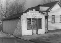
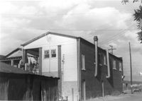
Building, possibly a store previously, on site affected by the construction of Interstate 26 (I-26). Address: 26A Addison Street [26 Addison Street]. Front facade has stepped parapet. Surveyor notations on back of photo: "Dkt.: 10.503. Property owner: Alice Campbell Johnson. Tract: 96. Station: 5919+10 Rt. Date: Feb. 20, 1963. In R/W - Bought." [See collection description for explanation of surveyor notations.]
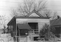
House (freedman's cottage) on site affected by the construction of Interstate 26 (I-26). Address: 26 Addison Street. Surveyor notations on back of photo: "Dkt.: 10.503. Property owner: Alice Campbell Johnson. Tract: 96. Station: 5919+00 Rt. Date: Feb. 20, 1963. In R/W - Bought." [See collection description for explanation of surveyor notations.]
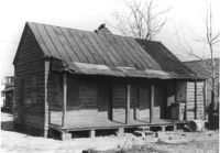
House (freedman's cottage) in dilapidated condition (side view) on site affected by the construction of Interstate 26 (I-26). Address: 107? Romney Street [107 Romney Street]. Surveyor notations on back of photo: "Dkt.: 10.503. Property owner: Louise W. Vaughan. Tract: 91. Station: 5916+35 Lt. Date: Feb. 20, 1963. In R/W - Bought." [See collection description for explanation of surveyor notations.]
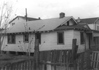
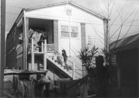
House (rear view) on site affected by the construction of Interstate 26 (I-26). Address: 15 Riker Street. Surveyor notations on back of photo: "Dkt.: 10.503. Property owner: Rosa Lee Seabrook. Tract: 70. Station: 5911+40 Lt. Date: Feb. 20, 1963. In R/W - Bought." [See collection description for explanation of surveyor notations.]
House (rear view) on site affected by the construction of Interstate 26 (I-26). Address: 5 Brigade Street. Surveyor notations on back of photo: "Dkt.: 10.503. Property owner: Maybelle Taylor. Tract: 46. Station: 5905+00 Lt. Date: Feb. 19, 1963. In R/W - Bought." [See collection description for explanation of surveyor notations.]
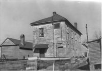
House (rear view) on site affected by the construction of Interstate 26 (I-26). Address: 1085 Meeting Street. Surveyor notations on back of photo: "Dkt.: 10.503. Property owner: Gussie Feldman. Tract: 41. Station: 5903+50 Lt. Date: Feb. 19, 1963. In R/W - Bought." [See collection description for explanation of surveyor notations.]
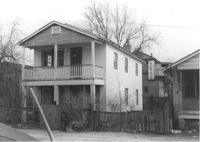
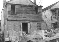
House on site affected by the construction of Interstate 26 (I-26). Address: 1085 Meeting Street. Surveyor notations on back of photo: "Dkt.: 10.503. Property owner: Gussie Feldman. Tract: 41. Station: 5903+50 Lt. (In Brigade Street R/W.) Date: Feb. 19, 1963. In R/W - Bought." [See collection description for explanation of surveyor notations.]