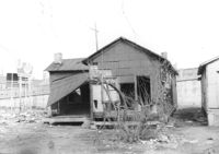
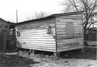
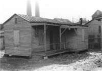
House (freedman's cottage) (rear view) on site affected by the construction of the Crosstown. Address: 115 America Street. Surveyor notations on back of photo: "Dkt.: 10.518. Property owner: Jerusalem Baptist Church. Tract: 60. Station: 49+10 Rt. N.B. lane Route 17. Date: Mar. 7, 1963." [See collection description for explanation of surveyor notations.]
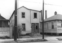
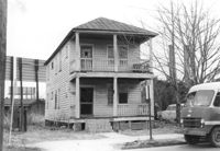
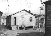
House on site affected by the construction of the Crosstown. Address: 118 America Street. Surveyor notations on back of photo: "Dkt.: 10.518. Property owner: Thelma Brown. Tract: 61. Station: 50+75 Rt. N.B. lane Route 17. Date: Mar. 7, 1963. In R/W - Bought." [See collection description for explanation of surveyor notations.]
House (rear view) on site affected by the construction of the Crosstown. Address: 118 America Street. Surveyor notations on back of photo: "Dkt.: 10.518. Property owner: Thelma Brown. Tract: 61. Station: 50+75 Rt. N.B. lane Route 17. Date: Mar. 7, 1963. In R/W - Bought." [See collection description for explanation of surveyor notations.]
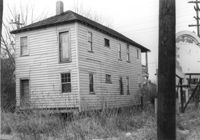
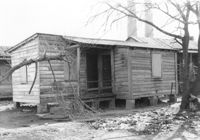
House (rear view) on site affected by the construction of the Crosstown. Address: 120 America Street. Surveyor notations on back of photo: "Dkt.: 10.518. Property owner: Geraldine M. Henry. Tract: 62. Station: 50+70 Rt. N.B. lane Route 17. Date: Mar. 7, 1963. In R/W - Bought." [See collection description for explanation of surveyor notations.]
House on site affected by the construction of the Crosstown. Address: 120 America Street. Surveyor notations on back of photo: "Dkt.: 10.518. Property owner: Geraldine M. Henry. Tract: 62. Station: 50+70 Rt. N.B. lane Route 17. Date: Mar. 7, 1963. In R/W - Bought." [See collection description for explanation of surveyor notations.]
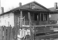
House on site affected by the construction of the Crosstown. Address: 122 America Street. Surveyor notations on back of photo: "Dkt.: 10.518. Property owner: H.B. Lasaine, et al. Tract: 63. Station: 50+70 Lt. N.B. lane Route 17. Date: Mar. 7, 1963. In R/W - Bought." [See collection description for explanation of surveyor notations.]
House (rear view) on site affected by the construction of the Crosstown. Address: 122 America Street. Surveyor notations on back of photo: "Dkt.: 10.518. Property owner: H.B. Lasaine, et al. Tract: 63. Station: 50+70 Lt. N.B. lane Route 17. Date: Mar. 7, 1963. In R/W - Bought." [See collection description for explanation of surveyor notations.]
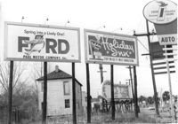
Billboards on lot, on site affected by the construction of the Crosstown. Address: 34-36 Lee Street. Surveyor notations on back of photo: "Dkt.: 10.518. Property owner: Turner Advertising. Tract: 65. Station: 51±45 Rt. & Lt. N.B. lane Route 17. Date: Mar. 7, 1963. Signs. [See collection description for explanation of surveyor notations.]
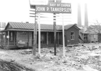
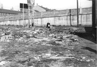
Lot on site affected by the construction of the Crosstown. Address: 32 Lee Street (south side of street). Sign for John P. Tankersley Insurance, East of Cooper. House/structure abuts lot; posted sign indicates it is closed by the Board of Health. Industrial smokestacks in background (Cigar Factory?). Surveyor notations on back of photo: "Dkt.: 10.518. Property owner: Clifton Iron. Tract: 68. Station: 52+35 Lt. N.B. lane Route 17. Date: Mar. 7, 1963. In R/W - Bought." [See collection description for explanation of surveyor notations.]
Rear of structure (see previous photo) on site affected by the construction of the Crosstown. Address: 32 Lee Street (south side of the street). Surveyor notations on back of photo: "Dkt.: 10.518. Property owner: Clifton Iron. Tract: 68. Station: 52+35 Lt. N.B. lane Route 17. Date: Mar. 7, 1963. In R/W - Bought." [See collection description for explanation of surveyor notations.]
House (rear view) on site affected by the construction of the Crosstown. Address: 39 Lee Street (south side of street). Surveyor notations on back of photo: "Dkt.: 10.518. Property owner: Yetta B. Rosen. Tract: 69. Station: 52+65 Lt. N.B. lane Route 17. Date: Mar. 7, 1963. In R/W - Bought." [See collection description for explanation of surveyor notations.]
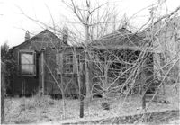
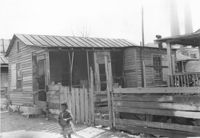
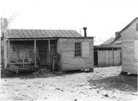
House/structure on site affected by the construction of the Crosstown. Address: 39 Lee Street (south side of street). Posted sign indicates it is closed by the Board of Health. Surveyor notations on back of photo: "Dkt.: 10.518. Property owner: Yetta B. Rosen. Tract: 69. Station: 52+65 Lt. N.B. lane Route 17. Date: Mar. 7, 1963. In R/W - Bought." [See collection description for explanation of surveyor notations.]
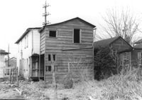
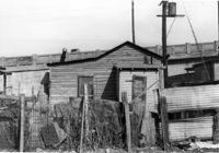
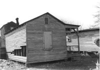
Outbuilding on site affected by the construction of the Crosstown. Address: 39 Lee Street (south side of street). Industrial smokestacks in background (Cigar Factory?). Surveyor notations on back of photo: "Dkt.: 10.518. Property owner: Yetta B. Rosen. Tract: 69. Station: 52+70 Rt. N.B. lane Route 17. Date: Mar. 7, 1963. In R/W - Bought." [See collection description for explanation of surveyor notations.]
Outbuilding on site affected by the construction of the Crosstown. Address: 39 Lee Street (south side of street). Surveyor notations on back of photo: "Dkt.: 10.518. Property owner: Yetta B. Rosen. Tract: 69. Station: 52+70 Rt. N.B. lane Route 17. Date: Mar. 7, 1963. In R/W - Bought." [See collection description for explanation of surveyor notations.]
Lot on site affected by the construction of the Crosstown. Address: 1 Lee Street. Surveyor notations on back of photo: "Dkt.: 10.518. Property owner: Ada Hamilton. Tract: 67. Station: 52+05 Lt. N.B. lane Route 17. Date: Mar. 7, 1963." [See collection description for explanation of surveyor notations.]
House (freedman's cottage) on site affected by the construction of the Crosstown. Address: 2 Lee Street. Industrial smokestacks in background (Cigar Factory?). Surveyor notations on back of photo: "Dkt.: 10.518. Property owner: Kate R. Rosen. Tract: 70. Station: 53+00 Lt. N.B. lane Route 17. Date: Mar. 7, 1963. In R/W - Bought." [See collection description for explanation of surveyor notations.]
House (freedman's cottage) (rear view) on site affected by the construction of the Crosstown. Address: 2 Lee Street. Elevated roadway (presumably the off-ramp of the Grace Memorial Bridge) in background. Surveyor notations on back of photo: "Dkt.: 10.518. Property owner: Kate R. Rosen. Tract: 70. Station: 53+00 Lt. N.B. lane Route 17. Date: Mar. 7, 1963. In R/W - Bought." [See collection description for explanation of surveyor notations.]
House (freedman's cottage) on site affected by the construction of the Crosstown. Address: 2 Lee Street. Industrial smokestacks in background (Cigar Factory?). Surveyor notations on back of photo: "Dkt.: 10.518. Property owner: Kate R. Rosen. Tract: 70. Station: 53+00 Rt. N.B. lane Route 17. Date: Mar. 7, 1963. In R/W - Bought." [See collection description for explanation of surveyor notations.]
House (freedman's cottage) (rear view) on site affected by the construction of the Crosstown. Address: 2 Lee Street. Surveyor notations on back of photo: "Dkt.: 10.518. Property owner: Kate R. Rosen. Tract: 70. Station: 53+00 Rt. N.B. lane Route 17. Date: Mar. 7, 1963. In R/W - Bought." [See collection description for explanation of surveyor notations.]
House (freedman's cottage) on site affected by the construction of the Crosstown. Address: 2 Lee Street. Surveyor notations on back of photo: "Dkt.: 10.518. Property owner: Kate R. Rosen. Tract: 71. Station: 30+00 Rt. Lee St. survey. 53+30 CL N.B. lane Rt. 17. Date: Mar. 7, 1963. In R/W - Bought." [See collection description for explanation of surveyor notations.]