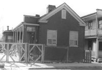
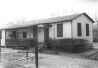
Freedman's cottage on site affected by the construction of the Crosstown. Address: 173 Nassau Street. Surveyor notations on back of photo: "Dkt.: 10.518. Property owner: Isiah Bryant, et al. Tract: 25. Station: 41+00 Lt. N.B. lane Route 17. Date: Mar. 6, 1963. In R/W - Bought. [See collection description for explanation of surveyor notations.]
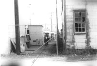
Lot between buildings, on site affected by the construction of Interstate 26 (I-26). Address: 35 Poinsett Street. Buses in background. Surveyor notations on back of photo: "Dkt.: 10.503. Property owner: S.C. Electric & Gas Co. [Tract number not indicated.] Station: 5922+50 Lt. Date: Feb. 20, 1963. Proximity." [See collection description for explanation of surveyor notations.]
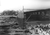
Fenced-in lot between buildings with bricks and lumber strewn about, on site affected by the construction of Interstate 26 (I-26). Located south of 35 Poinsett Street. Surveyor notations on back of photo: "Dkt.: 10.503. Property owner: Carolina Dismantling Corp. Tract: 109-A. Station: 5928± to 5929± Lt. Date: Feb. 20, 1963." [See collection description for explanation of surveyor notations.]
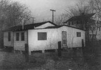
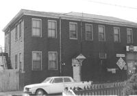
Free Kindergarten (corner view, rear) on site affected by the construction of Interstate 26 (I-26). Address: 20 Huger Street. Surveyor notations on back of photo: "Dkt.: 10.503. Property owner: Free Kindergarten Assoc. of Chas. Tract: 113. Station: 5936+50 Rt. CL. Date: Feb. 20, 1963. In R/W - Bought." [See collection description for explanation of surveyor notations.]
Free Kindergarten on site affected by the construction of Interstate 26 (I-26). Address: 20 Huger Street. Surveyor notations on back of photo: "Dkt.: 10.503. Property owner: Free Kindergarten Assoc. of Chas. Tract: 113. Station: 5936+50 Rt. & Lt. CL. Date: Feb. 20, 1963. In R/W - Bought." [See collection description for explanation of surveyor notations.]
Freedman's cottage on site affected by the construction of the Crosstown. Address: 173 Nassau Street. Surveyor notations on back of photo: "Dkt.: 10.518. Property owner: Isiah Bryant, et al. Tract: 25. Station: 41+00 Lt. N.B. lane Route 17. Date: Mar. 6, 1963. In R/W - Bought. [See collection description for explanation of surveyor notations.]
House on site affected by the construction of the Crosstown. Address: 177 Nassau Street. 179 Nassau Street partly seen to its right. Surveyor notations on back of photo: "Dkt.: 10.518. Property owner: Estelle Tompkins. Tract: 26. Station: 41+25 Lt. N.B. lane Route 17. Date: Mar. 6, 1963. Proximity. [See collection description for explanation of surveyor notations.]
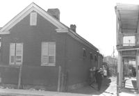
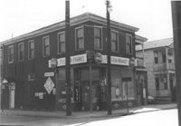
Building (residential and commercial) on site affected by the construction of the Crosstown. Address: 71 Lee Street. Sign for Ingram Fish Market on side of building. Surveyor notations on back of photo: "Dkt.: 10.518. Property owner: Virginia E.R. Ehlers. Tract: 28. Station: 41+15 CL S.B. lane Route 17. Date: Mar. 6, 1963. In R/W - Bought. [See collection description for explanation of surveyor notations.]
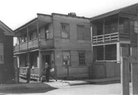
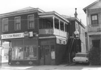
Pye's Fish Market, on site affected by the construction of the Crosstown. Address: 71 Lee Street. View of street corner. Same building as previous two photographs. `Surveyor notations on back of photo: "Dkt.: 10.518. Property owner: Virginia E.R. Ehlers. Tract: 28. Station: 41+15 CL S.B. lane Route 17. Date: Mar. 6, 1963. In R/W - Bought. [See collection description for explanation of surveyor notations.]
Pye's Fish Market, on site affected by the construction of the Crosstown. Address: 71 Lee Street. Same building as previous three photographs. `Surveyor notations on back of photo: "Dkt.: 10.518. Property owner: Virginia E.R. Ehlers. Tract: 28. Station: 41+15 CL S.B. lane Route 17. Date: Mar. 6, 1963. In R/W - Bought. [See collection description for explanation of surveyor notations.]